Category:Low Row, North Yorkshire
Jump to navigation
Jump to search
village in North Yorkshire, UK  | |||||
| Upload media | |||||
| Instance of | |||||
|---|---|---|---|---|---|
| Location | Melbecks, Richmondshire, North Yorkshire, Yorkshire and the Humber, England | ||||
 | |||||
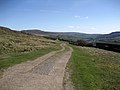
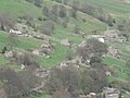
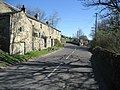
English: Low Row is a village in Swaledale, in the Yorkshire Dales, North Yorkshire, England. It lies about 3 miles west of Reeth.
Media in category "Low Row, North Yorkshire"
The following 41 files are in this category, out of 41 total.
-
 A69 above Low Row.jpg 600 × 450; 234 KB
-
 Access Lane onto Low Row Pasture - geograph.org.uk - 398017.jpg 640 × 480; 86 KB
-
 Barns at Low Row - geograph.org.uk - 590880.jpg 640 × 480; 120 KB
-

-
 Field barn, Low Row - geograph.org.uk - 2765471.jpg 640 × 425; 400 KB
-
 Gated road at Low Row - geograph.org.uk - 948972.jpg 640 × 480; 101 KB
-
 Gated track at Low Row - geograph.org.uk - 445399.jpg 640 × 479; 105 KB
-
 Hatters Roof, Low Row - geograph.org.uk - 3556733.jpg 4,000 × 3,000; 2.57 MB
-
 House, Low Row Pasture - geograph.org.uk - 2006294.jpg 640 × 480; 65 KB
-
 Low Row Farm. - geograph.org.uk - 505139.jpg 640 × 480; 108 KB
-
 Low Row Farm. - geograph.org.uk - 505144.jpg 640 × 480; 90 KB
-
 Low Row from across the dale. - geograph.org.uk - 448324.jpg 640 × 480; 138 KB
-
 Low Row, B6270 past the old chapel - geograph.org.uk - 798207.jpg 640 × 480; 72 KB
-
 Low Row, churchyard daffodils - geograph.org.uk - 798201.jpg 640 × 480; 78 KB
-
-
 Low Row, main road through village - geograph.org.uk - 798203.jpg 640 × 480; 70 KB
-
 Low Row, old school - geograph.org.uk - 796609.jpg 640 × 480; 98 KB
-
 Low Row, post office - geograph.org.uk - 796608.jpg 480 × 640; 65 KB
-
 Low Row, view from the churchyard - geograph.org.uk - 798199.jpg 640 × 480; 72 KB
-
 Low Row, view over village - geograph.org.uk - 798226.jpg 640 × 480; 74 KB
-
 Low Row.jpg 640 × 480; 118 KB
-
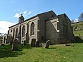
 Melbecks Parish Church, Low Row - geograph.org.uk - 2765469.jpg 640 × 425; 443 KB
-
 Out Building, Low Row - geograph.org.uk - 2927716.jpg 640 × 427; 299 KB
-
 Pastures and barns near Low Row - geograph.org.uk - 3556724.jpg 4,000 × 3,000; 2.16 MB
-

-
 Private Footpath - geograph.org.uk - 1359053.jpg 640 × 427; 177 KB
-
 Punchbowl Inn - geograph.org.uk - 2090276.jpg 640 × 426; 65 KB
-
 2013 Red Cattle in Yorkshire.jpg 4,608 × 3,456; 11.56 MB
-
 Rest a while, Low Row - geograph.org.uk - 2195872.jpg 640 × 480; 63 KB
-

-
 Rough pastures above High Closegill - geograph.org.uk - 749057.jpg 640 × 480; 85 KB
-
 Rough pastures above Low Closegill - geograph.org.uk - 749059.jpg 640 × 480; 76 KB
-

-
 Rough pastures west of Closegill - geograph.org.uk - 749043.jpg 640 × 480; 82 KB
-
 Rough pastures west of Denton Fell - geograph.org.uk - 749049.jpg 640 × 480; 72 KB
-

-
 Sign for the Punchbowl - geograph.org.uk - 2195718.jpg 480 × 640; 98 KB
-
 Swaledale hillside above Low Row - geograph.org.uk - 3480437.jpg 4,000 × 3,000; 2.04 MB
-
 Track to Low Row - geograph.org.uk - 2927711.jpg 427 × 640; 262 KB
-
 Weather vane, Low Row - geograph.org.uk - 2195864.jpg 640 × 481; 47 KB
-
 The track to Whitaside Moor - geograph.org.uk - 266318.jpg 640 × 480; 99 KB


