Category:Manoir de Saint-Christophe (Champvent)
Jump to navigation
Jump to search
| Object location | | View all coordinates using: OpenStreetMap |
|---|
buildings in Champvent in the canton of Vaud, Switzerland  | |||||
| Upload media | |||||
| Instance of | |||||
|---|---|---|---|---|---|
| Part of | |||||
| Location | |||||
| Street address |
| ||||
| Heritage designation | |||||
 | |||||
Media in category "Manoir de Saint-Christophe (Champvent)"
This category contains only the following file.
-
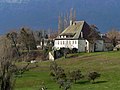 Champvent, manoir de Saint-Christophe 02.jpg 4,053 × 3,040; 1.48 MB