Category:Maps of Crawford County, Kansas
Jump to navigation
Jump to search
Counties of Kansas: Allen · Anderson · Atchison · Barber · Barton · Bourbon · Brown · Butler · Chase · Chautauqua · Cherokee · Cheyenne · Clark · Clay · Cloud · Coffey · Comanche · Cowley · Crawford · Decatur · Dickinson · Doniphan · Douglas · Edwards · Elk · Ellis · Ellsworth · Finney · Ford · Franklin · Geary · Gove · Graham · Grant · Gray · Greeley · Greenwood · Hamilton · Harper · Harvey · Haskell · Hodgeman · Jackson · Jefferson · Jewell · Johnson · Kearny · Kingman · Kiowa · Labette · Lane · Leavenworth · Lincoln · Linn · Logan · Lyon · Marion · Marshall · McPherson · Meade · Miami · Mitchell · Montgomery · Morris · Morton · Nemaha · Neosho · Ness · Norton · Osage · Osborne · Ottawa · Pawnee · Phillips · Pottawatomie · Pratt · Rawlins · Reno · Republic · Rice · Riley · Rooks · Rush · Russell · Saline · Scott · Sedgwick · Seward · Shawnee · Sheridan · Sherman · Smith · Stafford · Stanton · Stevens · Sumner · Thomas · Trego · Wabaunsee · Wallace · Washington · Wichita · Wilson · Woodson · Wyandotte
Wikimedia category | |||||
| Upload media | |||||
| Instance of | |||||
|---|---|---|---|---|---|
| Category combines topics | |||||
| Crawford County | |||||
county in Kansas, United States   | |||||
| Instance of | |||||
| Named after | |||||
| Location | Kansas | ||||
| Capital | |||||
| Inception |
| ||||
| Population |
| ||||
| Area |
| ||||
| Different from | |||||
| official website | |||||
 | |||||
Media in category "Maps of Crawford County, Kansas"
The following 32 files are in this category, out of 32 total.
-
-

-

-
-
-

-

-

-

-

-
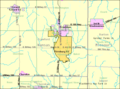 Detailed map of Pittsburg, Kansas.png 575 × 425; 33 KB
-
 Kansas Senate District 13 (2010).png 3,507 × 2,190; 313 KB
-
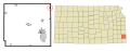
 KSMap-doton-Arcadia.png 300 × 156; 8 KB
-
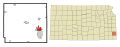
 KSMap-doton-Arma.png 300 × 156; 8 KB
-
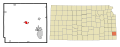
 KSMap-doton-Frontenac.png 300 × 156; 8 KB
-
 KSMap-doton-Girard.png 300 × 156; 8 KB
-
 KSMap-doton-Hepler.png 300 × 156; 8 KB
-
 KSMap-doton-McCune.png 300 × 156; 8 KB
-
 KSMap-doton-Mulberry.png 300 × 156; 8 KB
-
 KSMap-doton-Pittsburg.png 300 × 156; 8 KB
-
 KSMap-doton-Walnut.png 300 × 156; 8 KB
-
 Map highlighting Baker Township, Crawford County, Kansas.svg 512 × 512; 34 KB
-
 Map highlighting Crawford Township, Crawford County, Kansas.svg 512 × 512; 45 KB
-
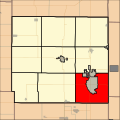
 Map highlighting Grant Township, Crawford County, Kansas.svg 512 × 512; 54 KB
-
 Map highlighting Lincoln Township, Crawford County, Kansas.svg 512 × 512; 65 KB
-
 Map highlighting Osage Township, Crawford County, Kansas.svg 512 × 512; 76 KB
-
 Map highlighting Sheridan Township, Crawford County, Kansas.svg 512 × 512; 86 KB
-
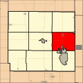
 Map highlighting Sherman Township, Crawford County, Kansas.svg 512 × 512; 97 KB
-
 Map highlighting Walnut Township, Crawford County, Kansas.svg 512 × 512; 107 KB
-
 Map highlighting Washington Township, Crawford County, Kansas.svg 512 × 512; 127 KB
-
 Map of Crawford Co, Ks, USA.png 990 × 694; 253 KB
-
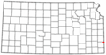
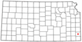
 Map of Kansas highlighting Crawford County.svg 2,202 × 1,129; 21 KB

.png)


