Category:Maps of East Godavari district
Jump to navigation
Jump to search
Wikimedia category | |||||
| Upload media | |||||
| Instance of | |||||
|---|---|---|---|---|---|
| Category combines topics | |||||
| East Godavari district | |||||
district of Andhra Pradesh, India  .svg) | |||||
| Instance of | |||||
| Location |
| ||||
| Capital |
| ||||
| Population |
| ||||
| Area |
| ||||
| official website | |||||
 | |||||
Media in category "Maps of East Godavari district"
The following 73 files are in this category, out of 73 total.
-
 Andhra Pradesh district location map East Godavari.svg 2,716 × 2,531; 369 KB
-
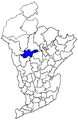
 Chinturu mandal in East Godavari district 01.png 400 × 425; 49 KB
-
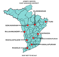 East Godavari district APSRTC Depot map.png 532 × 518; 44 KB
-
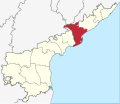
 East Godavari district in Andhra Pradesh.png 643 × 599; 91 KB
-
 East Godavari locator map.png 2,749 × 2,362; 451 KB
-
 East Godavari map.svg 2,716 × 2,348; 827 KB
-
 EastGodavariMap.png 628 × 599; 53 KB
-
 EG mandals Addateegala pre 2014.png 291 × 448; 20 KB
-
 EG mandals Ainavilli pre 2014.png 291 × 448; 20 KB
-
 EG mandals Alamuru pre 2014.png 291 × 448; 20 KB
-
 EG mandals Allavaram pre 2014.png 291 × 448; 20 KB
-
 EG mandals Amalapuram pre 2014.png 291 × 448; 20 KB
-
 EG mandals Ambajipeta pre 2014.png 291 × 448; 20 KB
-
 EG mandals Anaparthy pre 2014.png 291 × 448; 20 KB
-
 EG mandals Atreyapuram pre 2014.png 291 × 448; 20 KB
-
 EG mandals Bikkavolu pre 2014.png 291 × 448; 20 KB
-
 EG mandals Devipatnnam pre 2014.png 291 × 448; 20 KB
-
 EG mandals Gandepalli pre 2014.png 291 × 448; 20 KB
-
 EG mandals Gangavaram pre 2014.png 291 × 448; 20 KB
-
 EG mandals Gokavaram pre 2014.png 291 × 448; 20 KB
-
 EG mandals Gollaprolu pre 2014.png 291 × 448; 20 KB
-
 EG mandals I. Polavaram pre 2014.png 291 × 448; 20 KB
-
 EG mandals Jaggampeta pre 2014.png 291 × 448; 20 KB
-
 EG mandals Kadiam pre 2014.png 291 × 448; 20 KB
-
 EG mandals Kajuluru pre 2014.png 291 × 448; 20 KB
-
 EG mandals Kakinada Rural and Kakinada Urban combined pre 2014.png 291 × 448; 20 KB
-
 EG mandals Kapileswararapuram pre 2014.png 291 × 448; 20 KB
-
 EG mandals Karapa pre 2014.png 291 × 448; 20 KB
-
 EG mandals Katrenikona pre 2014.png 291 × 448; 20 KB
-
 EG mandals Kirlampudi pre 2014.png 291 × 448; 20 KB
-
 EG mandals Korukonda pre 2014.png 291 × 448; 20 KB
-
 EG mandals Kothapalli pre 2014.png 291 × 448; 20 KB
-
 EG mandals Kothapeta pre 2014.png 291 × 448; 20 KB
-
 EG mandals Malkipuram pre 2014.png 291 × 448; 20 KB
-
 EG mandals Mamidikuduru pre 2014.png 291 × 448; 20 KB
-
 EG mandals Mandapeta pre 2014.png 291 × 448; 20 KB
-
 EG mandals Maredumilli pre 2014.png 291 × 448; 20 KB
-
 EG mandals Mummidivaram pre 2014.png 291 × 448; 20 KB
-
 EG mandals Pamarru pre 2014.png 291 × 448; 20 KB
-
 EG mandals Pedapudi pre 2014.png 291 × 448; 20 KB
-
 EG mandals Peddapuram pre 2014.png 291 × 448; 20 KB
-
 EG mandals PGannavaram pre 2014.png 291 × 448; 20 KB
-
 EG mandals Pithapuram pre 2014.png 291 × 448; 20 KB
-
 EG mandals Prathipadu pre 2014.png 291 × 448; 20 KB
-

-
 EG mandals Rajanagaram pre 2014.png 291 × 448; 20 KB
-
 EG mandals Rajavommangi pre 2014.png 291 × 448; 20 KB
-
 EG mandals Rajolu pre 2014.png 291 × 448; 20 KB
-
 EG mandals Ramachandrapuram pre 2014.png 291 × 448; 20 KB
-
 EG mandals Rampachodavaram pre 2014.png 291 × 448; 20 KB
-
 EG mandals Rangampeta pre 2014.png 291 × 448; 20 KB
-
 EG mandals Ravulapalem pre 2014.png 291 × 448; 20 KB
-
 EG mandals Rayavaram pre 2014.png 291 × 448; 20 KB
-
 EG mandals Rowthulapdi and Kotananduru combined pre 2014.png 291 × 448; 20 KB
-
 EG mandals Rowthulapdi pre 2014.png 291 × 448; 21 KB
-
 EG mandals Sakhinetipalli pre 2014.png 291 × 448; 20 KB
-
 EG mandals Samarlakota pre 2014.png 291 × 448; 20 KB
-
 EG mandals Sankhavaram pre 2014.png 291 × 448; 20 KB
-
 EG mandals Seethanagaram pre 2014.png 291 × 448; 20 KB
-
 EG mandals Tallarevu pre 2014.png 291 × 448; 20 KB
-
 EG mandals Thondangi pre 2014.png 291 × 448; 20 KB
-
 EG mandals Tuni pre 2014.png 291 × 448; 20 KB
-
 EG mandals Uppalaguptam pre 2014.png 291 × 448; 20 KB
-
 EG mandals Yeleswaram pre 2014.png 291 × 448; 20 KB
-
 EG mandals YRamavaram pre 2014.png 291 × 448; 20 KB
-
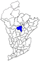
 Kunavaram mandal in East Godavari district.png 399 × 435; 48 KB
-
 Location map of Buddhist sites in East Godavari District.png 400 × 517; 54 KB
-
 Rajahmundry revenue division in East Godavari district.png 456 × 505; 74 KB
-
 Rampachodavaram revenue division in East Godavari district.png 456 × 505; 74 KB
-
 Revenue divisions map of East Godavari district.png 492 × 530; 94 KB
-
 VR Puram mandal in East Godavari district.png 399 × 435; 36 KB
-
 Yetapaka mandal in East Godavari district.png 350 × 375; 36 KB
-
 Yetapaka revenue division in East Godavari district.png 456 × 505; 74 KB


