Category:Maps of Zealand
Jump to navigation
Jump to search
Wikimedia category | |||||
| Upload media | |||||
| Instance of | |||||
|---|---|---|---|---|---|
| Category combines topics | |||||
| Zealand | |||||
island in Denmark  Satelitní snímek  | |||||
| Instance of | |||||
| Part of | |||||
| Location |
| ||||
| Located in or next to body of water | |||||
| Width |
| ||||
| Length |
| ||||
| Population |
| ||||
| Area |
| ||||
| Different from | |||||
 | |||||
Media in category "Maps of Zealand"
The following 36 files are in this category, out of 36 total.
-
-
 "Zeelandia insula danicarum maxima." (22266873331).jpg 3,796 × 3,105; 1.93 MB
-
 20180824 Greater Copenhagen and Halland Dk (43516348364).jpg 7,016 × 4,961; 1.2 MB
-

-

-

-

-
 Amager i Sund ubt 1 DA.png 237 × 345; 59 KB
-
 Denmark location sjalland.svg 1,836 × 1,479; 362 KB
-
 DenmarkZealand.png 200 × 240; 27 KB
-
 DK - Zealand.PNG 449 × 557; 16 KB
-
 DK Sjælland kommuner.png 1,170 × 1,458; 86 KB
-
 Dk-wyspy.png 413 × 341; 100 KB
-
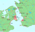
 Greater Copenhagen kort.jpg 641 × 481; 61 KB
-
 La2-demis-sjaelland.png 392 × 580; 193 KB
-
 Locaation map Denmark Zealand.png 909 × 854; 699 KB
-
 Map - Spanish - Oresund.png 666 × 587; 898 KB
-
 Map - Special Collections University of Amsterdam - OTM- HB-KZL 31-11-16.tif 6,688 × 5,487; 104.99 MB
-
 Map of Öresund between Denmark and Sweden - no text.png 924 × 832; 203 KB
-
 Map of Öresund between Denmark and Sweden.png 924 × 832; 205 KB
-
 Map of Øresund new version.JPG 465 × 614; 71 KB
-
 Matrikelkort Dåstrup 1808-1859 oe 0050253 (cropped).jpg 1,018 × 1,072; 243 KB
-
 Matrikelkort Dåstrup 1808-1859 oe 0050253.jpg 4,600 × 7,088; 4.87 MB
-
 Matrikelkort Dåstrup 1859-1878 OT 0050253 1878 (cropped).jpg 800 × 827; 170 KB
-
 Matrikelkort Dåstrup 1859-1878 OT 0050253 1878.jpg 3,700 × 6,682; 4.71 MB
-
 Matrikelkort Dåstrup 1878-1961 OT 0050253 1961 (cropped).jpg 781 × 704; 141 KB
-
 Matrikelkort Dåstrup 1878-1961 OT 0050253 1961.jpg 5,000 × 6,254; 4.84 MB
-
 Ods Herred Old Map 1768.jpg 745 × 847; 101 KB
-
 Odsherredbuerne Figur1.tif 505 × 559, 2 pages; 891 KB
-
 Odsherredbuerne Figur4.jpg 1,319 × 2,002; 477 KB
-
 Oversigtskort til Krigsbegivenhederne i Sjælland Aaret 1807.jpg 2,590 × 3,234; 953 KB
-
 Region Hovedstaden (only the Zealand part without Bornholm).jpg 465 × 550; 62 KB
-
 Region Sjælland (only the Zealand part).jpg 200 × 240; 21 KB
-
 Store Merløse.png 611 × 417; 515 KB
-
 Trigonometrisk Carte over Siæland.jpg 6,900 × 5,113; 7.12 MB
-
 Zeelandia Insula with subdivision by Blaeu 1665.jpg 6,574 × 5,366; 6.83 MB

.jpg)
.jpg)
%27_(11096291206).jpg)
.jpg)
.jpg)
.jpg)


.jpg)

.jpg)

.jpg)


.jpg)
.jpg)


