Category:March 2018 in the East Riding of Yorkshire
Jump to navigation
Jump to search
Ceremonial counties of England: Bedfordshire · Berkshire · Cheshire · Cornwall · Cumbria · Derbyshire · Devon · Dorset · Durham · East Riding of Yorkshire · Essex · Gloucestershire · Greater London · Greater Manchester · Hampshire · Herefordshire · Kent · Lancashire · Leicestershire · Lincolnshire · Merseyside · Norfolk · North Yorkshire · Northamptonshire · Northumberland · Nottinghamshire · Oxfordshire · Shropshire · Somerset · South Yorkshire · Staffordshire · Suffolk · Surrey · Warwickshire · West Sussex · West Yorkshire · Wiltshire · Worcestershire
City-counties: Bristol ·
Former historic counties:
Other former counties:
City-counties: Bristol ·
Former historic counties:
Other former counties:
Deutsch: Bilder, die im März 2018 in the East Riding of Yorkshire aufgenommen worden sind. Bitte beachten Sie, dass dies weder das Datum des Uploads noch das Datum des Scannens eines Fotos ist.
English: Images/pictures taken in the East Riding of Yorkshire during March 2018. Note this is not the date of the upload, nor the date a photo was scanned.
Español: Fotografías o imágenes tomadas en the East Riding of Yorkshire durante marzo 2018. No es la fecha de subida ni escaneo, sino la fecha en que las fotografías o imágenes se crearon.
Esperanto: Bildoj faritaj en the East Riding of Yorkshire en marto 2018. Tio ne estas la dato, kiam la bildoj estis alŝutitaj aŭ skanitaj.
Français : Photographies ou images prises en the East Riding of Yorkshire durant mars 2018. Ce n'est pas la date du téléchargement ou du scan.
Galego: Fotografías ou imaxes tomadas en the East Riding of Yorkshire durante marzo 2018. Non é a data de subida nin escaneamento, senón a data na que se crearon as fotografías ou imaxes.
Italiano: Fotografie o immagini scattate a the East Riding of Yorkshire nel marzo 2018. Nota bene: la data non si riferisce né a quella di upload né a quella in cui la foto è stata digitalizzata.
Norsk bokmål: Bilder tatt i the East Riding of Yorkshire i løpet av mars 2018. Merk at dette ikke er datoen for opplasting, eller når et bilde har blitt skannet.
Norsk nynorsk: Bilete teke i the East Riding of Yorkshire i løpet av mars 2018. Merk at dette ikkje er datoen for opplasting, eller når eit bilete har vorte skanna.
Русский: Изображения, сделанные в the East Riding of Yorkshire в течение март 2018 (не дата загрузки изображения).
Українська: Зображення, зроблені в the East Riding of Yorkshire протягом березень 2018. Зауважте, що це не дата завантаження чи дата сканування фотографії.
| March 2017 | ← | March 2018 | → | March 2019 | |||||||
| Jan | Feb | Mar | Apr | May | Jun | Jul | Aug | Sep | Oct | Nov | Dec |
| 95 | 47 | 36 | 62 | 47 | 47 | 38 | 24 | 45 | 100 | 23 | 51 |
|---|---|---|---|---|---|---|---|---|---|---|---|
Media in category "March 2018 in the East Riding of Yorkshire"
The following 36 files are in this category, out of 36 total.
-

-
 Alongside a plantation near Warter (geograph 5715570).jpg 1,024 × 768; 284 KB
-
 Beck at Yapham Green (geograph 5717929).jpg 1,600 × 1,200; 958 KB
-
 Bricknall Avenue toward junction with B1233 Hull Road (geograph 5699511).jpg 4,608 × 3,456; 5.23 MB
-
 Camping (and glamping) at Yapham Holds Farm (geograph 5717935).jpg 1,600 × 1,200; 641 KB
-

-
 Coast SW of Skeffling - aerial 2018 (geograph 5719041).jpg 640 × 427; 43 KB
-
 Earthwork at Deepdale Plantation (geograph 5715591).jpg 1,024 × 768; 358 KB
-
 Entrance to Belsom Farm (geograph 5717937).jpg 1,600 × 1,200; 570 KB
-
 Entrance to Warter Wold Farm (geograph 5717799).jpg 1,024 × 768; 313 KB
-
 Entrance to Willow Farm (geograph 5717626).jpg 1,600 × 1,200; 711 KB
-
 Footbridge near Bolton House (geograph 5717904).jpg 1,600 × 1,200; 949 KB
-
 Footpath from Meltonby Lane towards Yapham (geograph 5717934).jpg 1,600 × 1,200; 674 KB
-
 Green Lane Farm (geograph 5708615).jpg 640 × 480; 63 KB
-
 Haltemprice Crematorium (geograph 5708612).jpg 640 × 480; 59 KB
-
 Holly and the Humber (geograph 5699361).jpg 1,024 × 768; 170 KB
-
 Kirk Ella Church (geograph 5708594).jpg 640 × 480; 94 KB
-
 New Lidl, Hull (geograph 5713205).jpg 640 × 442; 137 KB
-
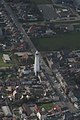
 North Pier, Bridlington (geograph 5712856).jpg 640 × 361; 49 KB
-

-

-
 Old line of road east of Wilberfoss (geograph 5717624).jpg 1,600 × 1,200; 1,008 KB
-
 Paraglider near Withernwick- aerial 2018 (geograph 5720134).jpg 800 × 533; 70 KB
-
 Roadside pit near Warter (geograph 5717802).jpg 1,024 × 768; 340 KB
-
 Rowland Hill Farm (geograph 5717927).jpg 1,600 × 1,200; 575 KB
-
 Sharp bend on Meltonby Lane (geograph 5717933).jpg 1,600 × 1,200; 868 KB
-
 Skeffling Clough - aerial 2018 (geograph 5719062).jpg 640 × 427; 49 KB
-
 South Lodge (geograph 5717630).jpg 1,600 × 1,200; 690 KB
-
 View into Well Dale from near Cobdale Cottage (geograph 5715614).jpg 1,024 × 768; 142 KB
-
 Well Lane, Willerby (geograph 5708609).jpg 640 × 482; 42 KB
-
 Wet weather Willerby Waitrose (geograph 5708618).jpg 640 × 480; 59 KB
-
 Willy Howe and Burton Fleming- aerial 2018 (geograph 5720676).jpg 640 × 411; 46 KB
-
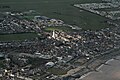 Withernsea- aerial 2018 (1) (geograph 5719094).jpg 800 × 533; 113 KB
-
 Withernsea- aerial 2018 (2) (geograph 5719097).jpg 427 × 640; 66 KB
-
 Wold Newton to the sea- aerial 2018 (geograph 5720700).jpg 640 × 427; 55 KB
-
 Yapham (geograph 5717931).jpg 1,600 × 1,200; 579 KB
.jpg)
.jpg)
.jpg)
.jpg)
_at_Yapham_Holds_Farm_(geograph_5717935).jpg)
.jpg)
.jpg)
.jpg)
.jpg)
.jpg)
.jpg)
.jpg)
.jpg)
.jpg)
.jpg)
.jpg)
.jpg)
.jpg)
.jpg)
.jpg)
.jpg)
.jpg)
.jpg)
.jpg)
.jpg)
.jpg)
.jpg)
.jpg)
.jpg)
.jpg)
.jpg)
.jpg)
_(geograph_5719094).jpg)
_(geograph_5719097).jpg)
.jpg)
.jpg)