Category:Mud Springs station site (Morrill County, Nebraska)
Jump to navigation
Jump to search
| Object location | | View all coordinates using: OpenStreetMap |
|---|
place in Nebraska listed on National Register of Historic Places  | |||||
| Upload media | |||||
| Instance of | |||||
|---|---|---|---|---|---|
| Location | Morrill County, Nebraska | ||||
| Heritage designation | |||||
 | |||||
Media in category "Mud Springs station site (Morrill County, Nebraska)"
The following 3 files are in this category, out of 3 total.
-

-
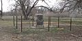 Mud Springs Station monument 1.JPG 2,560 × 1,285; 1.29 MB
-
 Mud Springs Station monument 2.JPG 1,795 × 1,869; 1.36 MB
_on_the_California_and_Pony_Express_National_Historic_Trails_(2005)_(db3f708a-02aa-405b-b5f5-6ddb3c6d31a3).jpg)
