Category:När fyr
Jump to navigation
Jump to search
| Object location | | View all coordinates using: OpenStreetMap |
|---|
|
This is a category about a protected building in Sweden, number 21000001632502 in the RAÄ buildings database.
|
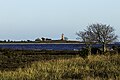
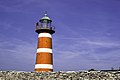
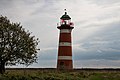
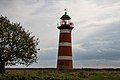
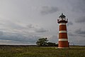
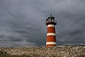
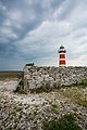
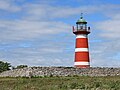
English: När Lighthouse
lighthouse in Gotland Municipality, Sweden  | |||||
| Upload media | |||||
| Instance of | |||||
|---|---|---|---|---|---|
| Made from material |
| ||||
| Location | När, När District, Gotland Municipality, Gotland County, Sweden | ||||
| Located in or next to body of water | |||||
| Architect |
| ||||
| Owned by | |||||
| Heritage designation |
| ||||
| Inception |
| ||||
| Significant event |
| ||||
| Source of energy |
| ||||
| Height |
| ||||
 | |||||
Media in category "När fyr"
The following 26 files are in this category, out of 26 total.
-
 Faro de När 02.jpg 6,000 × 4,000; 15.31 MB
-
 Faro de När.jpg 5,100 × 3,400; 10.12 MB
-
 Gotland Lighthouse with Echium vulgare.JPG 4,912 × 3,264; 7.01 MB
-
 L1021915 (30009777965).jpg 5,216 × 3,472; 4.78 MB
-
 Lighthouse (29768144723).jpg 6,000 × 4,000; 9.49 MB
-
 Lighthouse (29794330430).jpg 5,809 × 3,873; 9.09 MB
-
 Lighthouse (30086467370).jpg 5,732 × 3,821; 7.39 MB
-
 Lighthouse (30123857805).jpg 5,718 × 3,812; 2.33 MB
-
 Lighthouse (30340898501).jpg 6,000 × 4,000; 8.65 MB
-
 Lighthouse (30555263235).jpg 6,000 × 4,000; 11.97 MB
-
 Narsfyr-10.jpg 6,000 × 4,000; 11.97 MB
-
 Narsfyr-5.jpg 5,809 × 3,873; 9.09 MB
-
 Narsfyr-6.jpg 5,732 × 3,821; 7.39 MB
-
 Narsfyr-7.jpg 6,000 × 4,000; 8.65 MB
-
 Narsfyr-8.jpg 6,000 × 4,000; 9.49 MB
-
 Narsfyr-9.jpg 5,718 × 3,812; 6.91 MB
-
 Narshamns fyr DSC 2375.jpg 3,673 × 2,660; 4.39 MB
-
 Narsholmen fyr, När, Gotland.jpg 1,200 × 1,807; 936 KB
-
 När lighthouse (7881618336).jpg 1,686 × 2,560; 1.34 MB
-
 Närholmens fyr Gotland 1.jpg 2,333 × 3,500; 6.57 MB
-
 Närholmens fyr Gotland 2.jpg 3,500 × 2,333; 6.26 MB
-
 Närholmens fyr Gotland 3.jpg 3,500 × 2,333; 6.43 MB
-
 Närsholmen Leuchtturm.JPG 3,059 × 2,294; 605 KB
-
 Närsholmens fyrplats - KMB - 16001000200384.jpg 522 × 787; 52 KB
-
 Närsholmens fyrplats - KMB - 16001000200404.jpg 787 × 522; 55 KB
-
 Närsholmens fyrplats - KMB - 16001000200424.jpg 522 × 787; 63 KB


.jpg)
.jpg)
.jpg)
.jpg)
.jpg)
.jpg)
.jpg)


.jpg)


