Category:Nainital
Zur Navigation springen
Zur Suche springen
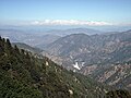
Nainital (Hindi: नैनीताल) is a town and hill station in the Indian state of Uttarakhand and headquarters of Nainital district in the Kumaon foothills of the outer Himalayas. Situated at an altitude of 1,938 metres (6,358 feet) above sea level, Nainital is set in a valley containing the pear-shaped Nainital lake, and surrounded by mountains. 29°22′48″N 79°27′0″E / 29.38°N 79.45°E
Stadt in Uttarakhand, Indien  | |||||
| Medium hochladen | |||||
| Aussprache (Audiodatei) | |||||
|---|---|---|---|---|---|
| Ist ein(e) | |||||
| Ort | Nainital, Division Kumaon, Uttarakhand, Indien | ||||
| Einwohnerzahl |
| ||||
| Fläche |
| ||||
| Höhe über dem Meeresspiegel |
| ||||
| offizielle Website | |||||
 | |||||
Unterkategorien
Es werden 8 von insgesamt 8 Unterkategorien in dieser Kategorie angezeigt:
In Klammern die Anzahl der enthaltenen Kategorien (K), Seiten (S), Dateien (D)
Medien in der Kategorie „Nainital“
Folgende 3 Dateien sind in dieser Kategorie, von 3 insgesamt.
-
 Himalayan range as visible from Nainital, India.jpg 6.016 × 3.607; 14,14 MB
-
 Nainital View Point.jpg 4.000 × 3.000; 9,24 MB
-
 Uttarakhand kkmishra.jpg 4.000 × 3.000; 8,4 MB


