Category:Nainital
Vai alla navigazione
Vai alla ricerca
Nainital (Hindi: नैनीताल) is a town and hill station in the Indian state of Uttarakhand and headquarters of Nainital district in the Kumaon foothills of the outer Himalayas. Situated at an altitude of 1,938 metres (6,358 feet) above sea level, Nainital is set in a valley containing the pear-shaped Nainital lake, and surrounded by mountains. 29°22′48″N 79°27′0″E / 29.38°N 79.45°E
villaggio dell'India  | |||||
| Carica un file multimediale | |||||
| Audio della pronuncia | |||||
|---|---|---|---|---|---|
| Istanza di | |||||
| Luogo | distretto di Nainital, divisione del Kumaon, Uttarakhand, India | ||||
| Popolazione |
| ||||
| Superficie |
| ||||
| Altezza sul mare |
| ||||
| sito web ufficiale | |||||
 | |||||
Sottocategorie
Questa categoria contiene le 8 sottocategorie indicate di seguito, su un totale di 8.
Pagine nella categoria "Nainital"
Questa categoria contiene un'unica pagina, indicata di seguito.
File nella categoria "Nainital"
Questa categoria contiene 3 file, indicati di seguito, su un totale di 3.
-
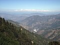
 Himalayan range as visible from Nainital, India.jpg 6 016 × 3 607; 14,14 MB
-
 Nainital View Point.jpg 4 000 × 3 000; 9,24 MB
-
 Uttarakhand kkmishra.jpg 4 000 × 3 000; 8,4 MB


