Category:Nesweg 10, Texel
Jump to navigation
Jump to search
| NO WIKIDATA ID FOUND! Search for Nesweg 10, Texel on Wikidata | |
| Upload media |
| Object location | | View all coordinates using: OpenStreetMap |
|---|
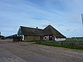
Nederlands: Boerderij De Nes - Nesweg 10 - Oosterend - anno 1691
|
This is a category about rijksmonument number 35192
|
Media in category "Nesweg 10, Texel"
The following 9 files are in this category, out of 9 total.
-
 Boerderij Nesweg 10 - Oosterend.jpg 3,648 × 2,736; 4.71 MB
-
 O.33, aanzicht - Oosterend - 20174513 - RCE.jpg 1,200 × 943; 262 KB
-
 O.33, achterzijde boerderij schuur - Oosterend - 20174519 - RCE.jpg 1,200 × 962; 296 KB
-
 O.33, overzicht - Oosterend - 20174512 - RCE.jpg 1,200 × 963; 285 KB
-
 O.33, overzicht - Oosterend - 20174516 - RCE.jpg 1,200 × 959; 259 KB
-
 O.33, overzicht - Oosterend - 20174517 - RCE.jpg 1,200 × 959; 278 KB
-
 O.33, overzicht - Oosterend - 20174518 - RCE.jpg 1,200 × 964; 261 KB
-
 O.33, schuur - Oosterend - 20174514 - RCE.jpg 1,200 × 957; 281 KB
-
 Voorgevel nr. Texel 21 - Oosterend - 20469514 - RCE.jpg 1,200 × 900; 237 KB


