Category:New Century Atlas of Greater Buffalo, Vol. 2
Jump to navigation
Jump to search
Media in category "New Century Atlas of Greater Buffalo, Vol. 2"
The following 30 files are in this category, out of 30 total.
-

-

-

-

-

-

-
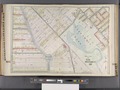
 Buffalo, V. 2, Double Page Plate No. 35 (Map bounded by Buffalo River, Ohio St., Lake Erie) NYPL2056922.tiff 7,216 × 5,412, 2 pages; 112 MB
-
 Buffalo, V. 2, Double Page Plate No. 36 (Map bounded by Elk St., Buffalo River, Michigan Ave.) NYPL2056923.tiff 7,216 × 5,412, 2 pages; 112 MB
-

-
 Buffalo, V. 2, Double Page Plate No. 38 (Map bounded by Broadway, Fillmore Ave., Eagle St., Pratt St.) NYPL2056925.tiff 7,216 × 5,412, 2 pages; 112 MB
-

-

-
 Buffalo, V. 2, Double Page Plate No. 41 (Map bounded by Walden Ave., Reimann St., Deshler St.) NYPL2056928.tiff 7,216 × 5,412, 2 pages; 112 MB
-

-
 Buffalo, V. 2, Double Page Plate No. 43 (Map bounded by Broadway, Peck St., William St., Fillmore Ave.) NYPL2056930.tiff 7,216 × 5,412, 2 pages; 112 MB
-

-
 Buffalo, V. 2, Double Page Plate No. 45 (Map bounded by William St., Cambria St., Griswold St.) NYPL2056932.tiff 7,216 × 5,412, 2 pages; 112 MB
-

-

-

-

-

-
 Buffalo, V. 2, Double Page Plate No. 51 (Map bounded by Woodside Ave., S. Park Ave.) NYPL2056938.tiff 7,216 × 5,412, 2 pages; 112 MB
-
 Buffalo, V. 2, Double Page Plate No. 52 (Map bounded by Beacon St., S. Park Ave., S. Buffalo Rail Rd.) NYPL2056939.tiff 7,216 × 5,412, 2 pages; 112 MB
-
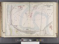 Buffalo, V. 2, Double Page Plate No. 53 (Map bounded by Sandusky St., Lake Erie) NYPL2056940.tiff 7,216 × 5,412, 2 pages; 112 MB
-
 Buffalo, V. 2, Double Page Plate No. 54 (Map bounded by S. Buffalo Rail Rd., Tifft St., Lake Erie) NYPL2056941.tiff 7,216 × 5,412, 2 pages; 112 MB
-
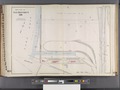 Buffalo, V. 2, Double Page Plate No. 55 (Map bounded by Tifft St., S. Buffalo Rail Rd., Lake Erie) NYPL2056942.tiff 7,216 × 5,412, 2 pages; 112 MB
-

-

-
 The new century atlas of Greater Buffalo. Vol. 2. Century Atlas co., Philadelphia, 1915. NYPL2056913.tiff 7,216 × 5,412, 2 pages; 112 MB