Category:Old First Presbyterian Church (Newark, Delaware)
Jump to navigation
Jump to search
| Object location | | View all coordinates using: OpenStreetMap |
|---|
|
This is a category about a place or building that is listed on the National Register of Historic Places in the United States of America. Its reference number is 82002347. |
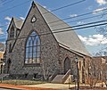
church building in Delaware, United States of America  | |||||
| Upload media | |||||
| Instance of | |||||
|---|---|---|---|---|---|
| Location | Delaware | ||||
| Heritage designation |
| ||||
 | |||||
Media in category "Old First Presbyterian Church (Newark, Delaware)"
The following 4 files are in this category, out of 4 total.
-
 Old 1st Presby Newark DE.JPG 3,772 × 3,772; 5.62 MB
-
 Old First Presbyterian Church Newark DE Apr 10.JPG 2,592 × 1,944; 780 KB
-
 Old First Presbyterian Church Newark Delaware.jpg 4,511 × 3,007; 6.18 MB
-
 OLD FIRST PRESBYTERIAN CHURCH, NEWARK, NORTHERN NEW CASTLE COUNTY, DE.jpg 2,100 × 1,776; 527 KB


Categories:
- National Register of Historic Places in Newark, Delaware
- Buildings of religious function on the National Register of Historic Places in Delaware
- Presbyterian Church (USA) churches in Delaware
- Stone churches in Delaware
- University of Delaware
- Former churches in Delaware
- Buildings in Newark, Delaware
- Churches of the New Castle Presbytery