Category:Oudebrugsteeg 7, Amsterdam
Jump to navigation
Jump to search
| Object location | | View all coordinates using: OpenStreetMap |
|---|
| NO WIKIDATA ID FOUND! Search for Oudebrugsteeg 7, Amsterdam on Wikidata | |
| Upload media |
|
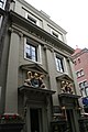
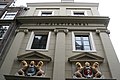
This is a category about rijksmonument number 3971
|
| Address |
|
Media in category "Oudebrugsteeg 7, Amsterdam"
The following 11 files are in this category, out of 11 total.
-
 3971 Amsterdam, Oudebrugsteeg 7 (1).JPG 2,304 × 3,456; 3.46 MB
-
 3971 Amsterdam, Oudebrugsteeg 7 (2).JPG 2,304 × 3,456; 2.87 MB
-
 3971 Amsterdam, Oudebrugsteeg 7 (3).JPG 3,456 × 2,304; 3.11 MB
-
 3971 Amsterdam, Oudebrugsteeg 7 (4).JPG 2,304 × 3,456; 3.32 MB
-
 3971 Amsterdam, Oudebrugsteeg 7 detail1.JPG 3,456 × 2,304; 3.99 MB
-
 3971 Amsterdam, Oudebrugsteeg 7 detail2.JPG 3,456 × 2,304; 3.8 MB
-
 3971 Amsterdam, Oudebrugsteeg 7 detail3.JPG 3,456 × 2,304; 3.84 MB
-
 3971 Amsterdam, Oudebrugsteeg 7 gevel.JPG 3,456 × 2,304; 3.69 MB
-
 3971 Amsterdam, Oudebrugsteeg 7 info.JPG 3,456 × 2,304; 4.29 MB
-
 Stadsarchief Amsterdam, Afb 012000005324.jpg 1,999 × 1,454; 427 KB
-
 Stadsarchief Amsterdam, Afb 012000005327.jpg 1,980 × 1,446; 415 KB
.JPG)
.JPG)
.JPG)
.JPG)


