Category:Ouray County, Colorado
Jump to navigation
Jump to search
Counties of Colorado: Adams · Alamosa · Arapahoe · Archuleta · Baca · Bent · Boulder · Chaffee · Cheyenne · Clear Creek · Conejos · Costilla · Crowley · Custer · Delta · Dolores · Douglas · Eagle · El Paso · Elbert · Fremont · Garfield · Gilpin · Grand · Gunnison · Hinsdale · Huerfano · Jackson · Jefferson · Kiowa · Kit Carson · Lake · La Plata · Larimer · Las Animas · Lincoln · Logan · Mesa · Mineral · Moffat · Montezuma · Montrose · Morgan · Otero · Ouray · Park · Phillips · Pitkin · Prowers · Pueblo · Rio Blanco · Rio Grande · Routt · Saguache · San Juan · San Miguel · Sedgwick · Summit · Teller · Washington · Weld · Yuma
City-counties: Broomfield · Denver
City-counties: Broomfield · Denver
county in Colorado, United States    | |||||
| Upload media | |||||
| Instance of | |||||
|---|---|---|---|---|---|
| Named after | |||||
| Location | Colorado | ||||
| Capital | |||||
| Inception |
| ||||
| Highest point | |||||
| Population |
| ||||
| Area |
| ||||
| official website | |||||
 | |||||
Ouray County is a county in Colorado, United States.
Subcategories
This category has the following 11 subcategories, out of 11 total.
B
G
M
P
T
Media in category "Ouray County, Colorado"
The following 64 files are in this category, out of 64 total.
-
 A burro train bringing gold from the mines near Ouray, Colorado (94505266).jpg 2,484 × 2,484; 1.63 MB
-
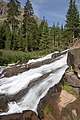 Above Twin Falls (198537672).jpg 2,336 × 3,504; 2.04 MB
-
 Above Twin Falls (198539249).jpg 2,336 × 3,504; 2.85 MB
-

-
 Bulletin of the Geological Society of America (1905) (20262010800).jpg 3,168 × 2,260; 1.01 MB
-
 Crystal lake (5996675616).jpg 427 × 640; 63 KB
-
 Crystal lake HDR (5996672708).jpg 4,768 × 3,176; 2.03 MB
-
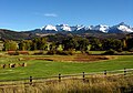
 Farmland in Pleasant Valley near Ridgway, Ouray County, Colorado LCCN2017877621.jpg 5,432 × 3,856; 1.83 MB
-
 Farmland in Pleasant Valley near Ridgway1a34175v.jpg 949 × 651; 365 KB
-
 Farmland in the vicinity of Mt. Sneffels 1a34177v.jpg 942 × 639; 346 KB
-
 Farmland in the vicinity of Mt. Sneffels 1a34182v.jpg 939 × 646; 303 KB
-
 Farmland in the vicinity of Mt. Sneffels, Ouray County, Colorado LCCN2017877617.jpg 5,495 × 3,884; 1.64 MB
-
 Farmland in the vicinity of Mt. Sneffels, Ouray County, Colorado LCCN2017877623.jpg 5,495 × 3,856; 1.79 MB
-
 Farmland in the vicinity of Mt. Sneffels, Ouray County, Colorado LCCN2017877628.jpg 4,808 × 3,423; 1.43 MB
-
 Farmland in the vicinity of Mt. Sneffels1a34171v.jpg 937 × 643; 330 KB
-
 Gold on Bear Creek, CO.jpg 2,146 × 2,704; 6.12 MB
-

-
-
 Idaradoslag.JPG 2,560 × 1,920; 809 KB
-
 Idaradotrestle.JPG 2,560 × 1,920; 758 KB
-

-
 LogHillCO.jpg 2,304 × 1,728; 611 KB
-
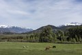
 Longhaired Highland cattle graze near Ridgway in Ouray County, Colorado LCCN2015632455.tif 7,360 × 4,912; 206.9 MB
-
 Longhaired Highland cattle graze near Ridgway in Ouray County, Colorado LCCN2015632456.tif 7,360 × 4,912; 206.9 MB
-
 Longhaired highland cattle graze near Ridgway in Ouray County, Colorado LCCN2015632458.tif 7,360 × 4,912; 206.9 MB
-
 Longhaired Highland cattle graze near Ridgway in Ouray County, Colorado LCCN2015632461.tif 7,360 × 4,912; 206.9 MB
-

-

-

-

-

-
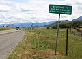 Ouray County line sign.JPG 4,761 × 3,418; 10.83 MB
-
 Ouray County, CO, USA - panoramio.jpg 1,439 × 966; 1.65 MB
-
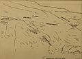
 Ouray mines geologic map.jpg 798 × 825; 153 KB
-
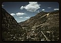 Ouray, Colorado LCCN2017877618.jpg 5,502 × 3,863; 1.94 MB
-
 Ouray, Colorado1a34172v.jpg 938 × 640; 412 KB
-
 OurayCountyColoradoMtSneffels.jpg 616 × 431; 213 KB
-
 Red Mounatin Mines in the snow - panoramio (1).jpg 3,264 × 2,448; 2.81 MB
-
 Red Mounatin Mines in the snow - panoramio (2).jpg 3,264 × 2,448; 2.75 MB
-
 Red Mounatin Mines in the snow - panoramio.jpg 3,264 × 2,448; 3.23 MB
-
 Red Mountain pass cliff (5996120851).jpg 640 × 427; 101 KB
-
 RedMountainPassSign.jpg 1,200 × 864; 205 KB
-
 Ridgway State Park.jpg 3,264 × 2,448; 3.19 MB
-
 Rocky slope with a deer - panoramio.jpg 3,264 × 2,176; 2.76 MB
-

-

-
-
 Twin Falls (198532604).jpg 3,504 × 2,336; 2.59 MB
-
 Twin Falls (198533524).jpg 2,336 × 3,504; 2.03 MB
-
-
 Uncompahgre outcrop.jpg 665 × 705; 132 KB
-
 Upperportionofyankeeboybasin2005.jpg 2,272 × 1,704; 1.81 MB
-
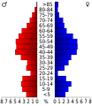 USA Ouray County, Colorado age pyramid.svg 520 × 600; 8 KB
-
 Waterfall (4006655647).jpg 2,611 × 3,868; 6.66 MB
-
 Waterfall (4007425352).jpg 2,611 × 3,872; 4.85 MB
-
 Wildflowers in California Gulch (200731386).jpg 3,504 × 2,336; 2.87 MB
-
 Wildflowers in California Gulch (200732398).jpg 3,504 × 2,336; 3.86 MB
-
 Wildflowers on the way to Cinnamon Pass (200735667).jpg 2,336 × 3,504; 3.26 MB
-

-

-

-

-

-
 Wright's lake - panoramio.jpg 3,264 × 1,832; 2.13 MB
.jpg)
.jpg)
.jpg)
_(20262010800).jpg)
.jpg)
.jpg)


.jpg)
.jpg)

.jpg)


.jpg)
.jpg)
.jpg)
.jpg)


.jpg)
.jpg)
.jpg)
.jpg)
.jpg)
