Category:Pauperhaugh
Jump to navigation
Jump to search
hamlet and former civil parish in Northumberland, England | |||||
| Upload media | |||||
| Instance of |
| ||||
|---|---|---|---|---|---|
| Location | Brinkburn, Northumberland, North East England, England | ||||
 | |||||
Media in category "Pauperhaugh"
The following 34 files are in this category, out of 34 total.
-
 Abandoned cottage near West Raw Farm - geograph.org.uk - 1427205.jpg 640 × 480; 115 KB
-
 Access land below Healey - geograph.org.uk - 306394.jpg 640 × 480; 139 KB
-
 Black Burn - geograph.org.uk - 306590.jpg 640 × 480; 122 KB
-
 Black Burn - geograph.org.uk - 306646.jpg 640 × 480; 152 KB
-
 Black Burn from footbridge near Cragend - geograph.org.uk - 306675.jpg 480 × 640; 130 KB
-
 Bridge over the Black Burn - geograph.org.uk - 306416.jpg 640 × 480; 124 KB
-
 Cockshot Wood - geograph.org.uk - 307015.jpg 640 × 480; 143 KB
-
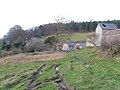 Cragend - geograph.org.uk - 306694.jpg 640 × 480; 89 KB
-
 Cragend Farm - geograph.org.uk - 2678358.jpg 2,000 × 1,500; 556 KB
-
 Cutting on Disused Railway Line - geograph.org.uk - 124430.jpg 640 × 480; 130 KB
-
 Cutting on Disused Railway line - geograph.org.uk - 124435.jpg 640 × 480; 164 KB
-

-
 Dried-out dam - geograph.org.uk - 2678367.jpg 2,000 × 1,500; 1 MB
-
 Farm buildings at Cragend - geograph.org.uk - 306699.jpg 640 × 480; 124 KB
-
 Field beside River Coquet - geograph.org.uk - 306404.jpg 640 × 480; 89 KB
-
 Field beside the Black Burn - geograph.org.uk - 306583.jpg 640 × 480; 77 KB
-
 Footbridge over Black Burn - geograph.org.uk - 306671.jpg 480 × 640; 126 KB
-
 Footpath to Healey - geograph.org.uk - 306421.jpg 640 × 480; 110 KB
-
 Haws and Hope Wood - geograph.org.uk - 306662.jpg 640 × 480; 143 KB
-
 Longhaugh - geograph.org.uk - 1431312.jpg 640 × 480; 98 KB
-
 Looking towards Cragend from near Healey - geograph.org.uk - 304837.jpg 640 × 480; 124 KB
-
 Muscovy duck aerobics - geograph.org.uk - 306720.jpg 640 × 358; 73 KB
-
 P309 This Pillbox number - geograph.org.uk - 1721919.jpg 3,000 × 4,000; 3.61 MB
-
 Pauperhaugh - geograph.org.uk - 928935.jpg 640 × 428; 80 KB
-
 Pillbox at Pauperhaugh - geograph.org.uk - 1721228.jpg 4,000 × 3,000; 5.37 MB
-
 River Coquet at Slidden Braes - geograph.org.uk - 304851.jpg 640 × 480; 130 KB
-
 River Coquet at Slidden Braes - geograph.org.uk - 306413.jpg 640 × 480; 152 KB
-
 Rocks beside drive near Cragend - geograph.org.uk - 306733.jpg 640 × 480; 115 KB
-
 The House on the hill across the river - geograph.org.uk - 1721926.jpg 4,000 × 3,000; 6.07 MB
-
 The lane from Healey - geograph.org.uk - 306398.jpg 640 × 480; 125 KB
-
 Tracks in the snow - geograph.org.uk - 1724476.jpg 4,000 × 3,000; 4.1 MB
-
 View across fields to Pillbox - geograph.org.uk - 1721922.jpg 4,000 × 3,000; 4.86 MB
-
 West Raw Farm - geograph.org.uk - 1427207.jpg 640 × 480; 70 KB
-
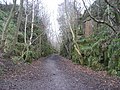
 Woodland beside Black Burn - geograph.org.uk - 306630.jpg 640 × 480; 158 KB


