Category:Piccadilly line
Jump to navigation
Jump to search
London Underground line   Maantieteellinen kartta linjasta. | |||||
| Upload media | |||||
| Instance of |
| ||||
|---|---|---|---|---|---|
| Named after | |||||
| Location | London Borough of Hammersmith and Fulham, Greater London, London, England | ||||
| Transport network | |||||
| Operator | |||||
| Date of official opening |
| ||||
| Significant event | |||||
| Length |
| ||||
| Terminus | |||||
| official website | |||||
| |||||
Subcategories
This category has the following 71 subcategories, out of 71 total.
1
A
- Acton Works (24 F)
- Arnos Park viaduct (57 F)
B
- Brompton Road tube station (76 F)
C
- Cockfosters Depot (4 F)
D
E
F
- Forestry House (12 F)
G
H
I
K
L
- Lillie Bridge Depot (10 F)
M
- Maps of the Piccadilly line (24 F)
N
- Northfields Depot (28 F)
O
P
R
S
T
U
W
Y
- York Road tube station (21 F)
Media in category "Piccadilly line"
The following 95 files are in this category, out of 95 total.
-
 Acton Green, Railway bridge over Fisher Lane - geograph.org.uk - 3140344.jpg 3,456 × 2,304; 6.22 MB
-
 Acton Works MMB 05.jpg 3,852 × 2,529; 5.6 MB
-
 At Eastcote tube station 2023 03.jpg 4,032 × 3,024; 4.88 MB
-
 At Eastcote tube station 2023 04.jpg 4,032 × 3,024; 4.49 MB
-
 At London 2023 033.jpg 4,032 × 3,024; 7.12 MB
-
 Bogie 1973 stock.JPG 2,272 × 1,704; 757 KB
-
 Bombs 7.7.05 Piccadilly line plaque.jpg 4,000 × 3,000; 4.66 MB
-

-
 Bridge at Turnham Green station - geograph.org.uk - 3828521.jpg 640 × 480; 117 KB
-
 Cambridge Grove - geograph.org.uk - 5129331.jpg 4,000 × 3,000; 3.43 MB
-
 CharingCrossStrandStations.png 1,077 × 871; 1.26 MB
-
 Cockfosters (1) 01.jpg 2,400 × 1,800; 2.84 MB
-
 Cockfosters (1) 02.jpg 2,400 × 1,800; 2.84 MB
-
 Cockfosters (1) 03.jpg 2,400 × 1,800; 2.96 MB
-
 Cockfosters (1) 04.jpg 2,400 × 1,800; 2.9 MB
-
 Cockfosters (1) 05.jpg 2,400 × 1,800; 2.88 MB
-
 Cockfosters (1) 06.jpg 2,400 × 1,800; 2.79 MB
-
 Cockfosters (1) 07.jpg 2,400 × 1,800; 2.84 MB
-
 Cockfosters (1) 08.jpg 2,400 × 1,800; 2.79 MB
-
 Cockfosters (1) 09.jpg 2,400 × 1,800; 2.86 MB
-
-

-

-

-
 Holborn Tube Station - Piccadilly Line - Eastbound Platform 4 - Line Map - July 2011.jpg 1,108 × 1,067; 124 KB
-
 Hounslow from the air - geograph.org.uk - 2245612.jpg 640 × 480; 201 KB
-
 Lampton Road - geograph.org.uk - 2245295.jpg 640 × 480; 145 KB
-
 Lampton Road - geograph.org.uk - 4547703.jpg 640 × 480; 158 KB
-
 Line to South Ealing - geograph.org.uk - 4049158.jpg 640 × 430; 82 KB
-
 London MMB «G3 15 Westferry Circus.jpg 3,945 × 2,592; 3.03 MB
-
 London MMB «I1 Kew Line.jpg 3,972 × 2,588; 4.42 MB
-
 London Piccadilly Line.png 200 × 48; 7 KB
-
 London Underground 1973 Stock train at Acton Town station.jpg 1,489 × 1,180; 490 KB
-
 London Underground subsurface and tube trains.jpg 1,425 × 925; 572 KB
-
 LU Acton Town junction.jpg 1,600 × 1,200; 946 KB
-
 Manor House UndergrounD Station. Green Lanes entrance.jpg 3,415 × 2,286; 1.41 MB
-

-

-
 New Southgate, Piccadilly Line viaduct - geograph.org.uk - 235804.jpg 640 × 480; 108 KB
-

-
 OIC Hounslow East tracks looking W.jpg 3,264 × 2,448; 3.08 MB
-
 Piccadilly (9538702044).jpg 1,808 × 2,543; 2.25 MB
-
 Piccadilly Line at River Crane bridge - geograph.org.uk - 3144494.jpg 640 × 480; 133 KB
-
 Piccadilly Line at South Ealing - geograph.org.uk - 837842.jpg 640 × 480; 100 KB
-

-

-
 Piccadilly line colour strip sign (roundel).svg 700 × 150; 13 KB
-
 Piccadilly line colour strip sign.svg 700 × 150; 9 KB
-
 Piccadilly Line from Northfield Avenue - geograph.org.uk - 837973.jpg 640 × 480; 123 KB
-
 Piccadilly Line heading for Sudbury Hill - geograph.org.uk - 3881464.jpg 2,304 × 1,728; 845 KB
-
 Piccadilly Line in Hounslow - geograph.org.uk - 2408754.jpg 640 × 469; 92 KB
-
 Piccadilly Line in Sudbury (1) - geograph.org.uk - 1650000.jpg 640 × 475; 84 KB
-
 Piccadilly Line in Sudbury (2) - geograph.org.uk - 1650053.jpg 640 × 487; 66 KB
-
 Piccadilly Line in Sudbury (3) - geograph.org.uk - 1651690.jpg 640 × 449; 85 KB
-
 Piccadilly Line in the suburbs - geograph.org.uk - 4328802.jpg 1,600 × 1,200; 533 KB
-
 Piccadilly Line indicator sign (51543109434).jpg 6,000 × 4,000; 6.71 MB
-
 Piccadilly Line railway at South Ealing - geograph.org.uk - 2700919.jpg 640 × 460; 103 KB
-

-

-
 Piccadilly Line Tube Train (27792513705).jpg 640 × 480; 462 KB
-
 Piccadilly Line ventilation shaft, Green Lanes - geograph.org.uk - 2819210.jpg 2,433 × 1,784; 3.31 MB
-
 Piccadilly Line viaduct - geograph.org.uk - 826774.jpg 640 × 480; 129 KB
-
 Piccadilly Line viaduct - geograph.org.uk - 967250.jpg 640 × 480; 114 KB
-

-
 Piccadily Line - panoramio.jpg 600 × 450; 22 KB
-

-
 Railway arch in Ravenscourt Park - geograph.org.uk - 5936812.jpg 4,646 × 3,702; 4.62 MB
-
 Railway bridge over Acton Lane - geograph.org.uk - 2643404.jpg 640 × 480; 126 KB
-
 Railway bridge over Kingsley Road - geograph.org.uk - 973752.jpg 640 × 480; 75 KB
-
 Railway Bridge, Turnham Green - geograph.org.uk - 4062908.jpg 640 × 430; 62 KB
-
 Railway line and sidings, Boston Manor - geograph.org.uk - 2249748.jpg 1,600 × 1,200; 581 KB
-
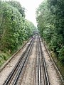
 Railway lines heading to Sudbury Town - geograph.org.uk - 3881429.jpg 2,304 × 1,728; 1.14 MB
-
 Railway lines looking towards Sudbury Town station - geograph.org.uk - 3881449.jpg 2,304 × 1,728; 812 KB
-

-
 Ravenscourt Road, London W6 - geograph.org.uk - 1616226.jpg 640 × 480; 62 KB
-
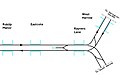 Rayners Lane track diagram.jpg 1,399 × 873; 103 KB
-
 Rayners Lane underground railway junction - geograph.org.uk - 82829.jpg 640 × 450; 100 KB
-
 Seldens Corner, Hammersmith - geograph.org.uk - 851358.jpg 640 × 480; 73 KB
-
 Step-free access notification (Piccadilly line).png 936 × 120; 16 KB
-
 Studland Street - geograph.org.uk - 1558095.jpg 640 × 480; 94 KB
-
 Sudbury Heights Ave - Footbridge - geograph.org.uk - 312548.jpg 640 × 480; 62 KB
-
 The Piccadilly Line - geograph.org.uk - 2279267.jpg 640 × 480; 197 KB
-
 The Piccadilly Line - geograph.org.uk - 2279272.jpg 640 × 480; 162 KB
-
 The Piccadilly Line - geograph.org.uk - 2692031.jpg 640 × 480; 206 KB
-
 The Piccadilly Line - geograph.org.uk - 4031754.jpg 640 × 430; 81 KB
-
 The Piccadilly Line between Ealing Common and Park Royal - geograph.org.uk - 2678712.jpg 1,600 × 1,200; 638 KB
-
 The Piccadilly Line heading towards Alperton - geograph.org.uk - 3881506.jpg 2,304 × 1,728; 862 KB
-

-
 Towards Boston Manor - geograph.org.uk - 301778.jpg 426 × 640; 124 KB
-
 Tube signs (10635444283).jpg 1,920 × 1,276; 758 KB
-
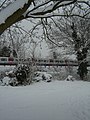 Tube train in snow.JPG 1,728 × 2,304; 1.7 MB
-
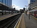 Uxbridge Tube Station platforms.jpg 4,160 × 3,120; 3.65 MB
-

-
 View from St Thomas's Church, London N14 - geograph.org.uk - 2927257.jpg 1,024 × 556; 299 KB
-


_01.jpg)
_02.jpg)
_03.jpg)
_04.jpg)
_05.jpg)
_06.jpg)
_07.jpg)
_08.jpg)
_09.jpg)


.jpg)


_-_geograph.org.uk_-_1650000.jpg)
_-_geograph.org.uk_-_1650053.jpg)
_-_geograph.org.uk_-_1651690.jpg)

.jpg)


.jpg)


_(14574732298).jpg)


.jpg)


.svg)
.png)