Category:Populated places in Gloucestershire
Jump to navigation
Jump to search
Wikimedia category | |||||
| Upload media | |||||
| Instance of | |||||
|---|---|---|---|---|---|
| Category combines topics | |||||
| Category contains | |||||
| Gloucestershire | |||||
ceremonial county in England (use Q21694733 for administrative non-metropolitan county) .jpg)   | |||||
| Instance of |
| ||||
| Location |
| ||||
| Capital | |||||
| Population |
| ||||
| Area |
| ||||
| Different from | |||||
| Said to be the same as | Gloucestershire (historic county of England, ceremonial county of England, 1844) | ||||
| official website | |||||
 | |||||
Ceremonial counties of England: Bedfordshire · Berkshire · Buckinghamshire · Cambridgeshire · Cheshire · Cornwall · Cumbria · Derbyshire · Devon · Dorset · Durham · East Riding of Yorkshire · East Sussex · Essex · Gloucestershire · Greater London · Greater Manchester · Hampshire · Herefordshire · Hertfordshire · Isle of Wight · Kent · Lancashire · Leicestershire · Lincolnshire · Merseyside · Norfolk · North Yorkshire · Northamptonshire · Northumberland · Nottinghamshire · Oxfordshire · Rutland · Shropshire · Somerset · South Yorkshire · Staffordshire · Suffolk · Surrey · Tyne and Wear · Warwickshire · West Midlands · West Sussex · West Yorkshire · Wiltshire · Worcestershire
City-counties:
Former historic counties: Huntingdonshire · Yorkshire
Other former counties:
City-counties:
Former historic counties: Huntingdonshire · Yorkshire
Other former counties:
Subcategories
This category has the following 4 subcategories, out of 4 total.
Media in category "Populated places in Gloucestershire"
The following 25 files are in this category, out of 25 total.
-
 A view down Cooper's Hill.jpg 1,716 × 1,171; 882 KB
-
 CashesGreenGlos.jpg 1,986 × 1,413; 714 KB
-
 CheeseMaster (cropped).jpg 355 × 359; 25 KB
-
 CheeseMaster.jpg 640 × 480; 53 KB
-
 CheeseRolling.jpg 1,509 × 1,070; 463 KB
-
 CheeseRollingRace.jpg 600 × 441; 88 KB
-
 Cleeve Hill village (4971).jpg 4,288 × 2,848; 5.86 MB
-
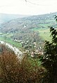 Looking down on Brockweir - geograph.org.uk - 707595.jpg 436 × 639; 68 KB
-
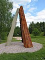 New Fancy sculpture.jpg 480 × 640; 194 KB
-
 Newnham - geograph.org.uk - 683318.jpg 640 × 480; 95 KB
-
 Newnham through the wire - geograph.org.uk - 574973.jpg 640 × 391; 44 KB
-
 Old School House Churchdown UK.JPG 2,048 × 1,536; 790 KB
-
 Pamington - geograph.org.uk - 710236.jpg 640 × 426; 82 KB
-
 Parkend village.jpg 3,056 × 2,292; 1.02 MB
-
 Phone box and postbox at Stowfield - geograph.org.uk - 764359.jpg 640 × 458; 136 KB
-
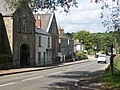
 Preston Street, Cotswolds - geograph.org.uk - 22364.jpg 640 × 480; 182 KB
-
 Withybridge.jpg 480 × 640; 79 KB
-
 Christmas-tree-in-the-water - geograph.org.uk - 289464.jpg 640 × 427; 96 KB
-
 High Street, Saul - geograph.org.uk - 103361.jpg 1,600 × 1,200; 1.11 MB
-
 Littledean from Dockham - geograph.org.uk - 132521.jpg 640 × 479; 50 KB
-
 Main road through Newnham - geograph.org.uk - 289748.jpg 640 × 427; 65 KB
-
 Newnham on Severn - geograph.org.uk - 9393.jpg 640 × 480; 168 KB
-
 Site of Roman settlement - geograph.org.uk - 466031.jpg 640 × 477; 86 KB
-
 Village pub, sign, waste bin, and bench. - geograph.org.uk - 305050.jpg 640 × 480; 121 KB
-
 Whiteshill village - geograph.org.uk - 162048.jpg 640 × 480; 130 KB


.jpg)


.jpg)


