Category:QGIS
Jump to navigation
Jump to search
Thanks to use {{Created with QGIS}}) for all images made with the software, using this general category for other pertinent documents and images to the software itself.
open source desktop geographic information system software  QGIS 2.2 Valmiera a Ubuntu 13.10. | |||||
| Upload media | |||||
| Pronunciation audio | |||||
|---|---|---|---|---|---|
| Instance of |
| ||||
| Distribution format | |||||
| Copyright license |
| ||||
| Has use | |||||
| Collection |
| ||||
| Developer |
| ||||
| Platform |
| ||||
| Operating system | |||||
| Software version identifier |
| ||||
| Inception |
| ||||
| Sponsor |
| ||||
| user manual URL | |||||
| official website | |||||
| |||||
Media in category "QGIS"
The following 98 files are in this category, out of 98 total.
-
 Active COVID-19 Cases in Davao City during ECQ.png 3,531 × 5,090; 2.7 MB
-
 Carte du voyage de Nicolas Bouvier dans L'Usage du monde.jpg 3,507 × 1,688; 811 KB
-
 Configuración de estilo de confidencialidad en QGIS.png 1,874 × 1,728; 677 KB
-
 Creating maps with Qgis.svg 2,302 × 1,723; 2.2 MB
-
 Cumulative Cases Colored.gif 849 × 1,200; 4.39 MB
-
 Exportar estilo SLD en QGIS.png 1,206 × 1,338; 426 KB
-
 FOSSGIS 2017 Neues von QGIS.jpg 2,592 × 3,888; 3.29 MB
-
 Infografía de transecto Cabo Peñas Jerte.jpg 4,000 × 2,014; 854 KB
-
 Infografía de transecto Pirineos Delta del Ebro.jpg 4,000 × 2,014; 826 KB
-
 Karten erstellen mit QGIS Slides.pdf 2,000 × 1,125, 7 pages; 878 KB
-
 Liaison QGIS avec les bases de données.png 716 × 406; 22 KB
-
 Location maps-Simple SVG-01.png 1,366 × 768; 157 KB
-
Map projections and distortions.webm 5 min 4 s, 1,920 × 1,080; 12.34 MB
-
 Modelo 3D de Gran Canaria Islas Canarias.stl 5,120 × 2,880; 102.58 MB
-
 Modelo 3D de la Isla Atlasov.stl 5,120 × 2,880; 85.8 MB
-
 Modelo 3D de São Miguel Islas Azores.stl 5,120 × 2,880; 105.77 MB
-
 Modelo 3D de Tenerife, Islas Canarias.stl 5,120 × 2,880; 198.17 MB
-
 Modelo 3D del Aconcagua.stl 5,120 × 2,880; 323.83 MB
-
 Modelo 3D del Ama Dablam.stl 5,120 × 2,880; 129.15 MB
-
 Naturalearth vs SWBD vs OpenStreetMap.svg 1,677 × 1,007; 570 KB
-
 OpenStreetMap QGIS attribute table.png 3,566 × 3,286; 1.32 MB
-
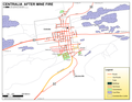 PA CENTRALIA NEW.PNG 3,300 × 2,550; 420 KB
-
 PA CENTRALIA OLD b.jpg 3,300 × 2,550; 2.86 MB
-
 PA CENTRALIA OLD.PNG 3,300 × 2,550; 388 KB
-
 Print composer in QGIS.png 1,153 × 688; 138 KB
-
 Przykład kwerendy w oprogramowaniu QGIS.jpg 1,924 × 1,026; 361 KB
-
 PyQgis Logo Illustration.png 1,440 × 855; 47 KB
-
LL-Q7737 (rus)-Svetlov Artem-QGIS.wav 1.2 s; 115 KB
-
 QGIS 3.36 Maidenhead UI.png 1,920 × 1,040; 415 KB
-
 QGIS AtmosphericCorrectionConversionTOA.jpg 1,366 × 768; 314 KB
-
 QGIS buttons-fr.png 3,428 × 2,253; 649 KB
-
 QGIS Colormap Problem 2.0.png 1,920 × 1,040; 482 KB
-
 QGIS FinishedNDVIlayer.jpg 1,366 × 768; 264 KB
-
 QGIS ImplementMaps.jpg 1,366 × 768; 288 KB
-
 QGIS InstallPlugin.jpg 1,366 × 768; 475 KB
-
 QGIS Interface Screenshot with Map of Median Income in Houston (2010).png 2,610 × 1,464; 986 KB
-
 QGIS Label style editor.png 1,680 × 1,005; 209 KB
-
 QGIS LayerProperties.jpg 1,366 × 768; 284 KB
-
 QGIS logo Georgia.svg 256 × 256; 5 KB
-
 QGIS logo minimal.svg 128 × 128; 2 KB
-
 QGIS logo new.svg 256 × 256; 3 KB
-
 QGIS logo, 2017.svg 534 × 159; 6 KB
-
 QGis Logo.png 1,600 × 1,763; 265 KB
-
 QGIS logo.svg 59 × 56; 15 KB
-
 Qgis mActionAddOgrLayer.svg 32 × 32; 10 KB
-
 Qgis mActionAddRasterLayer.svg 24 × 24; 9 KB
-
 QGIS Map Depicting Roads, Highways, and Schools in Houston.png 2,516 × 1,536; 3.03 MB
-
 Qgis milano tradevalue 180911.jpg 1,920 × 1,080; 1.13 MB
-
 QGIS Point Style Editor.png 1,680 × 1,005; 240 KB
-
 QGIS Polygonizer tutorial 0.png 1,680 × 1,010; 171 KB
-
 QGIS polygonizer tutorial 1.png 1,680 × 1,011; 181 KB
-
 QGIS polygonizer tutorial 2.png 1,680 × 1,011; 175 KB
-
 QGIS Polygonizer tutorial 3.png 1,680 × 1,010; 204 KB
-
 QGIS Polygonizer tutorial 4.png 1,680 × 1,010; 184 KB
-
 QGIS PrintComposer.jpg 1,366 × 768; 336 KB
-
 QGIS RasterCalculator.jpg 1,366 × 768; 310 KB
-
 QGIS screen shot showing plug-in interface in dutch.png 1,303 × 744; 229 KB
-
 QGis SimpleSVG 01 - field for items names.png 924 × 653; 156 KB
-
 QGIS Software Interface.png 2,510 × 1,538; 451 KB
-
 QGIS style editor 1.png 1,680 × 1,004; 240 KB
-
 QGIS style editor 2.png 1,680 × 1,003; 257 KB
-
 QGIS with OSM and Safecast data.png 1,280 × 994; 551 KB
-
 QGIS-Android GPS information.png 1,280 × 800; 203 KB
-
 QGIS-Android layer style menu.png 1,280 × 800; 92 KB
-
 QGIS-Android options screenshot.png 1,280 × 800; 99 KB
-
 QGIS-Android screenshot2.png 1,280 × 800; 208 KB
-
 QGIS-Android screenshot3.png 1,280 × 800; 182 KB
-
 Qgis-icon-3.0.png 328 × 315; 15 KB
-
 QGis-tuto-composeur-cadastre.PNG 1,537 × 868; 667 KB
-
 QGis-tuto-composeur-géologie.PNG 1,527 × 867; 589 KB
-
 QGis-tuto-composeur-Natura.PNG 1,537 × 865; 382 KB
-
 QGis-tuto-composeur-routes-hydro.PNG 1,537 × 866; 328 KB
-
 QGis-tuto-composeur-sols.PNG 1,535 × 857; 373 KB
-
 QGis-tuto-composeur-znieff.PNG 1,529 × 860; 428 KB
-
 QGis-tuto-composeur.PNG 1,445 × 861; 1.15 MB
-
 QGis-tuto-couche-communes.PNG 1,054 × 763; 74 KB
-
 QGis-tuto-ecran-Natura.PNG 1,690 × 1,042; 584 KB
-
 QGis-tuto-ecran-ppal-Cadastre.PNG 1,664 × 1,037; 1.04 MB
-
 QGis-tuto-ecran-ppal-géologie.PNG 1,841 × 1,038; 812 KB
-
 QGis-tuto-ecran-ppal-Hydro-Routes.PNG 1,650 × 1,041; 647 KB
-
 QGis-tuto-ecran-ppal-sols.PNG 1,736 × 1,053; 615 KB
-
 QGis-tuto-ecran-znieff.PNG 1,719 × 1,040; 656 KB
-
 QGis-tuto-etiquettes.PNG 804 × 320; 19 KB
-
 QGis-tuto-feuille-style-geologie.PNG 1,059 × 768; 83 KB
-
 QGis-tuto-ortho-ecran-ppal.PNG 1,887 × 1,039; 2.14 MB
-
 RA XXXII - Sol Nascente - Pôr do Sol - Equipamentos Públicos.png 2,000 × 1,414; 1.72 MB
-
 RA XXXII - Sol Nascente - Pôr do Sol - Segurança Pública.png 3,507 × 2,480; 4.2 MB
-
 Semnozcentral (42179335215).png 1,122 × 793; 1.24 MB
-
 SENTINEL2-Petrolina.png 1,280 × 1,024; 311 KB
-
 SPARQLing Unicorn QGIS Plugin Ogham.png 1,920 × 1,038; 862 KB
-
 Survey of Italian military strucutres near to Col Rosson.jpg 1,500 × 998; 308 KB
-
 Survey of Italian military strucutres on the ridge between Col Quaternà e Col Rosson.jpg 1,061 × 1,500; 299 KB
-
Survol en rotation autour du massif de Coutach.webm 50 s, 1,920 × 1,080; 13.65 MB
-
 Tuto QGIS Composeur 2.svg 1,680 × 1,007; 210 KB
-
 Tutorial QGIS print composeur buttons-fr.png 3,360 × 2,010; 227 KB
-
 Tutorial vector topo map es 07.png 1,009 × 719; 172 KB
-
 Weekly Active COVID-19 Cases in Davao City.gif 849 × 1,200; 4.25 MB
-
 Étapes de création de carte avec QGIS.svg 512 × 383; 608 KB


.png)


.png)


