Category:Raneh Falls
Jump to navigation
Jump to search
waterfall  | |||||
| Upload media | |||||
| Instance of | |||||
|---|---|---|---|---|---|
| Part of | |||||
| Location | Chhatarpur district, Sagar division, Madhya Pradesh, India | ||||
| Drainage basin | |||||
 | |||||
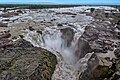
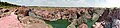
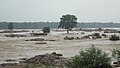
Raneh falls are a series of waterfalls on the Ken River, located about 20 kilometers radially northeast of Khajuraho, Madhya Pradesh. They illustrate the hilly, river carved terrain of Bundelkhand, one punctuated by fertile valleys. The Raneh falls stretch over 5 kilometer along the river and form a 100 feet deep canyon. The water and mist washes over the pink, red and grey granite. The major falls run year round and are a short drive from the Khajuraho UNESCO world heritage site. The smaller ones appear in and after the monsoons for several months, and are along a hiking trail.
Media in category "Raneh Falls"
The following 17 files are in this category, out of 17 total.
-
 Canyon Of Raneh Falls (March 2015).jpg 2,448 × 3,264; 3.16 MB
-
 Raneh Fall - Natural Water Fall.jpg 5,184 × 3,456; 10.52 MB
-
 Raneh Falls (March 2015).jpg 3,264 × 2,448; 3.93 MB
-
 Raneh Falls Ken river (2108033869).jpg 1,024 × 768; 199 KB
-
 Raneh Falls Ken river (2108808380).jpg 768 × 1,024; 156 KB
-
 Raneh falls MP, India.jpg 2,432 × 1,920; 950 KB
-
 Raneh falls, Madhya Pradesh 11.jpg 4,400 × 3,001; 2.38 MB
-
 Raneh falls, Madhya Pradesh 17.jpg 4,400 × 2,933; 2.61 MB
-
 Raneh falls, Madhya Pradesh 32.jpg 4,400 × 2,933; 2.86 MB
-
 Raneh falls, Madhya Pradesh 55.jpg 4,400 × 2,933; 2.99 MB
-
 Raneh Falls.jpg 4,608 × 2,592; 1.72 MB
-
 Raneh falls.jpg 15,898 × 3,670; 26.53 MB
-
 Raneh Waterfall Madhya Pradesh India Fall View.jpg 3,264 × 2,448; 1.65 MB
-
 Raneh Waterfall Madhya Pradesh India River Flow.jpg 3,264 × 2,448; 3.32 MB
-
 Raneh Waterfall Madhya Pradesh India.jpg 3,264 × 2,448; 1.8 MB
-
 Strata at Raneh Falls (2015).jpg 2,448 × 3,264; 2.29 MB
-
 Strong rooted in the middle of violent Ken.JPG 4,320 × 2,432; 2.97 MB
.jpg)

.jpg)
.jpg)
.jpg)


.jpg)
