Category:Risbury
Jump to navigation
Jump to search

village in Herefordshire, England, UK | |||||
| Upload media | |||||
| Instance of | |||||
|---|---|---|---|---|---|
| Location | Humber, Herefordshire, West Midlands, England | ||||
 | |||||
English: Risbury is a small village in the civil parish of Humber, in Herefordshire, England, and is 4 miles south-east of Leominster. (→Risbury)
Subcategories
This category has the following 2 subcategories, out of 2 total.
R
- Risbury Camp (6 F)
- Risbury Methodist Church (2 F)
Media in category "Risbury"
The following 25 files are in this category, out of 25 total.
-

-
 A wheat field near Risbury - geograph.org.uk - 4497860.jpg 800 × 531; 152 KB
-
 Avenue - geograph.org.uk - 281254.jpg 640 × 427; 338 KB
-
 Cottage in Risbury - geograph.org.uk - 4497254.jpg 800 × 531; 134 KB
-
 Former school in Risbury - geograph.org.uk - 4497268.jpg 1,024 × 680; 310 KB
-
 Geese on the Humber Brook, Risbury - geograph.org.uk - 280995.jpg 640 × 427; 314 KB
-
 Herefords, Risbury - geograph.org.uk - 280978.jpg 640 × 427; 279 KB
-
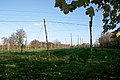 Hop Field in November - geograph.org.uk - 281272.jpg 640 × 427; 276 KB
-
 Hop Poles, Risbury - geograph.org.uk - 280977.jpg 640 × 427; 338 KB
-
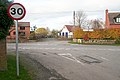
 Leaving Risbury Eastward - geograph.org.uk - 1235600.jpg 640 × 480; 204 KB
-
 Meadow By Humber Brook - geograph.org.uk - 1235169.jpg 640 × 480; 275 KB
-
 Risbury - Fields Before New House Farm - geograph.org.uk - 1235194.jpg 640 × 480; 163 KB
-
 Risbury - The Lane South - geograph.org.uk - 1235203.jpg 640 × 480; 230 KB
-
 Risbury Telephone Box - geograph.org.uk - 1235188.jpg 640 × 480; 226 KB
-
 Risbury Village Hall - geograph.org.uk - 1235222.jpg 640 × 480; 151 KB
-
 Risbury Village Hall - geograph.org.uk - 4497270.jpg 800 × 531; 133 KB
-
 Upper House, Risbury - geograph.org.uk - 4497240.jpg 800 × 531; 151 KB
-
 Fields east of Risbury - geograph.org.uk - 44272.jpg 640 × 480; 161 KB
-

-
 Moss Covered Stumps - geograph.org.uk - 281276.jpg 427 × 640; 378 KB
-
 New House Farm trig - geograph.org.uk - 249933.jpg 640 × 480; 140 KB
-
 Orchard, Upper House. - geograph.org.uk - 146676.jpg 640 × 480; 119 KB
-
 Risbury Cross - geograph.org.uk - 280990.jpg 640 × 427; 260 KB
-
 Risbury School - geograph.org.uk - 280984.jpg 640 × 427; 335 KB
-
 Upper House. - geograph.org.uk - 146683.jpg 640 × 480; 82 KB


