Category:Rotes Luch
Jump to navigation
Jump to search
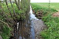
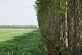
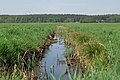
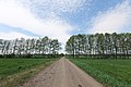
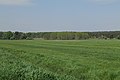
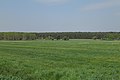
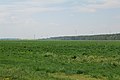
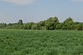
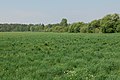
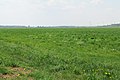
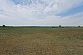
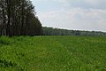
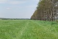
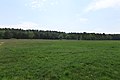
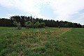
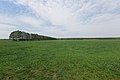
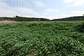
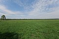
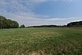
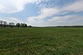
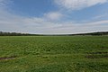
Deutsch: Das Rote Luch ist ein Niedermoorgebiet in der Brandenburger Märkischen Schweiz und im Naturpark Märkische Schweiz. Das im 19. Jahrhundert trockengelegte Wiesengebiet bildet die Nordsee-Ostsee-Wasserscheide und ist Quellgebiet (Pseudobifukation) des Stobber, der nach Nordwesten über den Friedländer Strom, die Alte Oder, die Hohensaaten-Friedrichsthaler Wasserstraße und die Oder zur Ostsee entwässert; ferner Quellgebiet des Stobberbachs, der nach Südwesten über Löcknitz, Spree, Havel und Elbe zur Nordsee entwässert.
English: The Rotes Luch is a fen area in the hill country „Märkische Schweiz“ and the Märkische Schweiz Nature Park, Brandenburg, Germany. The in the 19th century drained grassland is the Drainage divide (River bifurcation) and the river source for the Stobber (towards northeast, Baltic Sea) and Stobberbach (towards southwest, North Sea).
fen area in Brandenburg, Germany  | |||||
| Upload media | |||||
| Instance of | |||||
|---|---|---|---|---|---|
| Location | Brandenburg, Germany | ||||
| Elevation above sea level |
| ||||
 | |||||
Media in category "Rotes Luch"
The following 198 files are in this category, out of 198 total.
-
 Anas platyrhynchos in Rotes Luch Märkische Schweiz 2022-05-11 01.jpg 8,368 × 5,584; 12.92 MB
-
 Anas platyrhynchos in Rotes Luch Märkische Schweiz 2022-05-11 02.jpg 8,368 × 5,584; 12.79 MB
-
 Bf Rotes Luch.JPG 5,184 × 3,456; 8.74 MB
-
 Ditch in Rotes Luch Märkische Schweiz 2022-05-11 01.jpg 8,368 × 5,584; 23.88 MB
-
 Ditch in Rotes Luch Märkische Schweiz 2022-05-11 02.jpg 8,368 × 5,584; 24.95 MB
-
 Ditch in Rotes Luch Märkische Schweiz 2022-05-11 03.jpg 8,368 × 5,584; 24.31 MB
-
 Ditch in Rotes Luch Märkische Schweiz 2022-05-11 04.jpg 5,584 × 8,368; 23.59 MB
-
 Ditch in Rotes Luch Märkische Schweiz 2022-05-11 05.jpg 8,368 × 5,584; 23.84 MB
-
 Ditch in Rotes Luch Märkische Schweiz 2022-05-11 06.jpg 8,368 × 5,584; 22.94 MB
-
 Ditch in Rotes Luch Märkische Schweiz 2022-05-11 07.jpg 8,368 × 5,584; 23.92 MB
-
 Ditch in Rotes Luch Märkische Schweiz 2022-05-11 08.jpg 8,368 × 5,584; 22.63 MB
-
 Ditch in Rotes Luch Märkische Schweiz 2022-05-11 09.jpg 8,368 × 5,584; 22.67 MB
-
 Ditch in Rotes Luch Märkische Schweiz 2022-05-11 10.jpg 8,368 × 5,584; 24.75 MB
-
 Ditch in Rotes Luch Märkische Schweiz 2022-05-11 11.jpg 8,368 × 5,584; 20.89 MB
-
 Ditch in Rotes Luch Märkische Schweiz 2022-05-11 12.jpg 8,368 × 5,584; 24.53 MB
-
 Ditch in Rotes Luch Märkische Schweiz 2022-05-11 13.jpg 8,368 × 5,584; 25.09 MB
-
 Ditch in Rotes Luch Märkische Schweiz 2022-05-11 14.jpg 8,368 × 5,584; 23.2 MB
-
 Ditch in Rotes Luch Märkische Schweiz 2022-05-11 15.jpg 8,368 × 5,584; 23.4 MB
-
 Ditch in Rotes Luch Märkische Schweiz 2022-05-11 16.jpg 8,368 × 5,584; 23.04 MB
-
 Ditch in Rotes Luch Märkische Schweiz 2022-05-11 17.jpg 8,368 × 5,584; 22.88 MB
-
 Ditch in Rotes Luch Märkische Schweiz 2022-05-11 18.jpg 8,368 × 5,584; 23.26 MB
-
 Ditch in Rotes Luch Märkische Schweiz 2022-05-11 19.jpg 8,368 × 5,584; 24.39 MB
-
 Ditch in Rotes Luch Märkische Schweiz 2022-05-11 20.jpg 8,368 × 5,584; 23.08 MB
-
 Ditch in Rotes Luch Märkische Schweiz 2022-05-11 21.jpg 8,368 × 5,584; 22.97 MB
-
 LuchAviation.jpg 2,048 × 3,072; 2.42 MB
-
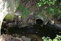
 LuchFloodGate.jpg 1,937 × 2,627; 4.4 MB
-
 Rotes Luch 01.jpg 3,533 × 2,650; 3.45 MB
-
 Rotes Luch 02.jpg 3,488 × 2,580; 3.62 MB
-
 Rotes Luch 03.jpg 3,488 × 2,580; 4.25 MB
-
 Rotes Luch 04.jpg 3,533 × 2,650; 3.88 MB
-
 Rotes Luch bei Werder (1).jpg 4,032 × 3,024; 2.04 MB
-
 Rotes Luch bei Werder (2).jpg 4,032 × 3,024; 3.9 MB
-
 Rotes Luch bei Werder (3).jpg 4,032 × 3,024; 2.09 MB
-
 Rotes Luch bei Werder.jpg 14,028 × 3,918; 12.13 MB
-
 Rotes Luch Märkische Schweiz 2022-05-11 01.jpg 8,368 × 5,584; 22.6 MB
-
 Rotes Luch Märkische Schweiz 2022-05-11 02.jpg 8,368 × 5,584; 24.69 MB
-
 Rotes Luch Märkische Schweiz 2022-05-11 03.jpg 8,368 × 5,584; 22.92 MB
-
 Rotes Luch Märkische Schweiz 2022-05-11 04.jpg 8,368 × 5,584; 21.64 MB
-
 Rotes Luch Märkische Schweiz 2022-05-11 05.jpg 8,368 × 5,584; 20.53 MB
-
 Rotes Luch Märkische Schweiz 2022-05-11 06.jpg 8,368 × 5,584; 20.05 MB
-
 Rotes Luch Märkische Schweiz 2022-05-11 07.jpg 8,368 × 5,584; 22.2 MB
-
 Rotes Luch Märkische Schweiz 2022-05-11 08.jpg 8,368 × 5,584; 20.23 MB
-
 Rotes Luch Märkische Schweiz 2022-05-11 09.jpg 8,368 × 5,584; 19.03 MB
-
 Rotes Luch Märkische Schweiz 2022-05-11 10.jpg 8,368 × 5,584; 20.87 MB
-
 Rotes Luch Märkische Schweiz 2022-05-11 100.jpg 8,368 × 5,584; 23.01 MB
-
 Rotes Luch Märkische Schweiz 2022-05-11 101.jpg 8,368 × 5,584; 23.52 MB
-
 Rotes Luch Märkische Schweiz 2022-05-11 102.jpg 8,368 × 5,584; 23.68 MB
-
 Rotes Luch Märkische Schweiz 2022-05-11 103.jpg 8,368 × 5,584; 23.14 MB
-
 Rotes Luch Märkische Schweiz 2022-05-11 104.jpg 8,368 × 5,584; 22.52 MB
-
 Rotes Luch Märkische Schweiz 2022-05-11 105.jpg 8,368 × 5,584; 22.89 MB
-
 Rotes Luch Märkische Schweiz 2022-05-11 106.jpg 8,368 × 5,584; 23.01 MB
-
 Rotes Luch Märkische Schweiz 2022-05-11 107.jpg 8,368 × 5,584; 23.27 MB
-
 Rotes Luch Märkische Schweiz 2022-05-11 108.jpg 8,368 × 5,584; 20.89 MB
-
 Rotes Luch Märkische Schweiz 2022-05-11 109.jpg 8,368 × 5,584; 22 MB
-
 Rotes Luch Märkische Schweiz 2022-05-11 11.jpg 8,368 × 5,584; 20.95 MB
-
 Rotes Luch Märkische Schweiz 2022-05-11 110.jpg 8,368 × 5,584; 21.41 MB
-
 Rotes Luch Märkische Schweiz 2022-05-11 111.jpg 8,368 × 5,584; 21.8 MB
-
 Rotes Luch Märkische Schweiz 2022-05-11 112.jpg 8,368 × 5,584; 22.96 MB
-
 Rotes Luch Märkische Schweiz 2022-05-11 113.jpg 8,368 × 5,584; 21.62 MB
-
 Rotes Luch Märkische Schweiz 2022-05-11 114.jpg 8,368 × 5,584; 23.17 MB
-
 Rotes Luch Märkische Schweiz 2022-05-11 115.jpg 8,368 × 5,584; 22.84 MB
-
 Rotes Luch Märkische Schweiz 2022-05-11 116.jpg 8,368 × 5,584; 22.61 MB
-
 Rotes Luch Märkische Schweiz 2022-05-11 117.jpg 8,368 × 5,584; 22.35 MB
-
 Rotes Luch Märkische Schweiz 2022-05-11 118.jpg 8,368 × 5,584; 23.18 MB
-
 Rotes Luch Märkische Schweiz 2022-05-11 119.jpg 8,368 × 5,584; 22.87 MB
-
 Rotes Luch Märkische Schweiz 2022-05-11 12.jpg 8,368 × 5,584; 19.95 MB
-
 Rotes Luch Märkische Schweiz 2022-05-11 120.jpg 8,368 × 5,584; 22.76 MB
-
 Rotes Luch Märkische Schweiz 2022-05-11 121.jpg 8,368 × 5,584; 19.93 MB
-
 Rotes Luch Märkische Schweiz 2022-05-11 122.jpg 8,368 × 5,584; 23.19 MB
-
 Rotes Luch Märkische Schweiz 2022-05-11 123.jpg 8,368 × 5,584; 22.49 MB
-
 Rotes Luch Märkische Schweiz 2022-05-11 124.jpg 8,368 × 5,584; 22.72 MB
-
 Rotes Luch Märkische Schweiz 2022-05-11 125.jpg 8,368 × 5,584; 19.98 MB
-
 Rotes Luch Märkische Schweiz 2022-05-11 126.jpg 8,368 × 5,584; 19.66 MB
-
 Rotes Luch Märkische Schweiz 2022-05-11 127.jpg 8,368 × 5,584; 22.43 MB
-
 Rotes Luch Märkische Schweiz 2022-05-11 128.jpg 8,368 × 5,584; 22.91 MB
-
 Rotes Luch Märkische Schweiz 2022-05-11 129.jpg 8,368 × 5,584; 23.38 MB
-
 Rotes Luch Märkische Schweiz 2022-05-11 13.jpg 8,368 × 5,584; 21.61 MB
-
 Rotes Luch Märkische Schweiz 2022-05-11 130.jpg 8,368 × 5,584; 22.52 MB
-
 Rotes Luch Märkische Schweiz 2022-05-11 131.jpg 8,368 × 5,584; 20.64 MB
-
 Rotes Luch Märkische Schweiz 2022-05-11 132.jpg 8,368 × 5,584; 23.83 MB
-
 Rotes Luch Märkische Schweiz 2022-05-11 133.jpg 8,368 × 5,584; 22.88 MB
-
 Rotes Luch Märkische Schweiz 2022-05-11 134.jpg 8,368 × 5,584; 21.26 MB
-
 Rotes Luch Märkische Schweiz 2022-05-11 135.jpg 8,368 × 5,584; 22.8 MB
-
 Rotes Luch Märkische Schweiz 2022-05-11 136.jpg 8,368 × 5,584; 22.31 MB
-
 Rotes Luch Märkische Schweiz 2022-05-11 137.jpg 8,368 × 5,584; 22.17 MB
-
 Rotes Luch Märkische Schweiz 2022-05-11 138.jpg 8,368 × 5,584; 22.8 MB
-
 Rotes Luch Märkische Schweiz 2022-05-11 139.jpg 8,368 × 5,584; 22.79 MB
-
 Rotes Luch Märkische Schweiz 2022-05-11 14.jpg 8,368 × 5,584; 22.9 MB
-
 Rotes Luch Märkische Schweiz 2022-05-11 140.jpg 8,368 × 5,584; 22.63 MB
-
 Rotes Luch Märkische Schweiz 2022-05-11 141.jpg 8,368 × 5,584; 20.59 MB
-
 Rotes Luch Märkische Schweiz 2022-05-11 142.jpg 8,368 × 5,584; 20.04 MB
-
 Rotes Luch Märkische Schweiz 2022-05-11 143.jpg 8,368 × 5,584; 22.11 MB
-
 Rotes Luch Märkische Schweiz 2022-05-11 144.jpg 8,368 × 5,584; 23.26 MB
-
 Rotes Luch Märkische Schweiz 2022-05-11 145.jpg 8,368 × 5,584; 23.22 MB
-
 Rotes Luch Märkische Schweiz 2022-05-11 146.jpg 8,368 × 5,584; 22.06 MB
-
 Rotes Luch Märkische Schweiz 2022-05-11 147.jpg 8,368 × 5,584; 19.73 MB
-
 Rotes Luch Märkische Schweiz 2022-05-11 148.jpg 8,368 × 5,584; 22.09 MB
-
 Rotes Luch Märkische Schweiz 2022-05-11 149.jpg 8,368 × 5,584; 22.55 MB
-
 Rotes Luch Märkische Schweiz 2022-05-11 15.jpg 8,368 × 5,584; 22.32 MB
-
 Rotes Luch Märkische Schweiz 2022-05-11 150.jpg 8,368 × 5,584; 23.94 MB
-
 Rotes Luch Märkische Schweiz 2022-05-11 151.jpg 8,368 × 5,584; 23.49 MB
-
 Rotes Luch Märkische Schweiz 2022-05-11 152.jpg 8,368 × 5,584; 23.05 MB
-
 Rotes Luch Märkische Schweiz 2022-05-11 153.jpg 8,368 × 5,584; 22.9 MB
-
 Rotes Luch Märkische Schweiz 2022-05-11 154.jpg 8,368 × 5,584; 16.76 MB
-
 Rotes Luch Märkische Schweiz 2022-05-11 155.jpg 8,368 × 5,584; 16.66 MB
-
 Rotes Luch Märkische Schweiz 2022-05-11 156.jpg 8,368 × 5,584; 15.04 MB
-
 Rotes Luch Märkische Schweiz 2022-05-11 157.jpg 8,368 × 5,584; 15.08 MB
-
 Rotes Luch Märkische Schweiz 2022-05-11 158.jpg 8,368 × 5,584; 14.38 MB
-
 Rotes Luch Märkische Schweiz 2022-05-11 16.jpg 8,368 × 5,584; 22.79 MB
-
 Rotes Luch Märkische Schweiz 2022-05-11 17.jpg 8,368 × 5,584; 23.38 MB
-
 Rotes Luch Märkische Schweiz 2022-05-11 18.jpg 8,368 × 5,584; 22.79 MB
-
 Rotes Luch Märkische Schweiz 2022-05-11 19.jpg 8,368 × 5,584; 23.36 MB
-
 Rotes Luch Märkische Schweiz 2022-05-11 20.jpg 8,368 × 5,584; 22.04 MB
-
 Rotes Luch Märkische Schweiz 2022-05-11 21.jpg 8,368 × 5,584; 22.98 MB
-
 Rotes Luch Märkische Schweiz 2022-05-11 22.jpg 8,368 × 5,584; 22.2 MB
-
 Rotes Luch Märkische Schweiz 2022-05-11 23.jpg 8,368 × 5,584; 22.98 MB
-
 Rotes Luch Märkische Schweiz 2022-05-11 24.jpg 8,368 × 5,584; 24.58 MB
-
 Rotes Luch Märkische Schweiz 2022-05-11 25.jpg 8,368 × 5,584; 23.43 MB
-
 Rotes Luch Märkische Schweiz 2022-05-11 26.jpg 8,368 × 5,584; 23.21 MB
-
 Rotes Luch Märkische Schweiz 2022-05-11 27.jpg 8,368 × 5,584; 22.64 MB
-
 Rotes Luch Märkische Schweiz 2022-05-11 28.jpg 8,368 × 5,584; 22.59 MB
-
 Rotes Luch Märkische Schweiz 2022-05-11 29.jpg 8,368 × 5,584; 23.19 MB
-
 Rotes Luch Märkische Schweiz 2022-05-11 30.jpg 8,368 × 5,584; 21.88 MB
-
 Rotes Luch Märkische Schweiz 2022-05-11 31.jpg 8,368 × 5,584; 22.84 MB
-
 Rotes Luch Märkische Schweiz 2022-05-11 32.jpg 8,368 × 5,584; 22.89 MB
-
 Rotes Luch Märkische Schweiz 2022-05-11 33.jpg 8,368 × 5,584; 22.71 MB
-
 Rotes Luch Märkische Schweiz 2022-05-11 34.jpg 8,368 × 5,584; 23.2 MB
-
 Rotes Luch Märkische Schweiz 2022-05-11 35.jpg 8,368 × 5,584; 22.32 MB
-
 Rotes Luch Märkische Schweiz 2022-05-11 36.jpg 8,368 × 5,584; 22.84 MB
-
 Rotes Luch Märkische Schweiz 2022-05-11 37.jpg 8,368 × 5,584; 22.75 MB
-
 Rotes Luch Märkische Schweiz 2022-05-11 38.jpg 8,368 × 5,584; 23.11 MB
-
 Rotes Luch Märkische Schweiz 2022-05-11 39.jpg 8,368 × 5,584; 23.76 MB
-
 Rotes Luch Märkische Schweiz 2022-05-11 40.jpg 8,368 × 5,584; 23.43 MB
-
 Rotes Luch Märkische Schweiz 2022-05-11 41.jpg 8,368 × 5,584; 23.01 MB
-
 Rotes Luch Märkische Schweiz 2022-05-11 42.jpg 8,368 × 5,584; 22.62 MB
-
 Rotes Luch Märkische Schweiz 2022-05-11 43.jpg 8,368 × 5,584; 22.96 MB
-
 Rotes Luch Märkische Schweiz 2022-05-11 44.jpg 8,368 × 5,584; 23.09 MB
-
 Rotes Luch Märkische Schweiz 2022-05-11 45.jpg 8,368 × 5,584; 22.75 MB
-
 Rotes Luch Märkische Schweiz 2022-05-11 46.jpg 8,368 × 5,584; 22.87 MB
-
 Rotes Luch Märkische Schweiz 2022-05-11 47.jpg 8,368 × 5,584; 23.05 MB
-
 Rotes Luch Märkische Schweiz 2022-05-11 48.jpg 8,368 × 5,584; 22.47 MB
-
 Rotes Luch Märkische Schweiz 2022-05-11 49.jpg 8,368 × 5,584; 22.51 MB
-
 Rotes Luch Märkische Schweiz 2022-05-11 50.jpg 8,368 × 5,584; 22.79 MB
-
 Rotes Luch Märkische Schweiz 2022-05-11 51.jpg 8,368 × 5,584; 23.67 MB
-
 Rotes Luch Märkische Schweiz 2022-05-11 52.jpg 8,368 × 5,584; 22.67 MB
-
 Rotes Luch Märkische Schweiz 2022-05-11 53.jpg 8,368 × 5,584; 23.22 MB
-
 Rotes Luch Märkische Schweiz 2022-05-11 54.jpg 8,368 × 5,584; 22.49 MB
-
 Rotes Luch Märkische Schweiz 2022-05-11 55.jpg 8,368 × 5,584; 22.51 MB
-
 Rotes Luch Märkische Schweiz 2022-05-11 56.jpg 8,368 × 5,584; 24.45 MB
-
 Rotes Luch Märkische Schweiz 2022-05-11 57.jpg 8,368 × 5,584; 21.95 MB
-
 Rotes Luch Märkische Schweiz 2022-05-11 58.jpg 8,368 × 5,584; 23.26 MB
-
 Rotes Luch Märkische Schweiz 2022-05-11 59.jpg 8,368 × 5,584; 22.87 MB
-
 Rotes Luch Märkische Schweiz 2022-05-11 60.jpg 8,368 × 5,584; 22.5 MB
-
 Rotes Luch Märkische Schweiz 2022-05-11 61.jpg 8,368 × 5,584; 22.95 MB
-
 Rotes Luch Märkische Schweiz 2022-05-11 62.jpg 8,368 × 5,584; 22.45 MB
-
 Rotes Luch Märkische Schweiz 2022-05-11 63.jpg 8,368 × 5,584; 22.59 MB
-
 Rotes Luch Märkische Schweiz 2022-05-11 64.jpg 8,368 × 5,584; 24.75 MB
-
 Rotes Luch Märkische Schweiz 2022-05-11 65.jpg 8,368 × 5,584; 23.46 MB
-
 Rotes Luch Märkische Schweiz 2022-05-11 66.jpg 8,368 × 5,584; 23.05 MB
-
 Rotes Luch Märkische Schweiz 2022-05-11 67.jpg 8,368 × 5,584; 20.77 MB
-
 Rotes Luch Märkische Schweiz 2022-05-11 68.jpg 8,368 × 5,584; 22.65 MB
-
 Rotes Luch Märkische Schweiz 2022-05-11 69.jpg 8,368 × 5,584; 22.52 MB
-
 Rotes Luch Märkische Schweiz 2022-05-11 70.jpg 8,368 × 5,584; 23.14 MB
-
 Rotes Luch Märkische Schweiz 2022-05-11 71.jpg 8,368 × 5,584; 22.91 MB
-
 Rotes Luch Märkische Schweiz 2022-05-11 72.jpg 8,368 × 5,584; 22.48 MB
-
 Rotes Luch Märkische Schweiz 2022-05-11 73.jpg 8,368 × 5,584; 23.35 MB
-
 Rotes Luch Märkische Schweiz 2022-05-11 74.jpg 8,368 × 5,584; 23.02 MB
-
 Rotes Luch Märkische Schweiz 2022-05-11 75.jpg 8,368 × 5,584; 23.21 MB
-
 Rotes Luch Märkische Schweiz 2022-05-11 76.jpg 8,368 × 5,584; 24.19 MB
-
 Rotes Luch Märkische Schweiz 2022-05-11 77.jpg 8,368 × 5,584; 23.63 MB
-
 Rotes Luch Märkische Schweiz 2022-05-11 78.jpg 8,368 × 5,584; 22.44 MB
-
 Rotes Luch Märkische Schweiz 2022-05-11 79.jpg 8,368 × 5,584; 22.72 MB
-
 Rotes Luch Märkische Schweiz 2022-05-11 80.jpg 8,368 × 5,584; 22.33 MB
-
 Rotes Luch Märkische Schweiz 2022-05-11 81.jpg 8,368 × 5,584; 23.72 MB
-
 Rotes Luch Märkische Schweiz 2022-05-11 82.jpg 8,368 × 5,584; 23.53 MB
-
 Rotes Luch Märkische Schweiz 2022-05-11 83.jpg 8,368 × 5,584; 24.33 MB
-
 Rotes Luch Märkische Schweiz 2022-05-11 84.jpg 8,368 × 5,584; 23.02 MB
-
 Rotes Luch Märkische Schweiz 2022-05-11 85.jpg 8,368 × 5,584; 22.35 MB
-
 Rotes Luch Märkische Schweiz 2022-05-11 86.jpg 8,368 × 5,584; 22.53 MB
-
 Rotes Luch Märkische Schweiz 2022-05-11 87.jpg 8,368 × 5,584; 22.96 MB
-
 Rotes Luch Märkische Schweiz 2022-05-11 88.jpg 8,368 × 5,584; 22.23 MB
-
 Rotes Luch Märkische Schweiz 2022-05-11 89.jpg 8,368 × 5,584; 22.78 MB
-
 Rotes Luch Märkische Schweiz 2022-05-11 90.jpg 8,368 × 5,584; 22.97 MB
-
 Rotes Luch Märkische Schweiz 2022-05-11 91.jpg 8,368 × 5,584; 23.08 MB
-
 Rotes Luch Märkische Schweiz 2022-05-11 92.jpg 8,368 × 5,584; 23.14 MB
-
 Rotes Luch Märkische Schweiz 2022-05-11 93.jpg 8,368 × 5,584; 23 MB
-
 Rotes Luch Märkische Schweiz 2022-05-11 94.jpg 8,368 × 5,584; 22.84 MB
-
 Rotes Luch Märkische Schweiz 2022-05-11 95.jpg 8,368 × 5,584; 22.59 MB
-
 Rotes Luch Märkische Schweiz 2022-05-11 96.jpg 8,368 × 5,584; 22.91 MB
-
 Rotes Luch Märkische Schweiz 2022-05-11 97.jpg 8,368 × 5,584; 19.92 MB
-
 Rotes Luch Märkische Schweiz 2022-05-11 98.jpg 8,368 × 5,584; 22.53 MB
-
 Rotes Luch Märkische Schweiz 2022-05-11 99.jpg 8,368 × 5,584; 20.5 MB
-
 Rotes Luch Stöbber bei Werder.jpg 4,032 × 3,024; 3.66 MB
-
 Rotes Luch Vorwerk Sophienfelde bei Werder.jpg 4,032 × 3,024; 2.36 MB
-
 Rotes Luch Westlicher Zugang bei Werder Rehfelde.jpg 4,032 × 3,024; 4 MB
-
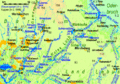 Rotes Luch.gif 1,062 × 743; 135 KB
-
 Rotes Luch.png 1,062 × 743; 133 KB
-
 StobberPipe.jpg 3,072 × 2,048; 2.98 MB


.jpg)
.jpg)
.jpg)


