Category:September 2010 in Norfolk, England
Jump to navigation
Jump to search
Ceremonial counties of England: Bedfordshire · Berkshire · Buckinghamshire · Cambridgeshire · Cheshire · Cornwall · Cumbria · Derbyshire · Devon · Dorset · Durham · East Riding of Yorkshire · East Sussex · Essex · Gloucestershire · Greater London · Greater Manchester · Hampshire · Herefordshire · Hertfordshire · Isle of Wight · Kent · Lancashire · Leicestershire · Lincolnshire · Merseyside · Norfolk · North Yorkshire · Northumberland · Nottinghamshire · Oxfordshire · Shropshire · Somerset · Staffordshire · Suffolk · Surrey · Tyne and Wear · Warwickshire · West Midlands · West Sussex · West Yorkshire · Wiltshire · Worcestershire
City-counties: Bristol ·
Former historic counties:
Other former counties:
City-counties: Bristol ·
Former historic counties:
Other former counties:
Deutsch: Bilder, die im September 2010 in Norfolk, England aufgenommen worden sind. Bitte beachten Sie, dass dies weder das Datum des Uploads noch das Datum des Scannens eines Fotos ist.
English: Images/pictures taken in Norfolk, England during September 2010. Note this is not the date of the upload, nor the date a photo was scanned.
Español: Fotografías o imágenes tomadas en Norfolk, England durante septiembre 2010. No es la fecha de subida ni escaneo, sino la fecha en que las fotografías o imágenes se crearon.
Esperanto: Bildoj faritaj en Norfolk, England en septembro 2010. Tio ne estas la dato, kiam la bildoj estis alŝutitaj aŭ skanitaj.
Français : Photographies ou images prises en Norfolk, England durant septembre 2010. Ce n'est pas la date du téléchargement ou du scan.
Galego: Fotografías ou imaxes tomadas en Norfolk, England durante setembro 2010. Non é a data de subida nin escaneamento, senón a data na que se crearon as fotografías ou imaxes.
Italiano: Fotografie o immagini scattate a Norfolk, England nel settembre 2010. Nota bene: la data non si riferisce né a quella di upload né a quella in cui la foto è stata digitalizzata.
Norsk bokmål: Bilder tatt i Norfolk, England i løpet av september 2010. Merk at dette ikke er datoen for opplasting, eller når et bilde har blitt skannet.
Norsk nynorsk: Bilete teke i Norfolk, England i løpet av september 2010. Merk at dette ikkje er datoen for opplasting, eller når eit bilete har vorte skanna.
Русский: Изображения, сделанные в Norfolk, England в течение сентябрь 2010 (не дата загрузки изображения).
Українська: Зображення, зроблені в Norfolk, England протягом вересень 2010. Зауважте, що це не дата завантаження чи дата сканування фотографії.
| September 2009 | ← | September 2010 | → | September 2011 | |||||||
| Jan | Feb | Mar | Apr | May | Jun | Jul | Aug | Sep | Oct | Nov | Dec |
| 63 | 102 | 250 | 118 | 139 | 160 | 204 | 125 | 63 | 136 | 5 | 44 |
|---|---|---|---|---|---|---|---|---|---|---|---|
Subcategories
This category has the following 2 subcategories, out of 2 total.
Media in category "September 2010 in Norfolk, England"
The following 61 files are in this category, out of 61 total.
-
 97301 at Dereham (1).jpg 2,404 × 2,157; 856 KB
-
 97301 at Dereham.jpg 3,305 × 2,594; 1.09 MB
-
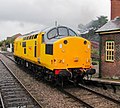
 97301 and 37906 at Dereham.jpg 3,108 × 1,666; 2.26 MB
-
 A swing, beneath the ash tree - geograph.org.uk - 2089923.jpg 640 × 480; 101 KB
-
 A140 in Long Stratton looking North East.jpg 1,280 × 960; 203 KB
-
 Bacton Gas Terminal - geograph.org.uk - 2078818.jpg 800 × 531; 91 KB
-
 Bacton Gas Terminal - geograph.org.uk - 2078821.jpg 800 × 508; 71 KB
-
 Bacton Gas Terminal - geograph.org.uk - 2078823.jpg 800 × 531; 76 KB
-
 Bin day in Quebec Road, Norwich - geograph.org.uk - 2091143.jpg 640 × 480; 120 KB
-
 Black 5 44767 - George Stevenson at Holt.jpg 1,024 × 685; 497 KB
-
 Boat heading downstream on the River Yare - geograph.org.uk - 2246171.jpg 1,024 × 768; 624 KB
-
 Britannia Barracks, Norwich (detail) - geograph.org.uk - 2089636.jpg 480 × 640; 94 KB
-
 Britannia Barracks, Norwich (detail) - geograph.org.uk - 2089639.jpg 480 × 640; 125 KB
-
-
 Britannia Barracks, Norwich - geograph.org.uk - 2089624.jpg 640 × 480; 120 KB
-
 Britannia Barracks, Norwich - geograph.org.uk - 2089628.jpg 640 × 480; 122 KB
-
 Britannia Barracks, Norwich - geograph.org.uk - 2089630.jpg 640 × 517; 147 KB
-
 Britannia Barracks, Norwich - geograph.org.uk - 2089664.jpg 640 × 480; 116 KB
-
 Britannia Barracks, Norwich - geograph.org.uk - 2090078.jpg 640 × 480; 52 KB
-
 Butchers Shop West Runton 16 09 2010.JPG 3,000 × 4,000; 2.09 MB
-
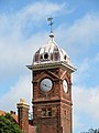
 Town Hall - geograph.org.uk - 2092857.jpg 1,280 × 960; 210 KB
-
 Footpath Across The Fields - geograph.org.uk - 2078816.jpg 800 × 531; 99 KB
-
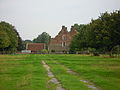 Gateley Hall 06 09 2010.JPG 4,000 × 3,000; 2.54 MB
-
 Holt Lowes.jpg 2,272 × 1,704; 873 KB
-
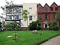
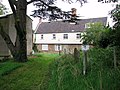 House north of St Mary's church, Earlham - geograph.org.uk - 2079238.jpg 640 × 480; 136 KB
-
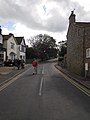
 Houses on Cow Hill, Norwich - geograph.org.uk - 2063909.jpg 640 × 480; 137 KB
-
 Houses on Cow Hill, Norwich - geograph.org.uk - 2063915.jpg 480 × 640; 122 KB
-
 Indian Bean Tree (detail) - geograph.org.uk - 2061516.jpg 640 × 480; 66 KB
-
 Indian Bean Tree at St Peters, Hungate, Norwich - geograph.org.uk - 2061504.jpg 1,024 × 768; 254 KB
-
 Kett's Heights - boundary wall - geograph.org.uk - 2090333.jpg 480 × 640; 211 KB
-

-
 Kett's Heights - former drinking pond - geograph.org.uk - 2090195.jpg 480 × 640; 203 KB
-
 Kett's Heights - gas pipeline - geograph.org.uk - 2090220.jpg 640 × 480; 224 KB
-

-

-
 Kett's Heights - the site of the orchard - geograph.org.uk - 2090204.jpg 640 × 480; 198 KB
-
 Kett's Heights - to St Michael's chapel - geograph.org.uk - 2090234.jpg 640 × 480; 193 KB
-
 St Marys church in Great Yarmouth Southtown (geograph 2209300).jpg 640 × 506; 132 KB
-
 Modern sculpture - geograph.org.uk - 2085390.jpg 1,280 × 960; 419 KB
-
 Mousehold Heath, Norwich - geograph.org.uk - 2061998.jpg 640 × 480; 194 KB
-
 Narrow path up Kett's Heights - geograph.org.uk - 2090210.jpg 480 × 640; 178 KB
-

-
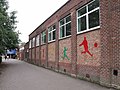 'Old' Gymnasium City of Norwich School - geograph.org.uk - 2075449.jpg 3,648 × 2,736; 1.88 MB
-
 A blustery sky over Bowthorpe - geograph.org.uk - 2062663.jpg 640 × 553; 123 KB
-
 ARC Centre City of Norwich School - geograph.org.uk - 2075444.jpg 3,648 × 2,736; 1.13 MB
-
 Norwich Lower Yard - geograph.org.uk - 2108983.jpg 1,024 × 768; 786 KB
-

-

-

-
 Path on Kett's Heights - geograph.org.uk - 2090224.jpg 640 × 480; 174 KB
-
 Round Britain Cycle Race West Runton 16 09 2010 (1).JPG 3,000 × 4,000; 2.18 MB
-
 Saint Helen parish church, Gateley, 06 09 2010 (1).JPG 4,000 × 3,000; 2.31 MB
-
 Saint Helen parish church, Gateley, 06 09 2010 (2).JPG 4,000 × 3,000; 2.35 MB
-
 St Michael's chapel - Kett's Heights - geograph.org.uk - 2090249.jpg 640 × 480; 182 KB
-
 St Michael's chapel - Kett's Heights - geograph.org.uk - 2090257.jpg 480 × 640; 207 KB
-
 Station Road West Runton 16 09 2010 (6).JPG 3,000 × 4,000; 2.22 MB
-
 Stepped path in Kett's Heights - geograph.org.uk - 2090170.jpg 640 × 480; 193 KB
-
 The gate to Kett's Heights - geograph.org.uk - 2090166.jpg 640 × 486; 166 KB
-
 Thurgarton Church.jpg 2,272 × 1,704; 877 KB
-
 Tour of Britain Cycle Race West Runton 16 09 2010.JPG 3,000 × 4,000; 2.13 MB
-
 View from St James Hill, Norwich - geograph.org.uk - 2089684.jpg 640 × 480; 130 KB
.jpg)


_-_geograph.org.uk_-_2089636.jpg)
_-_geograph.org.uk_-_2089639.jpg)


_-_geograph.org.uk_-_2061516.jpg)


.jpg)


.JPG)
.JPG)
.JPG)


.JPG)


