Category:Soil science
Soil science is the study of soil as a natural resource on the surface of the earth including soil formation, classification and mapping; physical, chemical, biological, and fertility properties of soils; and these properties in relation to the use and management of soils. [1]
It should be distinguished from Soil mechanics: Soil mechanics is a discipline that applies principles of engineering mechanics to predict the mechanical behavior of soils. Foundations, embankments, retaining walls, earthworks and underground openings are all designed in part with theories from soil mechanics. [2] see in Category:Geotechnics

study of soil as a natural resource on the surface of the earth  | |||||
| Upload media | |||||
| Instance of | |||||
|---|---|---|---|---|---|
| Subclass of | |||||
| Part of | |||||
| Different from | |||||
| |||||
Subcategories
This category has the following 42 subcategories, out of 42 total.
#
*
+
- Soil science icons (6 F)
C
- Caliche (38 F)
D
- Darcy's Law (17 F)
- DART (49 F)
E
F
G
- Ground stabilization (13 F)
I
K
- Krotovina (5 F)
L
P
- Paleopedology (6 F)
- Pedons (1 F)
R
S
- Soil stabilization (2 F)
- Soil steam sterilization (10 F)
T
Pages in category "Soil science"
The following 2 pages are in this category, out of 2 total.
Media in category "Soil science"
The following 76 files are in this category, out of 76 total.
-
 "Soil Erosion in Salem".jpg 4,000 × 3,000; 6.2 MB
-
 08Biocrust (6517406791).jpg 4,000 × 3,000; 9.18 MB
-
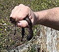
 09Knife (6517347749).jpg 4,000 × 3,000; 6.83 MB
-
 10Transfer (6517359349).jpg 4,000 × 3,000; 6.81 MB
-
 A soil scientist examines soil health. (24816169900).jpg 4,256 × 2,832; 2.6 MB
-
 After Drainage Damaged Corrected (21398457034).jpg 3,648 × 5,472; 13.53 MB
-
 Amostragem-de-solo-com-estrutura-preservada.jpg 1,024 × 768; 271 KB
-
 Análise física do solo.jpg 3,328 × 1,872; 978 KB
-
 Apb thick o horizon.jpg 1,950 × 1,600; 2.22 MB
-
 Argillans.JPG 369 × 544; 47 KB
-
 BissauPolders.jpg 553 × 359; 62 KB
-
 Bodenkriechen.jpg 4,000 × 3,000; 4.82 MB
-
 Bodensäule vergrößert Senckenberg Museum Görlitz Mike Krüger 180930.jpg 3,648 × 5,472; 7.11 MB
-

-

-
 Cerosidade, película fina de argila revestindo um agregado.jpg 587 × 391; 110 KB
-
 Coleta indeformada de solo.jpg 717 × 1,274; 281 KB
-
 Colonia microbiologica de un Suelo del Alto Valle de Río Negro.jpg 3,060 × 4,080; 2.68 MB
-
 Destroyed Part of Field - DPLA - dac0601438d504770d836ab7e8964c7a.jpg 1,678 × 1,020; 226 KB
-

-
 Erdschichtenmodell Stratorama - Grabungsschnitt (306).jpg 2,736 × 3,648; 2.24 MB
-
 Extractos de Suelo Vivo.jpg 900 × 1,600; 113 KB
-
 FAO - 2015 anno dei suoli P1080518.jpg 3,456 × 4,608; 6.1 MB
-
 Frost heaving.jpg 4,288 × 3,216; 3.05 MB
-
 Granulos.jpg 1,392 × 1,040; 93 KB
-
 Grondreiniging dwr.jpg 600 × 402; 59 KB
-
 Hetény078.JPG 3,648 × 2,736; 2.62 MB
-
 Hgn-Agregat sol d'activite-LPR.jpg 1,155 × 596; 1.02 MB
-
 Hgn-bloc micromorpho.jpg 960 × 1,280; 1.11 MB
-
 Hgn-Charbon-LNA.jpg 850 × 758; 852 KB
-
 High groundwater damage on the Veszprém Plateau 01.JPG 3,120 × 2,080; 3.47 MB
-
 Humusgehalt.jpg 2,508 × 1,551; 2.47 MB
-
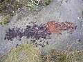
 IJzersporen in zandbodem.jpg 1,037 × 691; 171 KB
-
 IMG-20230526-WA0001.jpg 1,579 × 775; 151 KB
-
 IMG-20230526-WA0002.jpg 1,600 × 900; 262 KB
-
 IMG-20230526-WA0003.jpg 1,600 × 900; 218 KB
-
 IMG-20230526-WA0004.jpg 1,600 × 900; 261 KB
-
 Ivan Alekseev.jpg 2,560 × 1,707; 694 KB
-
 Klappersteen1.jpg 568 × 496; 24 KB
-
 Klappersteen2.jpg 715 × 418; 27 KB
-
 Kohlensaurer Kalk.jpg 2,550 × 1,881; 4.28 MB
-
 Komárom517.JPG 3,648 × 2,736; 2.62 MB
-
 Leemwoestijnoppervlak.PNG 652 × 534; 618 KB
-
 Nc-red-clay-soil-1.jpg 2,560 × 1,920; 531 KB
-
 Nc-red-clay-soil-2.jpg 2,560 × 1,920; 562 KB
-
 Odkrywka1.JPG 3,264 × 2,448; 2.51 MB
-
 Oerijzer TN.JPG 600 × 486; 76 KB
-
 Olzreute-Enzisholz 2016-07-24 2.jpg 2,000 × 3,000; 7.57 MB
-
 Pesticide toxicology lab.jpg 2,560 × 1,536; 1.67 MB
-
 Plaike.jpg 2,288 × 1,712; 458 KB
-
 Producto final.JPG 5,152 × 3,864; 7.87 MB
-
 Pédologie micro cheminées de fées Guyane MASSEMIN 2011.jpg 450 × 350; 305 KB
-
 RamRayDomRepSoil.png 972 × 968; 1.88 MB
-
 Runoff of soil & fertilizer.jpg 2,100 × 1,500; 1.13 MB
-
 Sandy soil surface.jpg 800 × 460; 135 KB
-
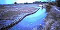 SeawaterInlet.jpg 553 × 275; 51 KB
-
 Soil experiment (7000920647).jpg 1,003 × 1,000; 66 KB
-
 Soil horizons.JPG 640 × 480; 94 KB
-
 Soil material containing Sand, silt, clay.jpg 3,504 × 2,336; 4.61 MB
-
 Soils - General - DPLA - 51c4b0e6de441b38d76b140695e1da9a.jpg 2,733 × 3,930; 852 KB
-
 Spun-how-it-works-horizontal-stack.png 888 × 284; 285 KB
-
 Stabilized soil mixing plant.jpg 400 × 300; 32 KB
-

-
 Stream without conservation buffers.jpg 2,100 × 1,500; 1.42 MB
-
 Tanah terbiar di Bandar Baru Bangi.jpg 2,592 × 1,944; 1.54 MB
-
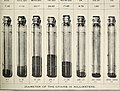 Texture of some important soil formations (1896) (14594863737).jpg 2,208 × 1,672; 1.19 MB
-
 Torv h1.JPG 1,031 × 1,672; 462 KB
-
 Torv H8.JPG 1,644 × 1,443; 702 KB
-
 Urban soil experiment (6931111952).jpg 1,603 × 1,603; 330 KB
-
 Urgesteinsmehl.jpg 2,886 × 1,950; 3.25 MB
-
 Water coarse beads.JPG 338 × 304; 24 KB
-
 Weilbach Kiesgruben fg01.jpg 1,200 × 798; 654 KB
-
 В окрестностях Фрумушики.jpg 5,472 × 3,132; 21.45 MB
-
 Магнітна мульча з ПЕТ пляшки.jpg 3,264 × 2,176; 1.83 MB
-
 Создание почвенного разреза.jpg 4,000 × 3,000; 3.2 MB
-
 קרום קרקע ביולוגי.jpg 2,265 × 1,505; 1.25 MB

.jpg)
.jpg)
.jpg)
.jpg)


.jpg)


.jpg)


_(14594863737).jpg)


.jpg)


.jpg)
_(14595943777).jpg)