Category:St. Maria Neudorf (St. Gallen)
Jump to navigation
Jump to search
| Object location | | View all coordinates using: OpenStreetMap |
|---|
 | |||||
| Upload media | |||||
| Instance of | |||||
|---|---|---|---|---|---|
| Part of | |||||
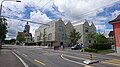
| Location | St. Gallen, St. Gallen Constituency, canton St. Gallen, Switzerland | ||||
| Street address |
| ||||
| Heritage designation | |||||
 | |||||
Media in category "St. Maria Neudorf (St. Gallen)"
The following 11 files are in this category, out of 11 total.
-
 CA KGS 10154 SG MariaNeudorf.jpg 4,738 × 4,680; 2.29 MB
-
 ETH-BIB-St. Gallen, Bahnhof St. Fiden-Inlandflüge-LBS MH03-1713.tif 6,152 × 4,288; 75.65 MB
-
 Kirche St. Maria.jpg 1,364 × 966; 1,012 KB
-
 Marienkirche im Neudorf - panoramio.jpg 2,592 × 1,944; 2.21 MB
-
 Marienkirche Neudorf - panoramio.jpg 2,048 × 1,536; 503 KB
-
 Naturmuseum St. Gallen und Kirche St. Maria Neudorf.jpg 3,840 × 2,160; 3.14 MB
-
 NaturmuseumSG Kirche02.jpg 3,630 × 2,595; 3.21 MB
-
 Schweiz Unterwegs 131DSC 0082 (48429925406).jpg 1,218 × 1,311; 331 KB
-
 StadtASG B 2595.tif 1,652 × 1,055; 5.01 MB
-
 StadtASG B 453.jpg 1,620 × 1,076; 2.13 MB
-
 StadtASG B 456.jpg 1,615 × 1,034; 2.58 MB


.jpg)

