Category:St Mary's Road bridge, Garston
Jump to navigation
Jump to search
| Object location | | View all coordinates using: OpenStreetMap |
|---|
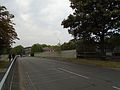
This bridge carries St Mary's Road, Garston, Liverpool over the Northern Line (southern section) of Merseyrail. Its Network Rail code is HXS1/41 and it is 4m 1702yd from Liverpool Central station. Since the A561 is a dual carriageway at this point, the bridge is actually in two sections, east and west.
Media in category "St Mary's Road bridge, Garston"
The following 7 files are in this category, out of 7 total.
-
 St Mary's Road bridge, east 1.jpg 5,152 × 3,864; 6.92 MB
-
 St Mary's Road bridge, east 2.jpg 5,152 × 3,864; 6.92 MB
-
 St Mary's Road bridge, east 3.jpg 5,152 × 3,864; 6.62 MB
-
 St Mary's Road bridge, east 4.jpg 5,152 × 3,864; 7.68 MB
-
 St Mary's Road bridge, plaque.jpg 5,152 × 3,864; 7.35 MB
-
 St Mary's Road bridge, west 1.jpg 5,152 × 3,864; 7.33 MB
-
 St Mary's Road bridge, west 2.jpg 5,152 × 3,864; 7.18 MB


