Category:Surrender Hill
Jump to navigation
Jump to search
Afrikaans: Surrender Hill is langs die R711 by Slaapkrans in die Brandwaterkom van die oos-Vrystaat geleë. Hier het 4,314 Boere onder generaal Prinsloo aan Britse magte oorgegee op 30 Julie 1900. De Wet het egter geslaag om van die omsingeling te ontsnap.
English: Surrender Hill is situated beside the R711 at Slaapkrans in the eastern Free State, South Africa. It marks the spot where a quantity of Boer ammunition was destroyed after 4,314 Boer combatants under general Prinsloo surrendered to British forces in the Brandwater basin on 30 July 1900.
| Object location | | View all coordinates using: OpenStreetMap |
|---|
hill in eastern Free State, South Africa  | |||||
| Upload media | |||||
| Instance of | |||||
|---|---|---|---|---|---|
| Location |
| ||||
 | |||||
Media in category "Surrender Hill"
The following 8 files are in this category, out of 8 total.
-

-
 Boere-krygsgevangenes op Ceylon, hoofsaaklik van Brandwaterkom onder genl Prinsloo.jpg 1,855 × 2,128; 1.5 MB
-

-
 Resa del bacino del Brandewater.jpg 600 × 412; 82 KB
-
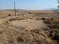 Sandkol by Surrender Hill, R711, Slaapkrans, oos-Vrystaat.jpg 4,000 × 3,000; 3.7 MB
-
 Surrender Hill 01, monument.jpg 2,048 × 1,536; 831 KB
-
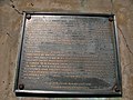 Surrender Hill 02, plaque on monument.jpg 2,048 × 1,536; 739 KB
-
 Surrender Hill, R711, Slaapkrans, oos-Vrystaat.jpg 4,000 × 3,000; 4.04 MB


.jpg)


