Category:Säntis
Jump to navigation
Jump to search
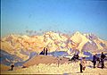
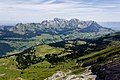
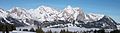
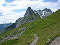
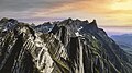
English: Säntis (2,502 m) is a mountain in the Alpstein sub-range of the Appenzell Alps in Switzerland.
Esperanto: Säntis estas kun 2502 m s.n. la plej alta pinto de la Alpsteinmasivo en orienta Svislando.
peak in northeastern Switzerland  | |||||
| Upload media | |||||
| Instance of | |||||
|---|---|---|---|---|---|
| Made from material | |||||
| Location | |||||
| Significant event |
| ||||
| Mountain range | |||||
| Topographic prominence |
| ||||
| Topographic isolation |
| ||||
| Elevation above sea level |
| ||||
 | |||||
Subcategories
This category has the following 12 subcategories, out of 12 total.
*
A
B
H
L
R
S
- Sendeanlagen Säntis (20 F)
- Säntis in art (13 F)
T
- Tierwis (13 F)
V
- Views from Säntis (33 F)
W
- Wetterwarte Säntis (12 F)
Media in category "Säntis"
The following 128 files are in this category, out of 128 total.
-
 1115 Säntis.jpg 14,000 × 9,600; 117.64 MB
-
 1865-Bötzel-W.jpg 4,050 × 2,700; 3.28 MB
-
 Segelflug Trogen7.jpg 3,404 × 2,300; 745 KB
-
 1974 Chaserrugg 06.JPG 2,149 × 1,484; 682 KB
-
 1976 Säntis 01.JPG 2,272 × 1,704; 756 KB
-
 1976 Säntis 08.JPG 1,540 × 2,091; 678 KB
-
 2009-04-16 Säntis 02.jpg 8,568 × 1,445; 3.07 MB
-
 20090801-23 Säntis.JPG 4,000 × 3,000; 6.65 MB
-
 2011-08-04 15-10-33 Switzerland Unterwasser.jpg 4,288 × 2,848; 3.61 MB
-
 2011-08-04 15-18-28 Switzerland Unterwasser.jpg 4,157 × 2,761; 2.86 MB
-
 2011-08-04 15-20-39 Switzerland Unterwasser.jpg 4,288 × 2,848; 7.3 MB
-
 2015-01-01 14-19-24 927.0 Switzerland Kanton St. Gallen Unterwasser Unterwasser.jpg 4,116 × 2,734; 6.12 MB
-
 2015-01-01 15-02-16 1084.2 Switzerland Kanton St. Gallen Unterwasser Lisighaus.jpg 2,848 × 4,288; 7.55 MB
-
 2015-01-01 15-07-41 1083.0 Switzerland Kanton St. Gallen Unterwasser Lisighaus.jpg 4,007 × 2,661; 6.71 MB
-
 2015-01-01 15-17-33 1058.0 Switzerland Kanton St. Gallen Unterwasser Unterwasser.jpg 4,288 × 2,848; 6.57 MB
-
 2015-01-01 15-21-24 1046.0 Switzerland Kanton St. Gallen Unterwasser Unterwasser.jpg 4,281 × 1,640; 3.45 MB
-
 2015-01-01 15-21-38 1043.6 Switzerland Kanton St. Gallen Unterwasser Unterwasser.jpg 3,843 × 2,552; 4.91 MB
-
 2015-01-01 15-36-06 976.0 Switzerland Kanton St. Gallen Unterwasser Unterwasser.jpg 4,242 × 2,817; 6.11 MB
-
 20180929-20180929-DJI 0377-HDR-Pano.jpg 1,920 × 828; 1.63 MB
-
 360° Staubern Rheintal.jpg 8,983 × 1,655; 3.9 MB
-
 500px photo (44614126).jpeg 2,048 × 1,366; 463 KB
-
 60er Toggenburg 07.jpg 2,272 × 1,584; 902 KB
-
 Alpstein from Frümsel.jpg 2,048 × 1,365; 1.52 MB
-
 Alpstein im Winter.jpg 6,016 × 4,000; 9.73 MB
-
 Alpstein there and back.jpg 7,806 × 5,244; 6.47 MB
-
 Alpstein winter.jpg 3,985 × 1,101; 2.53 MB
-
 Alpstein.jpg 3,200 × 2,592; 1.06 MB
-
 Alpstein13.jpg 5,015 × 1,452; 3.37 MB
-
 Baggersee Brederis.jpg 1,206 × 680; 117 KB
-
 Berggasthof rotsteinpass.jpg 896 × 538; 108 KB
-
 Blick vom Säntis ins Alpsteinmassiv.jpg 6,016 × 4,000; 10.99 MB
-
 Blick von Kellen auf Säntis.jpg 3,264 × 2,448; 3.29 MB
-
 Blue Rich Mountain (2116676242).jpg 2,410 × 3,615; 3.74 MB
-
 Charte von Schwaben Tafel 59 Sentis.jpg 2,150 × 2,622; 4.97 MB
-
 Chräzerenwald.jpg 4,000 × 2,248; 3.69 MB
-
 Ehem. Back- und Waschhaus Kirchgasse 13 in Zihlschlacht.jpg 2,880 × 3,600; 6.73 MB
-
 ETH-BIB-Gäbris ob Gais-AR-Dia 002-010.tif 3,300 × 2,509; 23.78 MB
-

-
 ETH-BIB-Säntisprofile, Nord-Ost-Dia 247-02301.tif 3,687 × 2,776; 9.86 MB
-
 ETH-BIB-Säntisprofile, Süd-West-Dia 247-02302.tif 3,550 × 2,802; 9.58 MB
-
 Färetmoos.jpg 2,248 × 4,000; 3.86 MB
-
 Gafadurahuette-Saentisstock-06.JPG 4,592 × 2,576; 4.38 MB
-
 Gafadurahuette-Toggenburg-Saentisstock-04.JPG 4,592 × 2,576; 4.66 MB
-
 Gräppelen Säntis.jpg 1,077 × 1,498; 298 KB
-
 Herrenwald 1961.jpg 2,234 × 1,570; 914 KB
-
 Imposanter Säntis.jpg 3,456 × 2,304; 6.4 MB
-
 IR 75 bei Altishausen TG.jpg 4,000 × 2,500; 6.04 MB
-
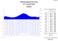 Klimadiagramm-metrisch-deutsch-Säntis(Alpen).Schweiz.png 1,024 × 713; 2.09 MB
-
 Kronberg Säntis.jpeg 4,032 × 3,024; 2.05 MB
-
 Kronberg-Säntis, Switzerland1.jpg 6,000 × 4,000; 14.68 MB
-
 Kronberg-Säntis, Switzerland10.jpg 6,000 × 4,000; 17.16 MB
-
 Kronberg-Säntis, Switzerland11.jpg 6,000 × 4,000; 16.37 MB
-
 Kronberg-Säntis, Switzerland12.jpg 6,000 × 4,000; 18.03 MB
-
 Kronberg-Säntis, Switzerland13.jpg 6,000 × 4,000; 13.12 MB
-
 Kronberg-Säntis, Switzerland14.jpg 6,000 × 4,000; 14.88 MB
-
 Kronberg-Säntis, Switzerland15.jpg 6,000 × 4,000; 14.31 MB
-
 Kronberg-Säntis, Switzerland16.jpg 6,000 × 4,000; 14.73 MB
-
 Kronberg-Säntis, Switzerland17.jpg 6,000 × 4,000; 13.59 MB
-
 Kronberg-Säntis, Switzerland18.jpg 6,000 × 4,000; 16.19 MB
-
 Kronberg-Säntis, Switzerland19.jpg 4,000 × 6,000; 28.08 MB
-
 Kronberg-Säntis, Switzerland2.jpg 6,000 × 4,000; 11.27 MB
-
 Kronberg-Säntis, Switzerland20.jpg 6,000 × 4,000; 27.67 MB
-
 Kronberg-Säntis, Switzerland3.jpg 6,000 × 4,000; 19.93 MB
-
 Kronberg-Säntis, Switzerland4.jpg 6,000 × 4,000; 12.39 MB
-
 Kronberg-Säntis, Switzerland5.jpg 6,000 × 4,000; 13.15 MB
-
 Kronberg-Säntis, Switzerland6.jpg 6,000 × 4,000; 12.58 MB
-
 Kronberg-Säntis, Switzerland7.jpg 6,000 × 4,000; 11.85 MB
-
 Kronberg-Säntis, Switzerland8.jpg 6,000 × 4,000; 14.28 MB
-
 Kronberg-Säntis, Switzerland9.jpg 6,000 × 4,000; 15.23 MB
-
 Lake of Zürich with Säntis and Speer.jpg 6,000 × 3,375; 15.51 MB
-
 Lisengrat05.jpg 1,500 × 2,000; 1.52 MB
-
 LisengratPanorama02.jpg 6,227 × 1,894; 6.03 MB
-
 Luftseilbahn zum Säntis.jpg 3,200 × 2,133; 3.64 MB
-
 Lysengratweg und Säntisblick.jpg 3,456 × 2,304; 4.09 MB
-
 Morning hiking.jpg 4,000 × 3,000; 4.29 MB
-
 Neckertal und Säntis.jpg 3,264 × 2,448; 3.34 MB
-
 NW-Seite des Säntis (Schwägalp, 2013).jpg 3,200 × 4,800; 11.91 MB
-
 Oberstaufen - Salmaser Höhe - Weißachtal Ri SW, Säntis, Schweiz (sw).jpg 2,272 × 1,704; 673 KB
-
 Pfarrkirche, Schaan (1Y7A2265).jpg 5,704 × 3,803; 13.48 MB
-
 Picswiss AI-04-06.jpg 500 × 333; 54 KB
-
 Picswiss AI-06-07.jpg 500 × 333; 42 KB
-
 Rebstein - riethof mit säntis - panoramio.jpg 2,485 × 1,653; 573 KB
-
 RGA 211790.jpg 8,192 × 5,715; 14.78 MB
-
 Rotsteinpass 5355.jpg 1,600 × 1,200; 592 KB
-
 Rundweg Gamserrugg Tafel 10 und Säntis.jpg 4,896 × 3,264; 7.57 MB
-
 Runter von Saentis - panoramio.jpg 2,048 × 1,536; 789 KB
-
 S-Bahn SG Logo Ostwind.jpg 1,029 × 862; 183 KB
-
 Saentis 5357.jpg 1,600 × 1,200; 650 KB
-
 SaentisAufstiegWagenluecke.jpg 4,000 × 3,000; 5.54 MB
-
 SaentisGipfel1.jpg 4,000 × 3,000; 5.28 MB
-
 Saentismitwarte.jpg 1,280 × 833; 381 KB
-
 Santis 2018.jpg 4,032 × 3,024; 3.41 MB
-
 Santis Restaurant (116753613).jpeg 2,048 × 1,536; 1.25 MB
-
 Santis.jpg 933 × 622; 129 KB
-
 Schäfler Ridge - Alpstein.jpg 3,840 × 2,160; 4.94 MB
-
 Schönengrund (AR) (4).jpg 1,500 × 2,000; 2.13 MB
-
 Seealpsee Käserei 2.jpg 5,408 × 3,605; 15.32 MB
-
 Spalierobst bei Kehlhof, Sulgen, Thurtal & Säntis.jpg 4,800 × 3,600; 11.87 MB
-
 Summit , Säntis, Swiss ©Abdullah Kiyga - panoramio.jpg 4,288 × 2,848; 3.76 MB
-
 Sunrise on Säntis.jpg 1,440 × 1,080; 706 KB
-
 Switzerland, Säntis Mnt - panoramio - Michael Karavanov.jpg 5,770 × 1,950; 3.27 MB
-
 Switzerland, Säntis Mnt - panoramio.jpg 5,280 × 1,992; 2.43 MB
-
 Säntis (Bergstation) im Winter.jpg 4,200 × 2,800; 8.43 MB
-
 Säntis - 29.07.01 0062.jpg 768 × 1,024; 194 KB
-
 Säntis - 29.07.01 0069.jpg 1,024 × 768; 295 KB
-
 Säntis - 29.07.01 0090.jpg 768 × 1,024; 192 KB
-
 Säntis - 29.07.01 0091.JPG 1,024 × 768; 136 KB
-
 Säntis - 29.07.01 0092.JPG 1,024 × 768; 93 KB
-
 Säntis - panoramio (3).jpg 2,560 × 1,920; 1.37 MB
-
 Säntis 3.jpg 4,608 × 2,128; 2.25 MB
-
 Säntis 4.jpg 2,048 × 1,536; 3.07 MB
-
 Säntis Bergstation - aus 60 km Entfernung fotografiert.jpg 2,994 × 1,430; 849 KB
-
 Säntis in winter.jpg 6,000 × 3,375; 13.81 MB
-
 Säntis mountain switzerland.jpg 8,208 × 1,320; 1.02 MB
-
 Säntis panosphere 20210812.jpg 12,700 × 6,350; 69.58 MB
-
 Säntis Sendeanlage.jpg 1,120 × 752; 668 KB
-
 Säntis und Schafberg.JPG 5,184 × 3,456; 3.59 MB
-
 Säntis von Laui aus.jpg 3,072 × 2,304; 2.9 MB
-
 Säntis west.jpg 1,007 × 675; 127 KB
-
 Säntis, Schwende District, Switzerland (Unsplash xjXz8GKXcTI).jpg 2,000 × 1,333; 1.52 MB
-
 Säntis-Swiss.JPG 1,536 × 2,048; 366 KB
-
 Säntis.jpg 4,608 × 2,592; 2.6 MB
-
 SäntisToRotsteinpass.jpg 3,468 × 4,624; 179 KB
-
 Tunnel-505977.jpg 3,456 × 4,608; 3.5 MB
-
 Visitor On Saentis Mountain (204156179).jpeg 2,048 × 981; 612 KB
-
 Wegweiser am Lysengrat.jpg 3,456 × 2,304; 4.1 MB
-
 Weißensberg, LI - Wildberg v NO, Säntis 01 (cropped).jpg 3,264 × 466; 578 KB
-


.jpeg)


.jpg)


.Schweiz.png)


.jpg)
.jpg)
.jpg)


.jpeg)


_(4).jpg)


_im_Winter.jpg)


.jpg)


.jpg)


.jpeg)


.jpg)
Categories:
- Alpstein
- Ostschweiz
- Federal Inventory of Landscapes and Natural Monuments of National Importance
- Snowy landscapes in the canton of St. Gallen
- Hundwil
- Schwende
- Wildhaus-Alt Sankt Johann
- Mountains in the canton of Appenzell Ausserrhoden
- Mountains in the canton of Appenzell Innerrhoden
- Mountains in the canton of St. Gallen
- Mountains of Appenzell Alps
- Mountains of Switzerland by name
- 2500s mountains of Switzerland
- Highest points of Swiss cantons
- Cantonal tripoints of Switzerland