Category:Tarnogaj estate for gas company workers
Jump to navigation
Jump to search
| Object location | | View all coordinates using: OpenStreetMap |
|---|
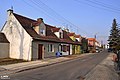
Polski: Wrocław - osiedle dla pracowników gazowni zaprojektowane w 1919. Zabudowa ul. Kamienieckiej, Ząbkowickiej i Złotostockiej pomiędzy ul. Gazową i Klimasa.
 | |||||
| Upload media | |||||
| Instance of | |||||
|---|---|---|---|---|---|
| Location | Wrocław, Lower Silesian Voivodeship, Poland | ||||
| Heritage designation | |||||
 | |||||
Media in category "Tarnogaj estate for gas company workers"
The following 7 files are in this category, out of 7 total.
-
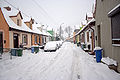 Kamieniecka Tarnogaj zima.jpg 3,474 × 2,314; 1.25 MB
-
 Wrocław - fotopolska.eu (113525).jpg 1,250 × 822; 176 KB
-
 Wrocław - fotopolska.eu (113526).jpg 1,250 × 830; 182 KB
-
 Wrocław - fotopolska.eu (113529).jpg 1,250 × 823; 188 KB
-
 Wrocław - fotopolska.eu (287279).jpg 1,250 × 833; 180 KB
-
 Wrocław, Złotostocka 16-22 - fotopolska.eu (113534).jpg 1,250 × 827; 178 KB
-
 Wrocław, Złotostocka 6-12 - fotopolska.eu (113673).jpg 1,250 × 823; 183 KB
.jpg)
.jpg)
.jpg)
.jpg)
.jpg)
.jpg)