Category:United Kingdom photographs taken on 2009-05-04
Jump to navigation
Jump to search
Countries of Europe: Austria · Belgium · Bosnia and Herzegovina · Bulgaria · Croatia · Czech Republic · Denmark · Estonia · Finland · France‡ · Germany · Greece · Hungary · Republic of Ireland · Italy · Latvia · Montenegro · Netherlands‡ · Poland · Portugal‡ · Romania · Russia‡ · Serbia · Slovakia · Spain‡ · Sweden · Switzerland · Turkey‡ · Ukraine · United Kingdom
‡: partly located in Europe
‡: partly located in Europe
| ← | 4 May 2009 | → | ||
| ← | May 2009 | → | ||

United Kingdom photographs taken on 4 May 2009.
Image files should be categorized here automatically using {{taken on}} template. Direct categorisation is also possible, if automatic is impossible.
Media in category "United Kingdom photographs taken on 2009-05-04"
The following 200 files are in this category, out of 838 total.
(previous page) (next page)-

-
 2009 at Defiance platform.jpg 1,024 × 768; 429 KB
-
 2009 at Saltash station - 4 May celebrations.jpg 800 × 600; 243 KB
-
 2009 at Saltash station - new plaque unveiled.jpg 800 × 600; 180 KB
-
 2009 at Truro station - platform 3.jpg 1,366 × 1,024; 345 KB
-
 2009 at Truro station - signal box.jpg 1,366 × 1,024; 385 KB
-
 35 and 37-39 West Street - geograph.org.uk - 1305948.jpg 640 × 480; 135 KB
-
 45 Church Street - geograph.org.uk - 1306739.jpg 640 × 480; 123 KB
-
 48 Church Street - geograph.org.uk - 1306749.jpg 640 × 480; 56 KB
-
 7 and 9 Castlefield Road - geograph.org.uk - 1306795.jpg 640 × 480; 75 KB
-
 A clamour of rooks on Portsdown Hill - geograph.org.uk - 1286083.jpg 640 × 480; 93 KB
-
 A clapper bridge across the Afon Arthog - geograph.org.uk - 1310586.jpg 640 × 480; 102 KB
-
 A country house in Up Nately - geograph.org.uk - 1286961.jpg 640 × 471; 53 KB
-

-

-

-
 A5, Woodlough Road - geograph.org.uk - 1289551.jpg 640 × 479; 54 KB
-
 A614 Tanglewood roundabout - geograph.org.uk - 1287197.jpg 640 × 480; 42 KB
-
 A645 Camblesforth - geograph.org.uk - 1287437.jpg 640 × 480; 49 KB
-
 Abandoned farm at Boswarthen - geograph.org.uk - 1297159.jpg 640 × 427; 76 KB
-
 Aberdeen Place - geograph.org.uk - 1291530.jpg 640 × 480; 93 KB
-
 Above Clashfern - geograph.org.uk - 1297674.jpg 640 × 480; 66 KB
-
 Above Clashfern - geograph.org.uk - 1297682.jpg 640 × 480; 68 KB
-

-
-
-
 Above Lulworth - geograph.org.uk - 1355759.jpg 640 × 455; 112 KB
-
 Above Southern shore of Loch Ness - geograph.org.uk - 1286227.jpg 640 × 480; 65 KB
-
 Access road in The Dean Estate - geograph.org.uk - 1286537.jpg 640 × 427; 213 KB
-
 Access road on The Dean Estate - geograph.org.uk - 1286568.jpg 640 × 427; 146 KB
-
 Access road to The Dean Estate - geograph.org.uk - 1286476.jpg 640 × 427; 183 KB
-

-
 All Jumps - geograph.org.uk - 1292228.jpg 640 × 480; 133 KB
-

-
 Allt a Ghleannain - geograph.org.uk - 1297757.jpg 640 × 480; 106 KB
-
 Allt a Ghleannain - geograph.org.uk - 1297761.jpg 640 × 480; 103 KB
-
 Allt a Ghleannain - geograph.org.uk - 1297763.jpg 640 × 480; 106 KB
-
 Almost ready to go^ - geograph.org.uk - 1285901.jpg 640 × 480; 120 KB
-
 Along the hill to the Fforest - geograph.org.uk - 1297148.jpg 640 × 426; 48 KB
-

-

-
 Another gully - geograph.org.uk - 1297155.jpg 640 × 426; 79 KB
-
 Archway at Wainstalls House Lodge - geograph.org.uk - 1293533.jpg 480 × 640; 91 KB
-

-

-
 Back Lane - Town Street - geograph.org.uk - 1287192.jpg 527 × 640; 257 KB
-
 Badnabay - geograph.org.uk - 1297768.jpg 640 × 480; 64 KB
-
 Balgay Farm, Inchture - geograph.org.uk - 1294473.jpg 640 × 426; 32 KB
-
 Bancroft House - geograph.org.uk - 1306709.jpg 640 × 480; 91 KB
-
 Bancroft Place - geograph.org.uk - 1306754.jpg 640 × 480; 68 KB
-
 Bare field with distant Rape - geograph.org.uk - 1286337.jpg 640 × 480; 90 KB
-
 Barges on the Regent's Canal - geograph.org.uk - 1291544.jpg 640 × 480; 129 KB
-
 Barmouth Bridge - geograph.org.uk - 1310509.jpg 640 × 480; 91 KB
-
 Dam Road, Barton Upon Humber - geograph.org.uk - 1286824.jpg 640 × 350; 48 KB
-

-
 Beautifully blue - geograph.org.uk - 1287313.jpg 441 × 640; 67 KB
-
 Bernaville Garden Centre - geograph.org.uk - 1285952.jpg 640 × 480; 172 KB
-
 Biddenham - geograph.org.uk - 1292117.jpg 640 × 428; 109 KB
-
 Bike stands, Norwich city centre - geograph.org.uk - 1288262.jpg 640 × 480; 94 KB
-
 Bikers assemble on the seafront - geograph.org.uk - 1297644.jpg 640 × 430; 85 KB
-
 Billiegoat Farm - geograph.org.uk - 1287265.jpg 640 × 480; 61 KB
-
 Birley Spa Boating Lake - geograph.org.uk - 1286662.jpg 640 × 480; 117 KB
-
 Blaegrove Lane - geograph.org.uk - 1286846.jpg 640 × 475; 99 KB
-
 Bluebells in Sweets Wood - geograph.org.uk - 1291038.jpg 640 × 480; 153 KB
-
 Bluebells, Dane valley - geograph.org.uk - 1289565.jpg 640 × 426; 91 KB
-
 Bluebells, Newton Wood - geograph.org.uk - 1290454.jpg 640 × 427; 119 KB
-
 Boakes Rents, All Saint's St - geograph.org.uk - 1298138.jpg 640 × 406; 50 KB
-
 Board in The Old Town Hall - geograph.org.uk - 1306610.jpg 480 × 640; 90 KB
-
-
 Boundary Marker - geograph.org.uk - 1286399.jpg 640 × 480; 158 KB
-
 Bowley Lane over M20 Motorway - geograph.org.uk - 1291074.jpg 640 × 480; 78 KB
-
 Bransby Rise - Springbank Close - geograph.org.uk - 1286308.jpg 640 × 480; 220 KB
-
 Breakwater, Hastings Harbour - geograph.org.uk - 1298199.jpg 640 × 430; 70 KB
-
 Brick Kiln bridge - geograph.org.uk - 1286973.jpg 640 × 480; 141 KB
-
 Brick Kiln Bridge - geograph.org.uk - 1295978.jpg 640 × 480; 124 KB
-

-
 Bridge on the canal - geograph.org.uk - 1294266.jpg 640 × 480; 138 KB
-
 Bridge over the River Aire - geograph.org.uk - 1287205.jpg 640 × 480; 28 KB
-
 Bridge over the River Aire - geograph.org.uk - 1287214.jpg 640 × 480; 55 KB
-
 Bridge over the River Dane - geograph.org.uk - 1289702.jpg 640 × 426; 62 KB
-
 Bridge Terrace, Wainstalls - geograph.org.uk - 1289835.jpg 640 × 480; 69 KB
-
 Bridleway from Elvey Farm - geograph.org.uk - 1292569.jpg 640 × 480; 123 KB
-
 Bridleway leading to Botrea - geograph.org.uk - 1297103.jpg 640 × 427; 129 KB
-
 Bridleway on Prebbles Hill - geograph.org.uk - 1292576.jpg 640 × 480; 119 KB
-
 Bridleway, Verditch Chase - geograph.org.uk - 1285591.jpg 640 × 481; 232 KB
-
-
 Broom explosion - geograph.org.uk - 1290480.jpg 640 × 480; 333 KB
-
 Broughton Gate - geograph.org.uk - 1692253.jpg 640 × 430; 72 KB
-
 Browne's Lodge - geograph.org.uk - 1290322.jpg 640 × 480; 90 KB
-
 Bugle patch, Linton Wood - geograph.org.uk - 1287301.jpg 452 × 640; 196 KB
-
 Buildings adjacent to Regent's Canal - geograph.org.uk - 1291662.jpg 640 × 459; 86 KB
-
 Burn of Brown - geograph.org.uk - 1286848.jpg 640 × 427; 379 KB
-
 Burn of Brown - geograph.org.uk - 1286884.jpg 640 × 427; 353 KB
-
 Burnside, Coldingham - geograph.org.uk - 1286529.jpg 640 × 480; 97 KB
-
 Bus Shelter on A20 Ashford Road - geograph.org.uk - 1292768.jpg 640 × 480; 64 KB
-
 Byway gate on North Downs Way - geograph.org.uk - 1292824.jpg 640 × 480; 135 KB
-
 Byway to Little Pipers Wood - geograph.org.uk - 1292593.jpg 640 × 480; 130 KB
-
 Byway to Timbold Hill - geograph.org.uk - 1291028.jpg 640 × 480; 148 KB
-

-
 Cae Cymric, Canal Road, Newtown. - geograph.org.uk - 1285911.jpg 640 × 480; 117 KB
-
 Cairn on Cairnagour - geograph.org.uk - 1286406.jpg 640 × 480; 103 KB
-
 Camblesforth Roundabout A645 A1041 - geograph.org.uk - 1287433.jpg 640 × 480; 37 KB
-
 Candy's Pit Trail (1) - geograph.org.uk - 1286239.jpg 480 × 640; 128 KB
-
 Candy's Pit Trail (2) - geograph.org.uk - 1286251.jpg 640 × 480; 150 KB
-
 Candy's Pit Trail (3) - geograph.org.uk - 1286504.jpg 640 × 480; 131 KB
-
 Candy's Pit Trail (4) - geograph.org.uk - 1286538.jpg 640 × 480; 87 KB
-
 Carlton Railway Bridge - geograph.org.uk - 1287422.jpg 640 × 480; 45 KB
-
 Carn Euny ancient village - geograph.org.uk - 1297227.jpg 640 × 427; 90 KB
-
 Carn Euny fogou - geograph.org.uk - 1297253.jpg 640 × 427; 68 KB
-

-
 Castle Cottage - geograph.org.uk - 1305540.jpg 640 × 480; 145 KB
-
 Castle Gateway - geograph.org.uk - 1305552.jpg 640 × 480; 153 KB
-
 Castle Keep Cottage - geograph.org.uk - 1305551.jpg 640 × 480; 116 KB
-
 Castle Mall, Norwich - geograph.org.uk - 1288482.jpg 640 × 480; 86 KB
-
 Cat Rocks, Cat'ith Well - geograph.org.uk - 1293573.jpg 640 × 480; 115 KB
-
 Centenary Road Junction - geograph.org.uk - 1287175.jpg 640 × 480; 52 KB
-
 Chesil Beach - geograph.org.uk - 1286368.jpg 640 × 480; 94 KB
-
 Children's play area by car park - geograph.org.uk - 1285788.jpg 640 × 480; 131 KB
-
 Circular pit south of Dean Villas - geograph.org.uk - 1286655.jpg 640 × 410; 144 KB
-
 Classic canal cutting - geograph.org.uk - 1296003.jpg 640 × 480; 136 KB
-
 Clogged channel - geograph.org.uk - 1299487.jpg 466 × 640; 109 KB
-
 Colony of wood ants - geograph.org.uk - 1287333.jpg 640 × 480; 180 KB
-

-

-

-
-
 Coombe creek Saltash.jpg 1,024 × 768; 318 KB
-
 Coppiced trees in Foxden Wood - geograph.org.uk - 1291114.jpg 640 × 480; 137 KB
-
 Coppiced Wood Pile - geograph.org.uk - 1291029.jpg 640 × 480; 103 KB
-
 Cregennen Lakes (1) - geograph.org.uk - 1310539.jpg 640 × 480; 47 KB
-
 Cregennen Lakes (2) - geograph.org.uk - 1310541.jpg 640 × 480; 69 KB
-
 Cregennen Lakes (3) - geograph.org.uk - 1310545.jpg 640 × 480; 70 KB
-
 Cregennen Lakes (4) - geograph.org.uk - 1310549.jpg 640 × 480; 62 KB
-
 Cross in the churchyard, Cardinham - geograph.org.uk - 1364368.jpg 480 × 640; 153 KB
-
 Cross in the churchyard, Cardinham - geograph.org.uk - 1364375.jpg 480 × 640; 189 KB
-
-
 Crumbling ruins, Tombreck - geograph.org.uk - 1286948.jpg 640 × 427; 330 KB
-
 CTRL heading to Ashford - geograph.org.uk - 1292750.jpg 640 × 480; 90 KB
-
 CTRL heading to Ebbsfleet - geograph.org.uk - 1292756.jpg 640 × 480; 94 KB
-
 CTRL to Ashford - geograph.org.uk - 1291061.jpg 640 × 480; 110 KB
-
 CTRL to Ebbsfleet - geograph.org.uk - 1291056.jpg 640 × 480; 81 KB
-
 Dalswinton Mission Church - geograph.org.uk - 1295069.jpg 480 × 640; 111 KB
-
 Dancing the Maypole at Reach Fair - geograph.org.uk - 1286214.jpg 640 × 480; 118 KB
-
 Dane tributary - geograph.org.uk - 1289686.jpg 640 × 426; 89 KB
-
 Dane valley - geograph.org.uk - 1289568.jpg 640 × 426; 71 KB
-
 Date stone in Sun Buildings - geograph.org.uk - 1293649.jpg 640 × 480; 116 KB
-
 Dawson Street - Sunfield - geograph.org.uk - 1287202.jpg 640 × 480; 250 KB
-
 Debris at The Dean Estate - geograph.org.uk - 1286416.jpg 640 × 427; 171 KB
-
-
 Demolished Funtley Cottages, Mayles Lane - geograph.org.uk - 1287463.jpg 640 × 427; 213 KB
-
 Depot on track to Woodleigh Farm - geograph.org.uk - 1287529.jpg 640 × 427; 270 KB
-

-

-
 Derelict farmhouse, Tombreck - geograph.org.uk - 1286775.jpg 640 × 427; 355 KB
-
 Derelict Old Pump House, Mayles Lane - geograph.org.uk - 1287496.jpg 640 × 427; 212 KB
-

-
 Dorchester Abbey - geograph.org.uk - 1295773.jpg 640 × 427; 98 KB
-
 Dorchester Bridge - geograph.org.uk - 1295741.jpg 640 × 427; 117 KB
-
 Dorchester Bridge from Overy - geograph.org.uk - 1295763.jpg 640 × 427; 88 KB
-
 Dorchester War Memorial - geograph.org.uk - 1295782.jpg 640 × 427; 73 KB
-
 Double pink tulips and filigree acer - geograph.org.uk - 1290444.jpg 640 × 480; 107 KB
-
 Down hill to Ffynnonau - geograph.org.uk - 1297118.jpg 640 × 426; 69 KB
-
 Down the gully - geograph.org.uk - 1297233.jpg 640 × 426; 74 KB
-
 Downy Birch, Priory Park - geograph.org.uk - 1291967.jpg 640 × 480; 181 KB
-
 Downy Birch, Priory Park - geograph.org.uk - 1291971.jpg 640 × 480; 156 KB
-
 Driveway to Wainstalls House Lodge - geograph.org.uk - 1293546.jpg 640 × 480; 134 KB
-
 Eagle Owl in Action - geograph.org.uk - 1298774.jpg 640 × 482; 100 KB
-
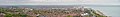 Eastbourne (England) banner Panorama.jpg 12,537 × 1,797; 8.11 MB
-
 Eastbourne - panoramio - Dawid Glawdzin (1).jpg 640 × 480; 43 KB
-
 Eastbourne - panoramio - Dawid Glawdzin (2).jpg 640 × 480; 75 KB
-
 Eastbourne - panoramio - Dawid Glawdzin (3).jpg 640 × 480; 39 KB
-
 Eastbourne - panoramio - Dawid Glawdzin (4).jpg 640 × 480; 59 KB
-
 Eastbourne - panoramio - Dawid Glawdzin (5).jpg 640 × 480; 44 KB
-
 Eastbourne - panoramio - Dawid Glawdzin.jpg 640 × 480; 62 KB
-
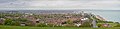 Eastbourne Panorama, England - May 2009.jpg 12,537 × 3,035; 10.57 MB
-
 Eastwards panorama from Glasgoego Farm - geograph.org.uk - 1295654.jpg 640 × 125; 125 KB
-
 Edinburgh Playhouse - geograph.org.uk - 1453731.jpg 640 × 480; 83 KB
-
 Edward VII postbox - geograph.org.uk - 1295679.jpg 426 × 640; 56 KB
-
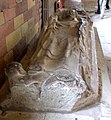 Effigy of Anian II - geograph.org.uk - 1293037.jpg 590 × 640; 190 KB
-
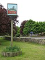 Egerton Village Sign - geograph.org.uk - 1291125.jpg 480 × 640; 86 KB
-

-

-

-
 End of the Holly Brook board-walk - geograph.org.uk - 1292203.jpg 640 × 427; 132 KB
-
 Entrance to Edinburgh Zoo - geograph.org.uk - 1298030.jpg 640 × 480; 134 KB
-
 Entrance to Highbourne Park - geograph.org.uk - 1292773.jpg 640 × 480; 79 KB
-
 Entrance to plantation in Glen Brown - geograph.org.uk - 1286806.jpg 640 × 427; 422 KB
-
 Entrance to The Dean Estate - geograph.org.uk - 1286455.jpg 640 × 427; 159 KB
-
 Entrance to The Dean Estate - geograph.org.uk - 1286457.jpg 640 × 427; 171 KB
-

-
 Eroded Peat - geograph.org.uk - 1286454.jpg 640 × 480; 125 KB
-
 Estate Track above Loch Ness - geograph.org.uk - 1285994.jpg 640 × 480; 78 KB
-

-

-
 St. Andrew's, Fairlight, East Sussex - geograph.org.uk - 1625011.jpg 480 × 640; 60 KB
-
 Farsley Scouts HQs - Newlands - geograph.org.uk - 1286230.jpg 640 × 480; 266 KB
-
 Field Farm - geograph.org.uk - 1291105.jpg 640 × 480; 65 KB
-
 Field Mill - geograph.org.uk - 1292667.jpg 640 × 480; 81 KB
-
 Fields at Fiddes - geograph.org.uk - 1294400.jpg 640 × 426; 43 KB
-
 Fields between Dean Farm and Knowle - geograph.org.uk - 1286388.jpg 640 × 427; 141 KB


_-_geograph.org.uk_-_1286239.jpg)
_-_geograph.org.uk_-_1286251.jpg)
_-_geograph.org.uk_-_1286504.jpg)
_-_geograph.org.uk_-_1286538.jpg)


_-_geograph.org.uk_-_1286133.jpg)
_-_geograph.org.uk_-_1286191.jpg)
_-_geograph.org.uk_-_1286223.jpg)
_-_geograph.org.uk_-_1286534.jpg)


_-_geograph.org.uk_-_1310539.jpg)
_-_geograph.org.uk_-_1310541.jpg)
_-_geograph.org.uk_-_1310545.jpg)
_-_geograph.org.uk_-_1310549.jpg)


.jpg)
.jpg)
.jpg)
.jpg)
.jpg)


_banner_Panorama.jpg)