Category:Urban planning
Перейти до навігації
Перейти до пошуку
Main Wikipedia article: Urban planning.
technical and political process concerned with the use of land and design of the urban environment | |||||
| Завантажити медіафайл | |||||
| Є одним із |
| ||||
|---|---|---|---|---|---|
| Є підкласом | |||||
| Частина від |
| ||||
| Підтема для |
| ||||
| Частково збігається з | |||||
| |||||
Підкатегорії
Показано 83 підкатегорії з 83.
#
*
+
-
3
- 3D city models (27 F)
A
B
- Blocked walkways (2 F)
- Braak (gronden) (4 F)
C
- Cities Alliance (1 F)
- City plans by Eliel Saarinen (15 F)
- Coving (urban planning) (4 F)
D
E
F
- Filtered permeability (16 F)
G
H
I
- Isovists (3 F)
L
M
- Mann's model (1 F)
N
- NANP code 811 (1 F)
- Neighborhood unit (3 F)
O
- Ontmanteling (1 F)
P
- Pocket Neighborhoods (2 F)
R
S
- Sector model (1 F)
T
U
- Unlimited Cities (3 F)
- Urban logistics (1 F)
- Urban spatial structure (8 F)
V
Файли в категорії «Urban planning»
Показано 200 файлів цієї категорії (із 497).
(попередня сторінка) (наступна сторінка)-
'The Fabric' Balanced Urban Development unit.jpg 662 × 497; 145 КБ
-
'The Fabric' Balanced Urban Development unit.svg 662 × 497; 26 КБ
-
1-over-1 garage parking area transparent.webp 5092 × 2098; 375 КБ
-
1-over-1 top view.webp 4818 × 2424; 530 КБ
-
141 b. Bevaringsplan Kristiania 1974.jpg 6162 × 4926; 17,45 МБ
-
1874 Albestroff Kaiserlicher Wegemeister Friedrich Deppermann.jpg 3288 × 2169; 1,7 МБ
-
20060703 Save the Point Bumper Sticker on Car (no plate-).JPG 705 × 215; 44 КБ
-
2019 City of London 3D model.jpg 3362 × 1891; 1,92 МБ
-
2D Laser Cutting Entwurf eines Hotels.jpg 481 × 308; 46 КБ
-
2D-Laser Cutting - Entwurfsdetail einer Brücke.jpg 337 × 248; 36 КБ
-
4대문안 범역 도면.png 956 × 712; 1,07 МБ
-
A conventional land development.JPG 1881 × 988; 249 КБ
-
A Short History of Traffic Engineering.jpg 3859 × 4209; 1,03 МБ
-
Accessory Dwelling Unit (ADU) Types.jpg 2057 × 1121; 952 КБ
-
Acords 1806.jpg 2217 × 1299; 2,33 МБ
-
Administrative boundary of Downtown Seoul in 2016.jpg 1944 × 2327; 791 КБ
-
Aglomeracja monocentryczna.png 506 × 418; 41 КБ
-
Algier.png 348 × 361; 21 КБ
-
Allocation of Space for Transport Infrastructure - Example of Berlin.png 4267 × 4268; 343 КБ
-
Allées de Neuilly.png 2000 × 603; 1,59 МБ
-
Am Kietz.JPG 825 × 327; 29 КБ
-
American Grid Comparison.jpg 1900 × 1900; 1,57 МБ
-
Angle parking lot diagram.PNG 540 × 400; 6 КБ
-
Annual km Travelled per Capita by car or public transport.png 4267 × 4267; 481 КБ
-
ArchetypeExample.jpg 650 × 1000; 465 КБ
-
Architecture Infographic 4.jpg 3611 × 2145; 1,45 МБ
-
Architecture Site Masterplan Miniature Scale Model.jpg 2285 × 1714; 1,23 МБ
-
Architekt Artur Paul Duniecki, Stadtteilplanung Handelskai, 1990.jpg 1200 × 772; 872 КБ
-
Argyle Street (21280451573).jpg 5760 × 3840; 28,04 МБ
-
1970 I-485-map.jpg 3317 × 3352; 1,45 МБ
-
Balanced Urban Development unit.jpg 720 × 540; 148 КБ
-
Battle axe block.svg 403 × 564; 6 КБ
-
Baufeld-le-flair.jpg 1600 × 1200; 321 КБ
-
Baumeister Stadterweiterungen.jpg 2064 × 3285; 1,2 МБ
-
Bebauungsplan Spickel.jpg 2782 × 1863; 1,43 МБ
-
Beleženje grada-beleženja vremena.Epizoda Beograd.pdf 735 × 1075, 42 сторінки; 14,18 МБ
-
Berg-fidel straßenbild.jpg 2016 × 1512; 449 КБ
-
Bikeable-map-3.jpg 2000 × 1424; 195 КБ
-
Block Sizes and Street Length-revised.png 1001 × 2112; 74 КБ
-
Block Sizes and Street Length.jpg 498 × 1051; 195 КБ
-
Block Sizes and Street Length.svg 500 × 1050; 6 КБ
-
Bloemgracht febr 2006.jpg 400 × 533; 108 КБ
-
Blum Städtebau.JPG 2665 × 3945; 2,84 МБ
-
Board of Local Improvements - City of Chicago (1921) (14593872740).jpg 1260 × 888; 399 КБ
-
Boliden TWO schematisk stadsplan 1929.jpg 556 × 622; 168 КБ
-
BOM SUCESSO 3.png 8671 × 3995; 43,7 МБ
-
Bremer Landhaus Skizze1.jpg 2733 × 3470; 1,24 МБ
-
Briefmarke Leipzig.png 484 × 289; 94 КБ
-
Bs wall.pdf 1241 × 1754; 2,23 МБ
-
BUDOTECHNIKA-SIM-Brno.jpg 1280 × 960; 222 КБ
-
BUDOTECHNIKA-SIM-gabloty.JPG 1247 × 1039; 115 КБ
-
BUDOTECHNIKA-SIM-pylony.jpg 1896 × 2033; 222 КБ
-
BUDOTECHNIKA-SIM-słupek kierunkowy z reklamą.jpg 1596 × 1851; 176 КБ
-
BUDOTECHNIKA-SIM-słupek kierunkowy.jpg 970 × 1554; 341 КБ
-
BUDOTECHNIKA-SIM-tablica.jpg 1879 × 1867; 243 КБ
-
BUDOTECHNIKA-SIM-wystawa EUROCITY2.jpg 2661 × 1854; 593 КБ
-
Build-out.jpg 400 × 400; 13 КБ
-
Burgess model.svg 512 × 203; 86 КБ
-
Bäume auf Dächer.jpg 2780 × 1852; 1,5 МБ
-
Campodeguiaplano.jpg 1931 × 1108; 2,84 МБ
-
Carrer separatiu 14m.png 3492 × 2417; 149 КБ
-
Carrer Tàpies.jpg 861 × 1772; 74 КБ
-
Carrousel Parvis.png 715 × 840; 987 КБ
-
Cars per 1000 Inhabitants.png 3718 × 4159; 415 КБ
-
Cavite Boulevard sketch by Burnham.jpg 1838 × 2518; 535 КБ
-
CENTRALE-PARIS chantier-Lavallée Chatenay-Malabry avril-2020 antoine-FILIPE-01.png 3104 × 1846; 8,45 МБ
-
Cerda-avantprojecteEixample-1955.jpg 857 × 545; 282 КБ
-
Chambre-dinfiltration-et-de-retention-Avizo-Experts-Conseils.jpg 965 × 643; 145 КБ
-
Chance of Fatality by Impact Speed.png 3764 × 4159; 388 КБ
-
Change in Urban Population and Motorisation Rate.png 3995 × 4159; 8,77 МБ
-
Chicago-trees 2.jpg 636 × 625; 120 КБ
-
Christaller.png 585 × 745; 72 КБ
-
Cisterna.JPG 960 × 1280; 123 КБ
-
City block.PNG 530 × 330; 10 КБ
-
City Development Index Armenia.png 805 × 641; 80 КБ
-
City-block2.png 400 × 195; 2 КБ
-
CityForming Protocol.jpg 3680 × 3638; 657 КБ
-
Ciudad Lineal-perfil.jpg 1256 × 331; 83 КБ
-
Clarence Perry's Neighborhood Unit, 1928.jpg 975 × 609; 290 КБ
-
Clasificación urbanística.png 1301 × 895; 1,64 МБ
-
Concentrisch model web.jpg 500 × 498; 47 КБ
-
Concord Pacific Master Plan Area.jpg 4356 × 2450; 5,93 МБ
-
Connectivity versus permeability.svg 705 × 696; 11 КБ
-
Container City 13.JPG 4320 × 3240; 4,77 МБ
-
Core frame model.svg 1134 × 489; 25 КБ
-
Core frame1.png 1445 × 1032; 50 КБ
-
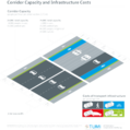
Corridor Capacity and Infrastructure Costs de.svg 1324 × 1329; 4,95 МБ
-
Corridor Capacity and Infrastructure Costs.png 4141 × 4159; 818 КБ
-
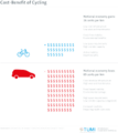
Cost-Benefit of Cycling.png 3718 × 4158; 290 КБ
-
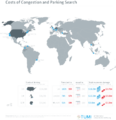
Costs of Congestion and Parking Search.png 4028 × 4159; 1,08 МБ
-
Country Chapters of African Planning Society.png 6460 × 3403; 690 КБ
-
CruillesCerda.jpg 9028 × 4073; 9,78 МБ
-
CruillesCerda2.jpg 3345 × 1833; 1,62 МБ
-
Cul-de-sac to Honeycomb.jpg 1492 × 1009; 1,12 МБ
-
Cultuurhist.model.png 647 × 586; 24 КБ
-
DallasMunicipalCenterPlan1946.jpg 1006 × 820; 125 КБ
-
Dar es Salaam Reticula.jpg 720 × 540; 91 КБ
-
Declaration préalable.png 575 × 825; 84 КБ
-
Delcevo GUP.jpg 1500 × 863; 335 КБ
-
Demmin71.jpg 487 × 175; 88 КБ
-
Demolition of Titāniks.jpg 1254 × 720; 268 КБ
-
DG GOGIS and Acting Surveyor General 01.jpg 1620 × 711; 817 КБ
-
DG GOGIS and Acting Surveyor General 02.jpg 1728 × 3936; 1,31 МБ
-
DG GOGIS and Acting Surveyor General 03.jpg 3936 × 1728; 1,13 МБ
-
DG GOGIS and Acting Surveyor General 04.jpg 3936 × 1728; 1,14 МБ
-
DG GOGIS and Acting Surveyor General 05.jpg 3936 × 1728; 1,16 МБ
-
DG GOGIS and Acting Surveyor General 06.jpg 3936 × 1728; 1,16 МБ
-
DG GOGIS and Acting Surveyor General 07.jpg 1620 × 711; 595 КБ
-
DG GOGIS and Acting Surveyor General 08.jpg 3936 × 1728; 1,75 МБ
-
DG GOGIS and Acting Surveyor General 09.jpg 3936 × 1728; 1,74 МБ
-
DG GOGIS and Acting Surveyor General 10.jpg 3936 × 1728; 1,64 МБ
-
DG GOGIS and Acting Surveyor General 11.jpg 1620 × 711; 663 КБ
-
DG GOGIS and Acting Surveyor General 12.jpg 3936 × 1728; 1,92 МБ
-
DG GOGIS and Acting Surveyor General 13.jpg 3936 × 1728; 1,6 МБ
-
DG GOGIS and Acting Surveyor General 14.jpg 3936 × 1728; 1,6 МБ
-
DG GOGIS and Acting Surveyor General 15.jpg 3936 × 1728; 1,72 МБ
-
Director General of GOGIS and Technical Team 01.jpg 3936 × 1728; 2 МБ
-
Director General of GOGIS and Technical Team 02.jpg 3936 × 1728; 1,81 МБ
-
Director General of GOGIS and Technical Team 03.jpg 3936 × 1728; 1,82 МБ
-
Director General of GOGIS and Technical Team 04.jpg 3936 × 1728; 2,01 МБ
-
Director General of GOGIS and Technical Team 05.jpg 3936 × 1728; 2,19 МБ
-
Director General of GOGIS and Technical Team 06.jpg 3936 × 1728; 2,25 МБ
-
Director General of GOGIS and Technical Team 07.jpg 3936 × 1728; 2,23 МБ
-
Director General of GOGIS and Technical Team 08.jpg 3936 × 1728; 2,12 МБ
-
Director General of GOGIS and Technical Team 09.jpg 3936 × 1728; 2,26 МБ
-
Director General of GOGIS and Technical Team 10.jpg 3936 × 1728; 2,19 МБ
-
Director General of GOGIS and Technical Team 11.jpg 3936 × 1728; 2,08 МБ
-
Director General of GOGIS and Technical Team 12.jpg 3936 × 1728; 1,94 МБ
-
Director General of GOGIS and Technical Team 13.jpg 3936 × 1728; 2,21 МБ
-
Director General of GOGIS and Technical Team 14.jpg 3936 × 1728; 2,31 МБ
-
Director General of GOGIS and Technical Team 15.jpg 3936 × 1728; 2,08 МБ
-
Director General of GOGIS and Technical Team 16.jpg 3936 × 1728; 2,01 МБ
-
Director General of GOGIS and Technical Team 17.jpg 3936 × 1728; 2,43 МБ
-
Director General of GOGIS and Technical Team 18.jpg 3936 × 1728; 2,16 МБ
-
Director General of GOGIS and Technical Team 19.jpg 3936 × 1728; 1,68 МБ
-
Director General of GOGIS and Technical Team 20.jpg 3936 × 1728; 2,64 МБ
-
Director General of GOGIS and Technical Team 21.jpg 3936 × 1728; 2,17 МБ
-
Disposisjonsplan Heimdalsbyen 1971.jpg 3026 × 2458; 2,06 МБ
-
Dortmund, Kunstautomat Hohe Straße.jpg 4608 × 2592; 2,71 МБ
-
Doxiadisekistics2.jpg 194 × 260; 7 КБ
-
DPZ SmartCode9 OptionModule ThoroughfareAssemlies Page 21.png 1342 × 1120; 24 КБ
-
Démolition bâtiment.jpg 4000 × 3000; 4,44 МБ
-
E1.ncdp.jpg 1024 × 768; 597 КБ
-
Eberstadt.JPG 2075 × 3465; 1015 КБ
-
Ecobarrio Terrafertil - Viveros huertas comunitarias.jpg 2978 × 2447; 2,99 МБ
-
Ecobarrio Terrafertil Planta de conjunto.jpg 7145 × 4803; 3,29 МБ
-
Eggarten - Siedlung.jpg 900 × 600; 498 КБ
-
EixampleBCN-projecteRovira.jpg 1548 × 1038; 777 КБ
-
Elburg after cadastral plan 1830.jpg 3634 × 3051; 2,27 МБ
-
Elements of Low-Carbon Urban Development.png 3718 × 4159; 322 КБ
-
Elements of Sustainable Mobility.png 3718 × 4158; 251 КБ
-
Energy Efficiency of different Transport Modes.png 3724 × 4159; 250 КБ
-
Enkhuizen model web.jpg 400 × 294; 23 КБ
-
Ensemble bâti-parcelle faible densité.png 396 × 232; 3 КБ
-
Ensemble bâti-parcelle haute densité.png 364 × 232; 19 КБ
-
Ensemble bâti-parcelle moyenne densité.png 399 × 232; 17 КБ
-
Ensemble bâti-parcelle très haute densité.png 309 × 232; 22 КБ
-
Entwicklungsgebiet Alter Schlachthof.png 1071 × 883; 788 КБ
-
EQC - URB053 - Caminhos Internos.jpg 1699 × 1365; 267 КБ
-
EQC - URB053 - Fachada Ativa.jpg 1699 × 1365; 263 КБ
-
EQC - URB053 - Relação público x privado.jpg 1699 × 1365; 253 КБ
-
EQC - URB053 - Unidades habitacionais compactas e flexíveis.jpg 1699 × 1365; 223 КБ
-
Erdenburg moitzfeld tor.jpg 626 × 454; 82 КБ
-
Examples of set back zoning, 1916.jpg 809 × 351; 62 КБ
-
Exhibition mount for "Evolution of measures..." Wellcome M0014874.jpg 3184 × 3386; 3,77 МБ
-
FEMA - 31031 - Community planner working to rebuild Greensubrg, KS.jpg 3000 × 2000; 3,53 МБ
-
Fenster Kietz.JPG 819 × 172; 30 КБ
-
Finca Casa-Puerta, abajo a la derecha, plano de Castro, 1861 (cropped).jpg 1243 × 977; 239 КБ
-
Floresta Ville - WEB.png 8887 × 6441; 47,21 МБ
-
Floresta Ville OK.png 3205 × 2323; 6,54 МБ
-
Flächennutzungsplan vereinfacht Koblenz.jpg 679 × 590; 119 КБ
-
Foire saint germain2.jpg 280 × 221; 21 КБ
-
Francesc Rodés.jpg 4791 × 2481; 8,27 МБ
-
Fàbrica de Gregori French.jpg 1720 × 1969; 2,67 МБ
-
E. Howard diagram dutch cropped.jpg 393 × 617; 51 КБ
-
Garden Cities.djvu 5100 × 6600, 37 сторінок; 990 КБ
-
Garden City, Port Melbourne in 1929.jpg 1079 × 581; 132 КБ
-
Geschlossene Bauweise.png 718 × 718; 76 КБ
-
Glensburg Cities Logo.png 291 × 76; 6 КБ
-
Gliesmaroder Turm 1839.jpeg 485 × 295; 39 КБ
-
GOGIS technical team at Akko 01.jpg 5184 × 3456; 7,26 МБ
-
GOGIS technical team at Akko 02.jpg 5184 × 3456; 8,03 МБ
-
GOGIS technical team at Akko 03.jpg 5184 × 3456; 6,8 МБ
-
GOGIS technical team at Akko 04.jpg 5184 × 3456; 7,66 МБ
-
GOGIS technical team at Akko 05.jpg 5184 × 3456; 9,2 МБ
-
GOGIS technical team at Akko 06.jpg 5184 × 3456; 7,53 МБ
-
GOGIS technical team at Akko 07.jpg 5184 × 3456; 9,15 МБ
-
GOGIS technical team at Akko 08.jpg 5184 × 3456; 9,66 МБ
-
GOGIS technical team at Akko 09.jpg 5184 × 3456; 9,94 МБ
-
GOGIS technical team at Akko 10.jpg 5184 × 3456; 5,53 МБ
-
GOGIS technical team at Akko 11.jpg 5184 × 3456; 5,6 МБ
-
GOGIS technical team at Akko 12.jpg 5184 × 3456; 9,41 МБ
-
GOGIS technical team at Akko 13.jpg 5184 × 3456; 7,23 МБ
-
GOGIS technical team at Akko 14.jpg 5184 × 3456; 8,04 МБ
-
GOGIS technical team at Akko 15.jpg 5184 × 3456; 6,98 МБ


