Category:Volcanological diagrams
Jump to navigation
Jump to search
Subcategories
This category has the following 35 subcategories, out of 35 total.
*
- Old volcanological diagrams (1 F)
+
- Block diagrams of volcanoes (2 F)
D
- Diagrams of mid-ocean ridges (45 F)
- Diagrams of tuff rings (1 F)
E
L
- Lava diagrams (1 F)
O
- Olivine diagrams (15 F)
R
T
- Tephra diagrams (1 F)
V
Media in category "Volcanological diagrams"
The following 200 files are in this category, out of 247 total.
(previous page) (next page)-
 20181106 Showa 5331 (48429833407).jpg 7,952 × 5,304; 29.91 MB
-

-
 5 Highest Volcanoes Worldwide (hy).svg 512 × 230; 38 KB
-

-
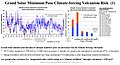 A grand solar minimum poses catastrophic volcanism risk.jpg 960 × 518; 175 KB
-
 Ages of flood basalt events 1.png 1,560 × 1,600; 192 KB
-
 Arrhenius - L’évolution des mondes, 1910 - Fig-08.jpg 2,227 × 1,179; 262 KB
-
 Arrhenius - L’évolution des mondes, 1910 - Fig-42.jpg 1,464 × 701; 81 KB
-
 Arrhenius - L’évolution des mondes, 1910 - Fig-43.jpg 1,448 × 680; 82 KB
-
 Atoll forming-Atoll.png 263 × 95; 30 KB
-
 Atoll forming-Barrier reef.png 263 × 102; 33 KB
-
 Atoll forming-Fringing reef.png 264 × 117; 33 KB
-
 Atoll forming-i18.png 1,667 × 2,423; 486 KB
-
 Atoll forming-volcano.png 263 × 194; 44 KB
-
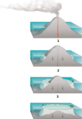
 Atoll forming.jpg 283 × 503; 21 KB
-
 Batholite-Bloc-diagrame.png 500 × 300; 5 KB
-
 Batolito.png 652 × 226; 5 KB
-
 Black Smoker Chem.svg 744 × 1,052; 180 KB
-
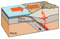 Borde convergente.png 274 × 178; 9 KB
-
 Cantal volcanoes section-fr.svg 1,880 × 1,150; 93 KB
-
 Carbonatitecrosssectionohne.svg 829 × 882; 104 KB
-
 CarbonCycle.svg 1,052 × 531; 96 KB
-
 Cinder cone diagram.gif 400 × 237; 89 KB
-

-
 Coupe cheminée hydrothermale.svg 534 × 356; 55 KB
-
 Coupe Structure volcanique en éruption C.JPG 750 × 814; 122 KB
-
 Coupe Structure volcanique légendée c.JPG 750 × 677; 113 KB
-
 Crag and tail diagram.jpg 800 × 441; 19 KB
-
 Cross section of proposed magma plumbing system beneath the surface of Kīlauea.png 2,095 × 1,001; 3.04 MB
-
 Cross-section of Mauna Kea.jpg 2,004 × 2,150; 343 KB
-
 Crustal Thinning Sequence.jpg 1,488 × 1,039; 439 KB
-
 Cryovolcanism on the Earth.png 900 × 438; 103 KB
-
 Cutaway view east rift zone Kilauea-blank.png 620 × 230; 47 KB
-
 Cutaway view east rift zone Kilauea.png 617 × 227; 34 KB
-
 Cycle orogénique Schema1.svg 1,060 × 570; 50 KB
-
 Deception-caldera-4 hg.png 1,528 × 1,141; 929 KB
-
 Deep Sea Vent Chemistry Diagram workaround.svg 2,198 × 1,266; 149 KB
-
 Deep sea vent chemistry diagram.jpg 2,199 × 1,278; 1.17 MB
-
 Denudation Model br c.jpg 901 × 478; 99 KB
-
 Denudation Model Rio de Janeiro br c.jpg 1,800 × 957; 562 KB
-
 Destructive plate margin.png 880 × 600; 65 KB
-
 Destructive plate margin.svg 880 × 600; 14 KB
-
 Diff gravitativa.svg 744 × 1,052; 445 KB
-
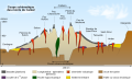
 Différenciation Matériel volcanique C.JPG 606 × 186; 12 KB
-
 Dique granítico.png 228 × 220; 2 KB
-
 Direction and Distance of Some Major Cities from Volcanoes.jpg 1,200 × 650; 117 KB
-
 Dome and Keel Structure cropped.pdf 1,516 × 656; 223 KB
-
 Dome and Keel Structure.pdf 1,752 × 1,239; 222 KB
-
 Eruption Recurrence Rates of Volcanic Fields - Graph.jpg 1,566 × 958; 297 KB
-
 Evolution of the Chiricahua Landscape.jpg 1,473 × 1,563; 449 KB
-
 Expl2289 - Flickr - NOAA Photo Library.jpg 1,790 × 1,337; 424 KB
-
 Filoni.jpg 1,315 × 914; 80 KB
-
 Formation de caldeira.png 399 × 323; 83 KB
-
 Formation of passive margins (horizontal).png 2,366 × 314; 36 KB
-
 Formation of passive margins cropped.svg 574 × 459; 103 KB
-
 Formation of passive margins.png 1,202 × 1,144; 74 KB
-
 Fractional crystallization DE.svg 800 × 341; 35 KB
-
 Fractional crystallization ES.svg 750 × 320; 98 KB
-
 Freatomagmatische Explosie.PNG 349 × 342; 7 KB
-
 Funktionsweise Geysir de.svg 252 × 311; 31 KB
-
 Funktionsweise Geysir.png 250 × 309; 6 KB
-

-

-
 Geyser diagram lmb.png 274 × 457; 39 KB
-
 Greenland sulfate ru.png 394 × 557; 18 KB
-
 Greenland sulfate-tr.png 394 × 557; 22 KB
-
 Greenland sulfate.png 394 × 557; 23 KB
-
 Hoodoo Mountain eruptive periods.png 356 × 484; 15 KB
-
 Hoạt động mácma.gif 512 × 288; 25 KB
-
 Igenous structures.jpg 315 × 180; 43 KB
-
 Igneous rock eng modified.jpg 1,442 × 1,152; 386 KB
-
 Igneous rock eng text.jpg 1,442 × 1,152; 882 KB
-
 Igneous structures.jpg 1,445 × 835; 347 KB
-
 IllustrationVolcano.png 1,091 × 819; 248 KB
-
 Inflation-deflation cycle of magma reservoirs - stage1 he.jpg 266 × 199; 15 KB
-
 Inflation-deflation cycle of magma reservoirs - stage1.jpg 266 × 199; 15 KB
-
 Inflation-deflation cycle of magma reservoirs - stage2 he.jpg 266 × 199; 20 KB
-
 Inflation-deflation cycle of magma reservoirs - stage2.jpg 266 × 199; 21 KB
-
 Inflation-deflation cycle of magma reservoirs - stage3 he.jpg 266 × 199; 19 KB
-
 Inflation-deflation cycle of magma reservoirs - stage3.jpg 266 × 199; 18 KB
-
 Intrusion types.svg 1,180 × 1,263; 72 KB
-
 Irnini Mons Hypotheses.pdf 1,562 × 781; 264 KB
-
 Irnini-Mons-Development.jpg 800 × 400; 41 KB
-
 Irnini-Mons-Formation.svg 776 × 582; 67 KB
-
 Island arc.svg 1,404 × 2,219; 61 KB
-
 Itauna SaoGoncalo.jpg 991 × 883; 107 KB
-
 Kaldera Scheme.png 571 × 446; 140 KB
-
 Kalkan volkan.png 495 × 555; 150 KB
-
 Kilauea Cross section he.jpg 700 × 351; 41 KB
-
 Kilauea eruptions in record history.png 2,880 × 806; 94 KB
-
 Kilauea Iki magma budget-en.png 607 × 460; 43 KB
-
 Krakatau trije kear.png 520 × 708; 25 KB
-
 Kīlauea eruptions in record history.svg 720 × 201; 19 KB
-
 Large eruptions - dark.jpg 1,236 × 1,155; 222 KB
-
 Largest eruptions-ru.svg 1,236 × 1,155; 625 KB
-
 Lassen hydrothermal system.jpg 531 × 488; 23 KB
-
 LIP Plate Cover He.jpg 800 × 600; 57 KB
-
 Loskvenydh skoos.jpg 1,063 × 720; 87 KB
-
 Lyell Frontispiece 1837.png 1,064 × 674; 1.19 MB
-
 Lyell Principles frontispiece.jpg 1,716 × 1,092; 407 KB
-
 LzKSK.pdf 2,320 × 2,018; 135 KB
-
 Magma chamber.png 850 × 602; 201 KB
-
 Magma Chambers.jpg 1,200 × 1,121; 136 KB
-
 Magmatism and volcanism EN.svg 1,150 × 900; 61 KB
-
 Major Eruptions Volumes Comparison.svg 385 × 271; 11 KB
-
 Mantle Plume he.png 600 × 742; 35 KB
-
 Mantleplume.png 577 × 388; 31 KB
-
 Mastin2 lakesA.gif 500 × 391; 62 KB
-
 Mazama collapse phase 1.jpg 250 × 211; 7 KB
-
 Mid-ocean ridge topography.gif 240 × 180; 1.06 MB
-
 Mount Mazama eruption timeline 1.svg 1,049 × 822; 26 KB
-
 Mount Mazama eruption timeline 2.svg 1,049 × 822; 26 KB
-
 Mount Mazama eruption timeline 3.svg 1,049 × 822; 23 KB
-
 Mount Mazama eruption timeline 4.svg 1,049 × 822; 48 KB
-
 Mount Mazama eruption timeline gl.png 250 × 841; 202 KB
-
 Mount Mazama eruption timeline.PNG 250 × 841; 187 KB
-
 Mshelen.gif 450 × 380; 4.7 MB
-
 Na de uitbarsting, Bestanddeelnr 193-0333.jpg 3,228 × 2,011; 1.15 MB
-
 Nazko Cone side view.png 699 × 330; 49 KB
-
 Newberry-Yellowstone tracks.png 536 × 326; 19 KB
-
 Non-Volcanic Passive Margin Cross Section.jpg 950 × 603; 234 KB
-
 Núi lửa phun trào.jpg 590 × 308; 31 KB
-
 Oceanic spreading-hu.svg 600 × 450; 37 KB
-
 Oceanic-continental convergence Fig21oceancont (dumb version).png 450 × 265; 344 KB
-
 Oceanic-continental convergence Fig21oceancont (french).png 450 × 265; 108 KB
-
 Oceanic-continental convergence Fig21oceancont.gif 302 × 178; 14 KB
-
 Oceanic-continental convergence.svg 710 × 417; 375 KB
-
 Oceanic-oceanic convergence-rus.png 301 × 156; 24 KB
-
 OlympusMons MaunaKea Everest diagram-fr.svg 690 × 400; 21 KB
-
 OlympusMons MaunaKea Everest diagram-nl.svg 690 × 400; 24 KB
-
 Ophiolite suite scheme.jpg 826 × 634; 150 KB
-
 Page 331-cruiseofcorwin2.jpg 676 × 684; 215 KB
-
 Page 339-cruiseofcorwin.jpg 765 × 240; 90 KB
-
 Partial melting asthenosphere EN.svg 1,000 × 600; 92 KB
-
 Partial melting asthenosphere FR.svg 1,000 × 600; 91 KB
-
 Pasos CR CVC.svg 1,417 × 339; 31 KB
-
 Phacolith.jpg 786 × 563; 35 KB
-
 Plume-schematisch.png 2,490 × 2,148; 37 KB
-
 Pressione taglio magmi.svg 647 × 592; 193 KB
-
 Prisma de acrecion lmb rg.jpg 264 × 167; 45 KB
-
 Prisma de acrecion lmb.png 264 × 167; 9 KB
-
 Proterozoic Superior craton dike swarms.png 733 × 574; 313 KB
-
 PSM V19 D062 Crater of deposition.jpg 1,340 × 430; 71 KB
-
 PSM V19 D063 Crater of upheaval.jpg 1,522 × 543; 107 KB
-
 PSM V20 D056 Stromboli crater on the april 24 1874 eruption.jpg 1,363 × 812; 320 KB
-
 PSM V20 D059 Section of the kammerbuhl in bohemia.jpg 1,608 × 509; 135 KB
-
 PSM V20 D061 Outlines of lava cones.jpg 1,389 × 540; 26 KB
-
 PSM V20 D062 Outlines of the summit of vesuvius in the eruption of 1767.jpg 1,372 × 2,051; 154 KB
-

-
 PSM V20 D372 Section of the mull vulcano along line ab.jpg 1,434 × 412; 69 KB
-
 PSM V21 D384 The great geyser of bjarnafell iceland.jpg 1,029 × 1,062; 347 KB
-
 Regional magmatism heb.jpg 3,057 × 738; 217 KB
-
 Ridge render ru.jpg 350 × 179; 12 KB
-
 Ridge render-ja.jpg 350 × 179; 23 KB
-
 Ridge Render-pt.svg 349 × 177; 25 KB
-
 Ridge render.jpg 350 × 179; 12 KB
-
 Rock contact metamorphism eng big text.jpg 1,088 × 684; 409 KB
-
 SAR Kilauea topo interferogram.jpg 577 × 577; 152 KB
-
 Seamount 2.svg 597 × 674; 25 KB
-
 Seamount.svg 597 × 674; 16 KB
-
 SeamountAlt.svg 744 × 1,052; 29 KB
-
 Shield volcano heb.png 275 × 200; 26 KB
-
 Shield volcano lmb.png 275 × 200; 28 KB
-
 Short Instrumental Temperature Record.png 510 × 359; 23 KB
-
 Ssis InSAR may2001.jpg 1,081 × 878; 197 KB
-
 StHelen eruption sequence.svg 250 × 500; 85 KB
-
 Stock (Geology).jpg 800 × 600; 28 KB
-
 Stratovolcano cross-section.svg 744 × 460; 184 KB
-
 Subduction Convergence Océan Continent.png 732 × 265; 113 KB
-
 Subduction.svg 1,052 × 531; 76 KB
-
 Sự hình thành rạn san hô vòng.png 283 × 546; 84 KB
-
 Tectonic plate boundaries2.png 735 × 417; 88 KB
-
 Teideform.gif 790 × 979; 42 KB
-
 Teideform.svg 789 × 978; 52 KB
-
 Teideform2.png 588 × 700; 58 KB
-
 Tenerife formation.png 250 × 1,000; 174 KB
-

-

-
 Tinajo - Montaña Colorada - Lapilli mine 01 ies.jpg 3,888 × 2,592; 1.52 MB
-
 Tinajo - Montaña Colorada - Lava 01 ies.jpg 3,888 × 2,592; 1.71 MB
-
 Tinajo - Montaña Colorada - Lava 05 ies.jpg 3,888 × 2,592; 1.91 MB
-
 Tinajo - Montaña Colorada - Olivine xenoliths 01 ies.jpg 3,888 × 2,592; 1.56 MB
-
 Tinajo - Montaña Colorada - Volcanic bombs 01 ies.jpg 3,888 × 2,592; 1.58 MB
-
 Tinajo - Montaña Ortiz (Montaña Colorada) 01 ies.jpg 3,888 × 2,592; 1.72 MB
-
 TOMS SO2 time nov03.png 839 × 500; 166 KB
-
 Toms-sulfur-from-volcanos-1979-2003.gif 1,045 × 755; 27 KB
-
 Tonga aerosol layers over Texas 14 Apr 2022.jpg 1,593 × 2,628; 403 KB
-
 Tonga cal 2022016.jpg 720 × 296; 85 KB
-
 Topographic Profiles of Galapagos Volcanoes.jpg 1,541 × 424; 181 KB
-
-
 Types of volcano hazards usgs.gif 335 × 390; 18 KB
-
 Types of volcanoes and eruption features.jpg 3,523 × 962; 1.18 MB
-
 Underwater Volcanic Eruption (3704449319).jpg 500 × 345; 57 KB
-
 USGSLavaDeltaCartoon.JPG 400 × 300; 22 KB
-
 UWETilt.gif 346 × 209; 7 KB
-
 VEIfigure af.svg 744 × 900; 33 KB
-
 VEIfigure bg.png 2,894 × 4,093; 1.25 MB
-
 VEIfigure en.svg 744 × 900; 29 KB
-
 VEIfigure he.jpg 424 × 600; 49 KB
-
 VEIfigure he.svg 744 × 910; 36 KB
.jpg)
.jpg)
.svg)


.jpg)


.png)
.png)


.jpg)


_01_ies.jpg)


_(14780420874).jpg)

.jpg)


.png)