Category:Watermolen Deurne
Jump to navigation
Jump to search
| Object location | | View all coordinates using: OpenStreetMap |
|---|
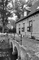
watermill in Deurne, Netherlands  | |||||
| Upload media | |||||
| Instance of | |||||
|---|---|---|---|---|---|
| Location | Deurne, North Brabant, Netherlands | ||||
| Located in or next to body of water | |||||
| Street address |
| ||||
| Heritage designation |
| ||||
| Source of energy | |||||
 | |||||
|
This is a category about rijksmonument number 12368
|
| Address |
|
Media in category "Watermolen Deurne"
The following 10 files are in this category, out of 10 total.
-
 Exterieur ACHTERGEVEL - Deurne - 20289514 - RCE.jpg 1,200 × 795; 305 KB
-
 Exterieur ACHTERGEVEL - Deurne - 20289521 - RCE.jpg 1,200 × 788; 279 KB
-
 Exterieur OVERZICHT - Deurne - 20289515 - RCE.jpg 1,200 × 784; 244 KB
-
 Exterieur RECHTER ZIJGEVEL - Deurne - 20289520 - RCE.jpg 1,200 × 788; 320 KB
-
 Exterieur VOORGEVEL - Deurne - 20289516 - RCE.jpg 780 × 1,200; 236 KB
-
 Exterieur VOORGEVEL - Deurne - 20289517 - RCE.jpg 1,200 × 788; 255 KB
-
 Exterieur VOORGEVEL - Deurne - 20289518 - RCE.jpg 1,200 × 798; 232 KB
-
 Exterieur VOORGEVEL - Deurne - 20289519 - RCE.jpg 788 × 1,200; 328 KB
-
 Watergedreven molen met onderslagrad - Deurne - 20053795 - RCE.jpg 1,200 × 803; 290 KB
-
 WatermolenDeurne.jpg 1,600 × 1,200; 446 KB


