Category:Whitgift Lighthouse
Jump to navigation
Jump to search
| Object location | | View all coordinates using: OpenStreetMap |
|---|
This is a category about listed building number 1346751. |
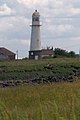
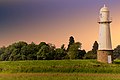
English: Whitgift Lighthouse
lighthouse in Twin Rivers, East Riding of Yorkshire, England, UK  | |||||
| Upload media | |||||
| Instance of | |||||
|---|---|---|---|---|---|
| Made from material | |||||
| Location | Whitgift, Twin Rivers, East Riding of Yorkshire, Yorkshire and the Humber, England | ||||
| Operator | |||||
| Heritage designation |
| ||||
| Height |
| ||||
 | |||||
Media in category "Whitgift Lighthouse"
The following 17 files are in this category, out of 17 total.
-

-
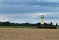
 Humberside fields - geograph.org.uk - 56497.jpg 640 × 436; 60 KB
-
 Looking towards Whitgift Lighthouse - geograph.org.uk - 507471.jpg 425 × 640; 140 KB
-
 The River Ouse at Whitgift - geograph.org.uk - 697984.jpg 640 × 480; 66 KB
-

-
 Whitgift Lighthouse - geograph.org.uk - 1970387.jpg 350 × 522; 159 KB
-
 Whitgift Lighthouse - geograph.org.uk - 1971563.jpg 350 × 522; 145 KB
-
 Whitgift Lighthouse - geograph.org.uk - 1971566.jpg 800 × 543; 487 KB
-
 Whitgift lighthouse - geograph.org.uk - 2510171.jpg 1,024 × 734; 150 KB
-
 Whitgift lighthouse - geograph.org.uk - 933858.jpg 640 × 434; 61 KB
-
 Whitgift lighthouse from Yokefleet - geograph.org.uk - 482828.jpg 427 × 640; 69 KB
-

-
 Whitgift Lighthouse Sunset @ Bob Riach.jpg 5,438 × 3,626; 4.34 MB
-

-
 Whitgift Lighthouse. - geograph.org.uk - 1223591.jpg 640 × 480; 39 KB
-
 Whitgift Lighthouse.jpg 640 × 427; 101 KB
-
 Whitgift Roads - geograph.org.uk - 635714.jpg 640 × 460; 80 KB


