Category:Woodenbridge
Jump to navigation
Jump to search
town in Leinster, Ireland  | |||||
| Upload media | |||||
| Instance of | |||||
|---|---|---|---|---|---|
| Location | County Wicklow, Leinster, Ireland | ||||
| Elevation above sea level |
| ||||
 | |||||
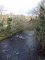
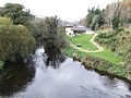
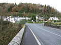
English: Woodenbridge, historically known as Garragowlan , is a small village in County Wicklow, Ireland, located between Arklow and Avoca, at the meeting of the Avoca, Aughrim and Goldmine rivers. The village is located at the junction of the R747 and R752 roads. The R747 crosses the Aughrim River on the stone bridge (see photo) which is still called "Wooden Bridge".
Media in category "Woodenbridge"
The following 21 files are in this category, out of 21 total.
-
 EMO Petrol Station Woodenbridge - geograph.org.uk - 1048722.jpg 640 × 480; 101 KB
-
 Goldmines River, Co. Wicklow - geograph.org.uk - 150878.jpg 640 × 422; 69 KB
-
 IMG WoodenbridgeHotel1612.jpg 3,456 × 2,338; 2.89 MB
-
 The Aughrim River - geograph.org.uk - 627742.jpg 480 × 640; 100 KB
-
 The Aughrim River - view upstream - geograph.org.uk - 627756.jpg 640 × 480; 86 KB
-
 The Woodenbridge Hotel - geograph.org.uk - 627763.jpg 640 × 480; 99 KB
-
 The Woodenbridge Hotel - geograph.org.uk - 705796.jpg 640 × 480; 72 KB
-
 Valley of Goldmine Tributary - geograph.org.uk - 744892.jpg 480 × 640; 67 KB
-
 View from the Woodenbridge Hotel - geograph.org.uk - 705793.jpg 640 × 374; 78 KB
-
 View towards Glenoge - geograph.org.uk - 705801.jpg 640 × 480; 115 KB
-
 Wooden Bridge - geograph.org.uk - 627740.jpg 640 × 480; 146 KB
-
 Woodenbridge.jpg 3,888 × 2,592; 3.35 MB
-
 Confluence of Goldmine and Tributary. - geograph.org.uk - 744943.jpg 640 × 480; 159 KB
-
 Forestry Road and Goldmine Valley. - geograph.org.uk - 744950.jpg 480 × 640; 59 KB
-
 Forestry Track in Goldmine Valley. - geograph.org.uk - 744920.jpg 480 × 640; 95 KB
-
 Goldmine River - geograph.org.uk - 744912.jpg 480 × 640; 152 KB
-
 Goldmine River. - geograph.org.uk - 744904.jpg 480 × 640; 152 KB
-
 Goldmine Valley - geograph.org.uk - 744959.jpg 480 × 640; 166 KB
-
 Local road to Kilcara East - geograph.org.uk - 627773.jpg 640 × 480; 121 KB
-
 Slievefoore - geograph.org.uk - 705803.jpg 640 × 339; 71 KB
-
 White Heaps - geograph.org.uk - 705807.jpg 640 × 480; 125 KB


