File:Plan de Paris vers 1550 color.jpg
Jump to navigation
Jump to search
Size of this preview: 800 × 582 pixels. Other resolutions: 320 × 233 pixels | 640 × 466 pixels | 1,024 × 745 pixels | 1,280 × 931 pixels | 2,560 × 1,863 pixels | 6,108 × 4,444 pixels.
Original file (6,108 × 4,444 pixels, file size: 23.18 MB, MIME type: image/jpeg)
Captions
Captions
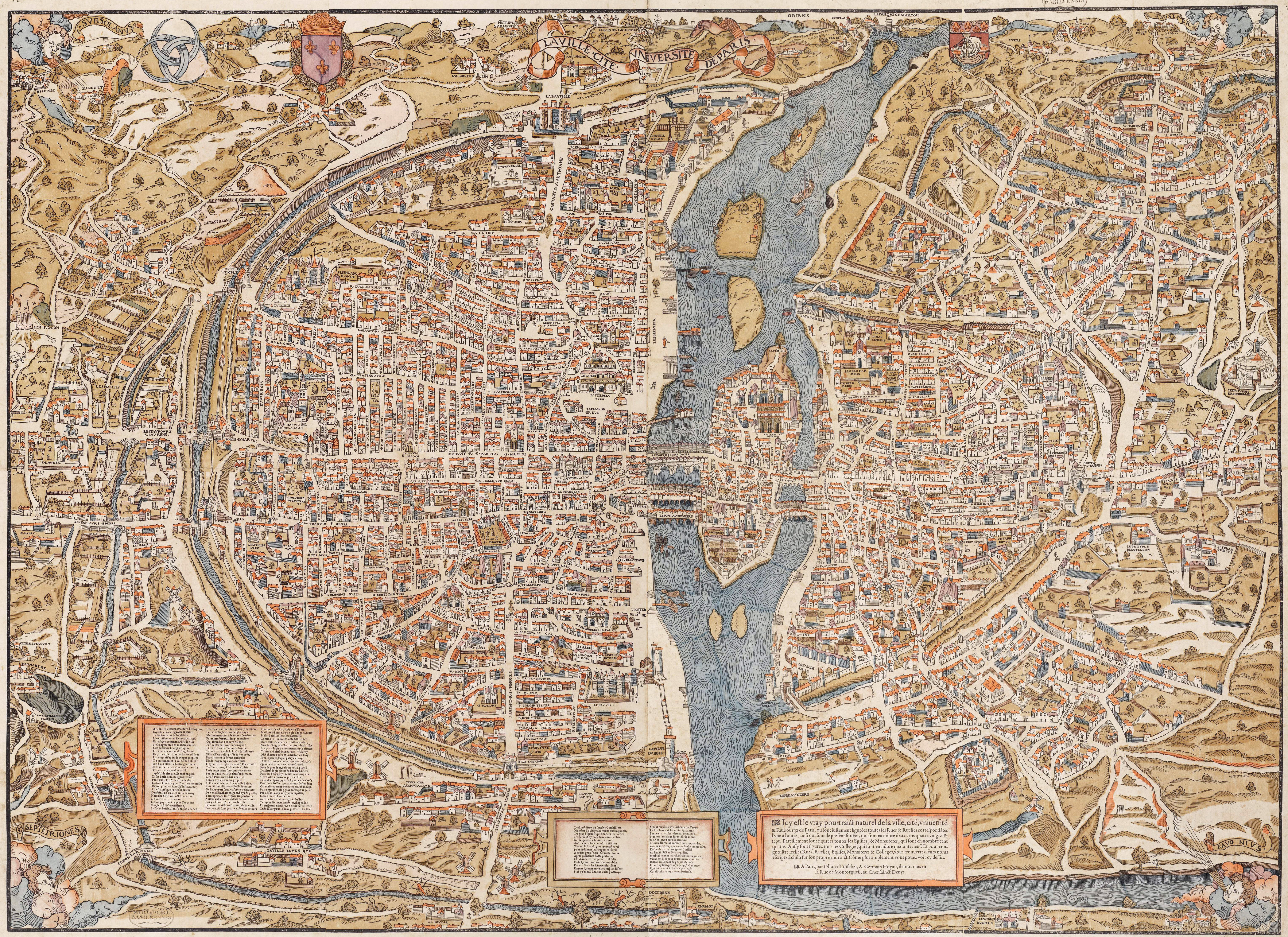
Sixteenth-century woodcut map of Paris.
Summary
[edit]| Description |
English: Plan of Paris by Truschet et Hoyau, scale ca. 1:4,500 (94 x 120 cm). Seefeld (Zurich) published this 1980 facsimile of the original map, also known as the plan de Bâle (Basel plan). Boutier gives a date of c. 1553 and estimates a scale of c. 1:7,000. The original is in color and was engraved on wood, 8 plates, 96 x 133 cm assembled.
Français : Le plan de Paris par Truschet et Hoyau, La ville, cité, université de Paris, échelle 1:4 500 environ (facsimile Seefeld, Zürich 1980). |
| References |
|
| Date | circa 1550 |
| Source | NL, Universiteitsbibliotheek Vrije Universiteit, LL.06979gk: 130/od/1550; http://imagebase.ubvu.vu.nl/getobj.php?ppn=330025988 |
| Creator |
Olivier Truschet, engraver (?) Germain Hoyau, designer (?) |
| Georeferencing | If inappropriate please set warp_status = skip to hide. |
| Other versions |
|

|
Licensing
[edit]
|
This work is in the public domain in its country of origin and other countries and areas where the copyright term is the author's life plus 100 years or fewer. | |
| This file has been identified as being free of known restrictions under copyright law, including all related and neighboring rights. | |
File history
Click on a date/time to view the file as it appeared at that time.
| Date/Time | Thumbnail | Dimensions | User | Comment | |
|---|---|---|---|---|---|
| current | 12:17, 30 May 2011 | | 6,108 × 4,444 (23.18 MB) | FA2010 (talk | contribs) | {{Information |Description=Le plan de Paris par Truschet et Hoyau, ''La ville, cité, université de Paris'', ca. 1:4.500 (facsimile Seefeld, Zürich 1980) |Source=NL, Universiteitsbibliotheek Vrije Universiteit, LL.06979gk: 130/od/1550; http://imagebase. |
You cannot overwrite this file.
File usage on Commons
The following 75 pages use this file:
- Maps of Paris
- User:FA2010/gallery4
- User:Nclm/Favorites
- User:Samsara/POTY 2011 overview
- User:Ö/Best/2011
- Commons:Featured picture candidates/File:Plan de Paris vers 1550 color.jpg
- Commons:Featured picture candidates/Log/December 2011
- Commons:Featured picture candidates/Log/November 2011
- Commons:Featured picture candidates/Log/October 2017
- Commons:Featured picture candidates/removal/File:Plan de Paris vers 1550 color.jpg
- Commons:Featured picture candidates/removal/File:Plan de Paris vers 1550 color.jpg/1
- Commons:Featured pictures/chronological/2011-B
- Commons:Featured pictures/chronological/2017-B
- Commons:Picture of the Year/2011/Galleries/2011-B
- Commons:Picture of the Year/2011/Galleries/ALL
- Commons:Picture of the Year/2011/Galleries/B
- Commons:Picture of the Year/2011/Galleries/B/table
- Commons:Picture of the Year/2011/Galleries/Diagrams
- Commons:Picture of the Year/2011/Galleries/Diagrams/Large
- Commons:Picture of the Year/2011/Galleries/Diagrams/Small
- Commons:Picture of the Year/2011/Galleries/Index/11
- Commons:Picture of the Year/2011/Galleries/Index/ALL
- Commons:Picture of the Year/2011/Galleries/Index/Diagrams
- Commons:Picture of the Year/2011/Galleries/NOV
- Commons:Picture of the Year/2011/Galleries/table
- Commons:Picture of the Year/2011/R1/Plan de Paris vers 1550 color.jpg
- Commons:Picture of the Year/2011/Results/R1/ALL/table
- Commons:Picture of the Year/2011/Results/R1/Diagrams
- Commons:Picture of the Year/2011/Results/R1/Diagrams/table
- Commons talk:Picture of the Year/2011/Results/R1/ALL/table
- File:1550 Paris St-Germain-Auxerrois.jpg
- File:Grange Bateliere & Porcherons (Truschet).jpg
- File:Les 3 tours (Paris).jpg
- File:Plan de Paris vers 1550.jpg
- File:Plan de Paris vers 1550 Gibet de Montfaucon.jpg
- File:Plan de Paris vers 1550 Halles.jpg
- File:Plan de Paris vers 1550 Petit pont.jpg
- File:Plan de Paris vers 1550 Pont ND.jpg
- File:Plan de Paris vers 1550 Pont au change.jpg
- File:Plan de Paris vers 1550 Rue Montmartre.jpg
- File:Plan de Paris vers 1550 St-Jacques de la boucherie.jpg
- File:Plan de Paris vers 1550 St-Medart Bievre.jpg
- File:Plan de Paris vers 1550 Tour Barbeau.jpg
- File:Plan de Paris vers 1550 abbaye-St-Martin-des-champs.jpg
- File:Plan de Paris vers 1550 college de Navarre.jpg
- File:Plan de Paris vers 1550 color eglise Saint-Andre-des-arts.jpg
- File:Plan de Paris vers 1550 color tour de Billy disparue.jpg
- File:Plan de Paris vers 1550 eglise Saint-Jacques-du-Haut-Pas.jpg
- File:Plan de Paris vers 1550 eglise St-Eustache.jpg
- File:Plan de Paris vers 1550 eglise St-Gervais.jpg
- File:Plan de Paris vers 1550 eglise St-Julien.jpg
- File:Plan de Paris vers 1550 eglise St-Marcel.jpg
- File:Plan de Paris vers 1550 eglise St-Merri.jpg
- File:Plan de Paris vers 1550 eglise des Blancs-Manteaux.jpg
- File:Plan de Paris vers 1550 hotel-Dieu.jpg
- File:Plan de Paris vers 1550 place Maubert.jpg
- File:Plan de Paris vers 1550 pont St-Michel.jpg
- File:Plan de Paris vers 1550 porte Bordelle.jpg
- File:Plan de Paris vers 1550 porte Montmartre.jpg
- File:Plan de Paris vers 1550 porte St-Antoine.jpg
- File:Plan de Paris vers 1550 porte St-Denis.jpg
- File:Plan de Paris vers 1550 porte St-Germain.jpg
- File:Plan de Paris vers 1550 porte St-Honore.jpg
- File:Plan de Paris vers 1550 porte St-Jacques.jpg
- File:Plan de Paris vers 1550 porte St-Martin.jpg
- File:Plan de Paris vers 1550 porte St-Michel.jpg
- File:Plan de Paris vers 1550 porte St-Victor.jpg
- File:Plan de Paris vers 1550 porte de Buci.jpg
- File:Plan de Paris vers 1550 porte du Chaume.jpg
- File:Plan de Paris vers 1550 porte du Temple.jpg
- File:Plan de Paris vers 1550 rue St-Paul.jpg
- File:Plan de Paris vers 1550 village Popincourt.jpg
- File:Ponts de l'ile de la Cité (1550).jpg
- File:Pre-aux-Clercs sur le plan de Truschet & Hoyau.jpg
- File:THplanbièvre.jpg
.jpg)
.jpg)
.jpg)
File usage on other wikis
The following other wikis use this file:
- Usage on az.wikipedia.org
- Paris orta əsrlərdə
- Vikipediya:Həftənin seçilmiş məqaləsi/iyun 2016
- Vikipediya:Həftənin seçilmiş məqaləsi/23. Həftə 2016
- Vikipediya:Həftənin seçilmiş məqaləsi/iyul 2018
- Vikipediya:Həftənin seçilmiş məqaləsi/29. Həftə 2018
- Vikipediya:Həftənin seçilmiş məqaləsi/iyul 2022
- Vikipediya:Həftənin seçilmiş məqaləsi/29. Həftə 2022
- Usage on en.wikipedia.org
- Usage on es.wikipedia.org
- Usage on fr.wikipedia.org
- Usage on ha.wikipedia.org
- Usage on ja.wikipedia.org
- Usage on nl.wikipedia.org
- Usage on tr.wikipedia.org
- Usage on uk.wikipedia.org
- Usage on vi.wikipedia.org