File:Адміністративна карта Роменської округи УСРР 1925.jpg
Jump to navigation
Jump to search

Size of this preview: 618 × 599 pixels. Other resolutions: 247 × 240 pixels | 495 × 480 pixels | 792 × 768 pixels | 1,056 × 1,024 pixels | 2,112 × 2,048 pixels | 3,192 × 3,096 pixels.
Original file (3,192 × 3,096 pixels, file size: 5.33 MB, MIME type: image/jpeg)
Captions
Captions
Add a one-line explanation of what this file represents
Summary[edit]
| Description |
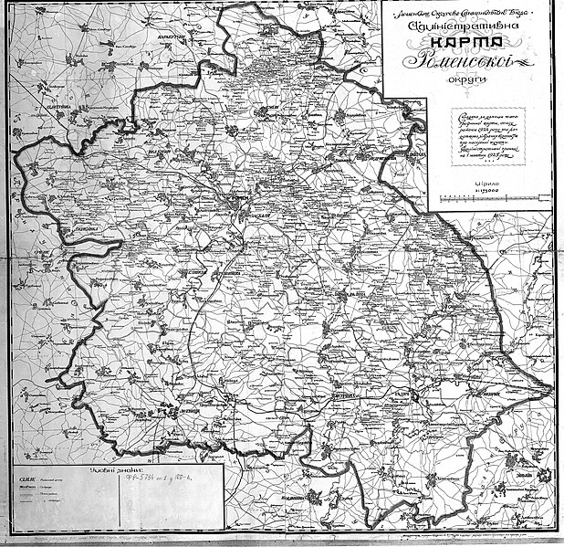
Українська: Адміністративна карта Роменської округи, 1925 |
| Date | |
| Source | Адміністративна карта Роменської округи УСРР : адм. границі — на 1 жовт. 1925 р. / Ромен. Окр. Стат. Бюро ; землеміри [В. Я.] Сухина, А. І. Бомура, ред. [В. Я.] Чорногор. — 1:175 000. — [Полтава] : Б. вид-ва, 1926. — 1 к. (2 арк.) : 3 колір. ; 67х36 см // [СК НБУВ, інв. № 9312.] [Державний архів Сумської області. Ф. Р-5734. Оп. 1. Спр. 188-А. (згідно з написом на карті)] |
| Author | Ромен. Окр. Стат. Бюро ; землеміри [В. Я.] Сухина, А. І. Бомура, ред. [В. Я.] Чорногор |
Licensing[edit]
This file is a Ukrainian or Ukrainian SSR work and it is presently in the public domain in Ukraine, because it was published before January 1, 1954, and the creator (if known) died before that date (details).
|
 |
File history
Click on a date/time to view the file as it appeared at that time.
| Date/Time | Thumbnail | Dimensions | User | Comment | |
|---|---|---|---|---|---|
| current | 08:53, 25 May 2022 | | 3,192 × 3,096 (5.33 MB) | AMY 81-412 (talk | contribs) | == {{int:filedesc}} == {{Information |description={{uk|1=Адміністративна карта Роменської округи, 1925}} |date=1925 |source= [][УСРР] : адм. границі — на 1 жовт. 1925 р.] / Ромен. Окр. Стат. Бюро ; землеміри [В. Я.] Сухина, А. І. Бомура, ред. [В. Я.] Чорногор. — 1:175 000. — [Полтава] : Б. вид-ва, 1926. — 1 к. (2 арк.) : 3 колір. ; 67х36 см // [СК НБУВ, інв. № 9312.] |author= Ромен. Окр. Стат. Бюро ; землеміри [В. Я.] Сухина, А. І. Бомура, ред. [В. Я.] Чорногор |permission= |other versio... |
You cannot overwrite this file.
File usage on Commons
There are no pages that use this file.
File usage on other wikis
The following other wikis use this file:
- Usage on ru.wikipedia.org
- Usage on uk.wikipedia.org
- Usage on uk.wikisource.org
- Usage on www.wikidata.org