File:Рожевий ранок в Ґорґанах.jpg
Jump to navigation
Jump to search

Size of this preview: 800 × 533 pixels. Other resolutions: 320 × 213 pixels | 640 × 427 pixels | 1,024 × 683 pixels | 1,280 × 853 pixels | 2,560 × 1,707 pixels | 6,000 × 4,000 pixels.
Original file (6,000 × 4,000 pixels, file size: 15.14 MB, MIME type: image/jpeg)
Captions
Captions
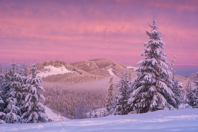
Pink morning in the Gorgany mountains, Ukraine
Summary[edit]
| Description |
English: Winter morning in the Gorgany mountain range, Nadvirna Raion, Ivano-Frankivsk Oblast, Ukraine
Čeština: Zimní ráno v chráněném horském území Gorgany Nature Reserve v ukrajinském Nadvirenském rajónu v Ivanofrankivské oblasti
Español: Mañana de invierno en la cordillera de Gorgany, raión de Nadvirna, óblast de Ivano-Frankivsk, Ucrania
Français : Matin rose d'hiver dans la chaîne de montagnes Gorgany, dans le district de Nadvirna, oblast d'Ivano-Frankivsk, en Ukraine
Português: Manhã de inverno na cordilheira Gorgany, distrito de Nadvirna, região de Ivano-Frankivsk, Ucrânia
Українська: Природний заповідник «Ґорґани», Надвірнянський район, Поляницька та Пасічнянська сільські громади, Україна
|
||
| Date | Taken on 20 December 2018, 08:00:54 | ||
| Source | Own work | ||
| Author | Vitalii Bashkatov |
| Camera location | | View this and other nearby images on: OpenStreetMap |
|---|
This image was uploaded as part of Wiki Loves Earth 2020.
|
 |
Licensing[edit]
I, the copyright holder of this work, hereby publish it under the following license:
This file is licensed under the Creative Commons Attribution-Share Alike 4.0 International license.
- You are free:
- to share – to copy, distribute and transmit the work
- to remix – to adapt the work
- Under the following conditions:
- attribution – You must give appropriate credit, provide a link to the license, and indicate if changes were made. You may do so in any reasonable manner, but not in any way that suggests the licensor endorses you or your use.
- share alike – If you remix, transform, or build upon the material, you must distribute your contributions under the same or compatible license as the original.
Assessment[edit]
|
This image was selected as picture of the day on Wikimedia Commons for 7 January 2023. It was captioned as follows: English: Winter morning in the Gorgany mountain range, Nadvirna Raion, Ivano-Frankivsk Oblast, Ukraine Other languages:
Čeština: Zimní ráno v chráněném horském území Gorgany Nature Reserve v ukrajinském Nadvirenském rajónu v Ivanofrankivské oblasti English: Winter morning in the Gorgany mountain range, Nadvirna Raion, Ivano-Frankivsk Oblast, Ukraine Español: Mañana de invierno en la cordillera de Gorgany, raión de Nadvirna, óblast de Ivano-Frankivsk, Ucrania Français : Matin rose d'hiver dans la chaîne de montagnes Gorgany, dans le district de Nadvirna, oblast d'Ivano-Frankivsk, en Ukraine Português: Manhã de inverno na cordilheira Gorgany, distrito de Nadvirna, região de Ivano-Frankivsk, Ucrânia |
File history
Click on a date/time to view the file as it appeared at that time.
| Date/Time | Thumbnail | Dimensions | User | Comment | |
|---|---|---|---|---|---|
| current | 20:16, 1 July 2020 | | 6,000 × 4,000 (15.14 MB) | Vitalii Bashkatov (talk | contribs) | Uploaded own work with UploadWizard |
You cannot overwrite this file.
File usage on Commons
The following 39 pages use this file:
- User:Andrew J.Kurbiko/POTD/2023
- User:Designermadsen/Favorites
- User:Kaldari/PotdFullYear/January
- User:Meiræ/23
- User:Radomianin/FPs by other authors
- User talk:Radomianin/Archive 1
- User talk:Vitalii Bashkatov
- Commons:Featured picture candidates/File:Рожевий ранок в Ґорґанах.jpg
- Commons:Featured picture candidates/Log/May 2022
- Commons:Featured pictures/Places/Natural
- Commons:Featured pictures/chronological/2022-A
- Commons:Featured pictures/chronological/May 2022
- Commons:Picture of the Year/2022/Candidates
- Commons:Picture of the Year/2022/R1/Gallery/2022-A
- Commons:Picture of the Year/2022/R1/Gallery/ALL
- Commons:Picture of the Year/2022/R1/Gallery/M05
- Commons:Picture of the Year/2022/R1/Gallery/Nature views
- Commons:Picture of the Year/2022/R1/v/Рожевий ранок в Ґорґанах.jpg
- Commons:Quality images/Subject/Sunsets
- Commons:Quality images candidates/Archives May 06 2022
- Commons:Wiki Loves Earth 2020 in Ukraine/Vian
- File:Digest December - January 2023.png
- Template:Potd/2023-01
- Template:Potd/2023-01-07
- Template:Potd/2023-01-07 (cs)
- Template:Potd/2023-01-07 (de)
- Template:Potd/2023-01-07 (en)
- Template:Potd/2023-01-07 (es)
- Template:Potd/2023-01-07 (fr)
- Template:Potd/2023-01-07 (hu)
- Template:Potd/2023-01-07 (mk)
- Template:Potd/2023-01-07 (myv)
- Template:Potd/2023-01-07 (nl)
- Template:Potd/2023-01-07 (pl)
- Template:Potd/2023-01-07 (pt)
- Template:Potd/2023-01-07 (pt-br)
- Template:Potd/2023-01-07 (ru)
- Template:Potd/2023-01-07 (sl)
- Template:Potd/2023-01-07 (uk)
File usage on other wikis
The following other wikis use this file:
- Usage on bn.wikipedia.org
- Usage on cv.wikipedia.org
- Usage on dv.wikipedia.org
- Usage on en.wikipedia.org
- Usage on et.wikipedia.org
- Usage on fr.wikipedia.org
- Usage on hsb.wikipedia.org
- Usage on hu.wikipedia.org
- Usage on jv.wikipedia.org
- Usage on kk.wikipedia.org
- Usage on ko.wikipedia.org
- Usage on lbe.wikipedia.org
- Usage on mk.wikipedia.org
- Usage on os.wikipedia.org
- Usage on pt.wikipedia.org
- Usage on ru.wikipedia.org
- Usage on sah.wikipedia.org
- Usage on uk.wikipedia.org
- Usage on uz.wikipedia.org
- Usage on vep.wikipedia.org
- Usage on zh.wikipedia.org
Metadata
Categories:
- Clouds and blue sky in Ukraine
- Clouds at sunrise in Ukraine
- Forests in winter
- Gorgany Nature Reserve
- Landscapes of Ivano-Frankivsk Oblast
- Mountains at sunrise in Ukraine
- Mountains with clouds in Ukraine
- Mountains with snow in Ukraine
- Pink clouds
- Pink sunrises of Ukraine
- Snowy landscapes in Ukraine
- Sunrises of Ivano-Frankivsk Oblast
- Trees in Ivano-Frankivsk Oblast
- Trees in snow in Ukraine
- December 2018 in Ivano-Frankivsk Oblast