File:《Kaartje van Tamsuy en omleggende dorpen, zoo mede het eilandje Kelang》.jpg

Original file (3,206 × 2,290 pixels, file size: 1.91 MB, MIME type: image/jpeg)
Captions
Captions
Summary
[edit]| Description |
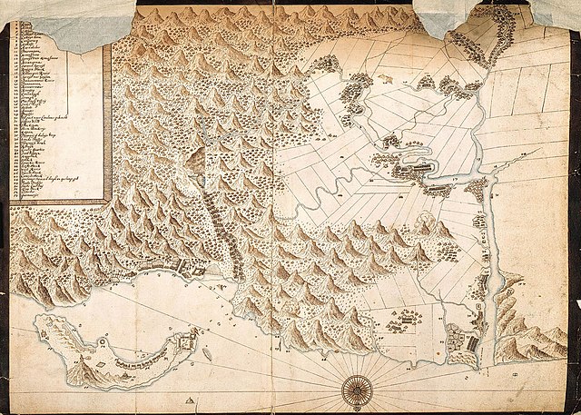
中文(繁體):《大臺北古地圖》
本圖為1654年荷蘭人所繪製的「淡水及其附近村落並雞籠島之圖(Kaartje van Tamsuy en omleggende dorpen, zoo mede het eilandje Kelang)」,簡稱「大臺北古地圖」,彩繪紙本,約為28公分 x 35公分,原藏於荷蘭海牙國家檔案,在日治時期,由臺北帝大的岩生成一教授翻拍重印。由於本圖將當時臺北盆地的原住民聚落,以及大臺北地區的大致地形都弘觀地描繪出來,因此深獲學界的關注。如中村孝志、曹永和、翁佳音等研究者皆曾用此圖作相關考證,而翁佳音還更深入討論圖上的文字、符號,以及相關的歷史,重新檢討與修正早期的北臺歷史。 按:始自大航海時代,荷蘭人即不斷地展開海外的擴張,尤為重視航海圖與地圖的繪製。1640年代初,荷人勢力抵達中部臺灣,並於1642年開始攻下雞籠,並驅逐北臺的西班牙人。其後荷蘭人銳意探查北臺,致力完成各類的報告書與相關地圖繪製,本圖即在荷蘭人海外擴張與深入北臺的背景之下所產生,而描繪出的臺北、淡水雞籠地區更是頗為詳細,曹永和教授即撰文提到:「臺北盆地出現於古地圖較詳細者當以此圖為首次。」 |
||||||||||||||||
| Date | |||||||||||||||||
| Source | http://thcts.ascc.net/tempmap/ra02_2.jpg | ||||||||||||||||
| Author |
|
||||||||||||||||
| Permission (Reusing this file) |
|
||||||||||||||||
| Other versions |
|
||||||||||||||||


中央研究院台灣史研究所 唐立宗 整理
Arranged by 唐立宗 at Institute of Taiwan History,Acadamia Sinica
參見/see also:
2.Archieven » Verzameling Buitenlandse Kaarten Leupe » Inventaris nr. 1127 - Zoeken: Kaartje...
This is an image from the Nationaal Archief, the Dutch National Archives, donated in the context of a partnership program. This tag does not indicate the copyright status of the attached work. A normal copyright tag is still required. See Commons:Licensing.
|
File history
Click on a date/time to view the file as it appeared at that time.
| Date/Time | Thumbnail | Dimensions | User | Comment | |
|---|---|---|---|---|---|
| current | 07:49, 7 May 2014 | | 3,206 × 2,290 (1.91 MB) | Hst0129 (talk | contribs) | User created page with UploadWizard |
You cannot overwrite this file.
File usage on Commons
The following 6 pages use this file:
File usage on other wikis
The following other wikis use this file:
- Usage on es.wikipedia.org
- Usage on nl.wikipedia.org
- Usage on zh-min-nan.wikipedia.org
- Usage on zh.wikipedia.org