File:11-09-fotofluege-cux-allg-25a.jpg
维基共享资源,媒体文件资料库
跳转到导航
跳转到搜索

本预览的尺寸:600 × 600像素。 其他分辨率:240 × 240像素 | 480 × 480像素 | 768 × 768像素 | 1,024 × 1,024像素 | 2,048 × 2,048像素 | 2,848 × 2,848像素。
原始文件 (2,848 × 2,848像素,文件大小:5.53 MB,MIME类型:image/jpeg)
文件信息
结构化数据
说明
说明
添加一行文字以描述该文件所表现的内容
摘要
[编辑]| 描述11-09-fotofluege-cux-allg-25a.jpg |
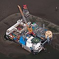
Deutsch: Fotoflug Nordsee; Ölbohrinsel im Ölfeld Mittelplate
English: Germany’s largest oil field Mittelplate
Español: Vista aérea de la plataforma petrolera de Mittelplate, el mayor yacimiento petrolífero de Alemania.
Français : Vue aérienne de Mittelplate, le plus grand champ pétrolifère d'Allemagne
Polski: Platforma wiertnicza na największym niemieckim polu naftowym „Mittelplate” znajdującym się na Morzu Północnym.
Português: Vista aérea da plataforma petrolífera de Mittelplate, o maior campo de petróleo da Alemanha. |
|||||||||||||||||||||||
| 日期 | ||||||||||||||||||||||||
| 来源 | 自己的作品 | |||||||||||||||||||||||
| 作者 |
creator QS:P170,Q15080600
|
|||||||||||||||||||||||
| 授权 (二次使用本文件) |
creator QS:P170,Q15080600 |
|||||||||||||||||||||||
| 其他版本 |
 |
|||||||||||||||||||||||
| 相机位置 | 54° 01′ 19.61″ 北, 8° 44′ 08.41″ 东 | 在以下服务上查看本图像和附近其他图像: OpenStreetMap |
|---|
评价
[编辑]
|

|
English: Germany’s largest oil field Mittelplate 其他语言:
Bosanski: Najveće naftno polje u Njemačkoj, Mittelplate Català: Mittelplate, el camp petrolier més gran d'Alemanya. Deutsch: Fotoflug Nordsee; Ölbohrinsel im Ölfeld Mittelplate English: Germany’s largest oil field Mittelplate Español: Vista aérea de la plataforma petrolera de Mittelplate, el mayor yacimiento petrolífero de Alemania. Italiano: Vista aerea della piattaforma petrolifera di Mittelplate, il principale giacimento petrolifero tedesco. Português: Vista aérea da plataforma petrolífera de Mittelplate, o maior campo de petróleo da Alemanha. Suomi: Mittelplate, suurin öljykentän Saksan. Македонски: Мителплате — најголемото нафтено поле во Германија. Русский: Миттельплате, крупнейшее месторождение нефти Германии. 한국어: 독일에서 가장 큰 유전 미텔플라테. 中文: 德国最大油井 Mittelplate 中文(繁體): 德國最大油井 Mittelplate |

|
This image was selected as picture of the day on Vietnamese Wikipedia.
|
许可协议
[编辑]
|
Dieses Foto entstand aufgrund eines Projektes, das von Wikimedia Deutschland e. V. gefördert wurde.
Im Rahmen des „Community-Projektbudgets“ sollen Luftbilder u.a. von Inseln, Halligen, Sanden und Küstenorten der deutschen Nordseeküste angefertigt werden. Das Projekt „Fotoflüge“ wurde im September 2011 begonnen. |
本文件采用知识共享署名-相同方式共享 3.0 德国许可协议授权。
- 您可以自由地:
- 共享 – 复制、发行并传播本作品
- 修改 – 改编作品
- 惟须遵守下列条件:
- 署名 – 您必须对作品进行署名,提供授权条款的链接,并说明是否对原始内容进行了更改。您可以用任何合理的方式来署名,但不得以任何方式表明许可人认可您或您的使用。
- 相同方式共享 – 如果您再混合、转换或者基于本作品进行创作,您必须以与原先许可协议相同或相兼容的许可协议分发您贡献的作品。

文件历史
点击某个日期/时间查看对应时刻的文件。
| 日期/时间 | 缩略图 | 大小 | 用户 | 备注 | |
|---|---|---|---|---|---|
| 当前 | 2015年1月13日 (二) 20:40 |  | 2,848 × 2,848(5.53 MB) | Ralf Roletschek(留言 | 贡献) | volle Auflösung aus Original |
| 2013年2月28日 (四) 17:13 |  | 2,848 × 2,848(3.94 MB) | Jkadavoor(留言 | 贡献) | Reverted to version as of 21:23, 4 September 2011 per Commons:Overwriting_existing_files#DO_NOT_overwrite : Files that have been awarded a special status like Commons Featured Picture, or similar status on another Wikimedia project. Such files are ... | |
| 2013年2月21日 (四) 15:32 |  | 5,932 × 5,932(14.62 MB) | Ralf Roletschek(留言 | 贡献) | größere Version | |
| 2011年9月4日 (日) 21:23 |  | 2,848 × 2,848(3.94 MB) | Ralf Roletschek(留言 | 贡献) | {{Information |Description=Fotoflug Nordsee |Source={{own}} |Date=2011-09-04 |Author=Ralf Roletschek (<span class="signature-talk">talk</span>) |Permission= |other_versions=[[File:11-09-fotofluege-cux |
您不可以覆盖此文件。
文件用途
以下44个页面使用本文件:
- Drilling rig
- Friedrichskoog
- Oil platform
- Wadden Sea (North Sea)
- User:Ralf Roletschek/gallery/2011-Fotoflug1
- Commons:Featured picture candidates/File:11-09-fotofluege-cux-allg-25a.jpg
- Commons:Featured picture candidates/Log/June 2012
- Commons:Featured picture candidates/Log/March 2013
- Commons:Featured picture candidates/removal/File:11-09-fotofluege-cux-allg-25a.jpg
- Commons:Featured pictures/Places/Industry
- Commons:Featured pictures/chronological/2012-A
- Commons:Picture of the Year/2012/Galleries/2012-A
- Commons:Picture of the Year/2012/Galleries/ALL
- Commons:Picture of the Year/2012/Galleries/Constructions and buildings
- Commons:Picture of the Year/2012/Galleries/Index/10
- Commons:Picture of the Year/2012/Galleries/JUN
- Commons:Picture of the Year/2012/R1/11-09-fotofluege-cux-allg-25a.jpg
- Commons:Picture of the Year/2012/Results/R1/ALL
- Commons:Picture of the Year/2012/Results/R1/ALL/gallery
- Commons:Picture of the Year/2012/Results/R1/ALL/thumbnailtable
- Commons:Picture of the Year/2012/Results/R1/Constructions and buildings
- Commons:Picture of the Year/2013/R1/Test page
- Commons:Quality images/Subject/Places/Man made structures/Buildings, Exterior/Part 2
- Commons:Quality images candidates/Archives September 2011
- Commons:Village pump/Archive/2013/07
- Commons talk:Quality images/Subject/Places/Man made structures
- File:11-09-fotofluege-cux-allg-25.jpg
- Template:Potd/2016-02
- Template:Potd/2016-02-02
- Template:Potd/2016-02-02 (bs)
- Template:Potd/2016-02-02 (cs)
- Template:Potd/2016-02-02 (de)
- Template:Potd/2016-02-02 (en)
- Template:Potd/2016-02-02 (es)
- Template:Potd/2016-02-02 (hu)
- Template:Potd/2016-02-02 (it)
- Template:Potd/2016-02-02 (ko)
- Template:Potd/2016-02-02 (mk)
- Template:Potd/2016-02-02 (nl)
- Template:Potd/2016-02-02 (pt)
- Template:Potd/2016-02-02 (zh-hans)
- Template:Potd/2016-02-02 (zh-hant)
- Category:Mittelplate
- Category:Petroleum engineering
全域文件用途
以下其他wiki使用此文件:
- ar.wikipedia.org上的用途
- ar.wikinews.org上的用途
- be-tarask.wikipedia.org上的用途
- bg.wikipedia.org上的用途
- ca.wikipedia.org上的用途
- ceb.wikipedia.org上的用途
- crh.wikipedia.org上的用途
- cs.wikipedia.org上的用途
- cv.wikipedia.org上的用途
- da.wikipedia.org上的用途
- de.wikipedia.org上的用途
- Wattenmeer (Nordsee)
- Erdöl
- Luftbildfotografie
- Bohrinsel
- Erdölförderung in Deutschland
- Mittelplate (Ölfeld)
- Friedrichskoog
- Nordseeöl
- Recht am Bild der eigenen Sache
- Wikipedia:Projekt Fotoflüge/2011/September
- Wikipedia:Projekt Fotoflüge/Ergebnisse
- Wikipedia Diskussion:Projekt Fotoflugkurs Cuxhaven 2013
- Wikipedia:AdminConvention 2016/Teilnehmer
- Benutzer:Artikelstube/Liste von Bauverfahren
- de.wikiversity.org上的用途
- de.wikivoyage.org上的用途
- el.wikipedia.org上的用途
- en.wikipedia.org上的用途
- North Sea oil
- Wikipedia:WikiProject Energy
- Mittelplate
- Wikipedia:Featured pictures/Places/Architecture
- Marine architecture
- User talk:Ralf Roletschek
- User talk:Nikhil B
- Wikipedia:WikiProject Energy/Recognized content
- Portal:Energy/Explore/Recognized content
- Accommodation platform
- Wikipedia:Featured pictures thumbs/59
- Wikipedia:Featured picture candidates/November-2016
- Wikipedia:Featured picture candidates/Mittelplate
- Wikipedia:Wikipedia Signpost/2016-11-26/Featured content
- Wikipedia:Wikipedia Signpost/Single/2016-11-26
- Wikipedia:WikiProject Germany/Featured Content
查看此文件的更多全域用途。
元数据
此文件含有额外信息,这些信息可能是创建或数字化该文件时使用的数码相机或扫描仪所添加的。如果文件已从其原始状态修改,某些详细信息可能无法完全反映修改后的文件。
| 相机制造商 | NIKON CORPORATION |
|---|---|
| 相机型号 | NIKON D300S |
| 作者 | Ralf Roletschek |
| 著作权持有人 |
|
| 曝光时间 | 1/500秒(0.002) |
| 光圈值 | f/11 |
| 感光度(ISO) | 200 |
| 数据生成日期时间 | 2011年9月4日 (日) 11:12 |
| 镜头焦距 | 82毫米 |
| 用户备注 | Foto by Marcela |
| 高程 | 海平面以上490.348米 |
| 展示的城市 | Friedrichskoog-Spitze |
| 宽度 | 2,848 px |
| 高度 | 2,848 px |
| 每色彩组分位数 |
|
| 像素构成 | RGB |
| 方向 | 正常 |
| 色彩组分数 | 3 |
| 水平分辨率 | 240 dpi |
| 垂直分辨率 | 240 dpi |
| 使用软件 | Adobe Photoshop CC 2014 (Windows) |
| 文件修改日期时间 | 2015年1月13日 (二) 21:38 |
| 曝光程序 | 普通程序 |
| Exif版本 | 2.21 |
| 数字化日期时间 | 2011年9月4日 (日) 11:12 |
| APEX快门速度 | 8.965784 |
| APEX光圈 | 6.918863 |
| APEX曝光补偿 | 0 |
| 最大光圈 | 4.4 APEX(f/4.59) |
| 测光模式 | 多区 |
| 光源 | 未知 |
| 闪光灯 | 闪光灯未点亮 |
| 修改时间厘秒数 | 16 |
| 数据生成时间厘秒数 | 16 |
| 数字化时间厘秒数 | 16 |
| 色彩空间 | sRGB |
| 感光方法 | 单芯片彩色区域传感器 |
| 文件来源 | 数码相机 |
| 场景类型 | 直接拍摄的图像 |
| 自订图像处理 | 普通处理 |
| 曝光模式 | 自动曝光 |
| 白平衡 | 自动白平衡 |
| 数字变焦比率 | 1 |
| 35毫米胶片焦距 | 123毫米 |
| 场景拍摄类型 | 标准 |
| 场景控制 | 无 |
| 对比度 | 标准 |
| 饱和度 | 标准 |
| 锐度 | 标准 |
| 拍摄对象距离范围 | 未知 |
| GPS时间(原子钟) | 09:12 |
| 使用的大地测量数据 | WGS-84 |
| GPS日期 | 2011-09-04 |
| 相机序列号 | 6090043 |
| 使用的镜头 | 50.0-200.0 mm f/4.0-5.6 |
| 评分(满分5分) | 0 |
| 元数据最后修改日期 | 2015年1月13日 (二) 22:38 |
| 原始文件唯一ID | xmp.did:52A5AB643AD7E01196069FB2834CFB77 |
| 关键词 | Friedrichskoog-Spitze, Schleswig-Holstein, Deutschland |
| 展示的国家 | Deutschland |
| 展示的省或州 | Schleswig-Holstein |
结构化数据
此文件中描述的项目
描繪內容
Mittelplate 英语
知识共享署名-相同方式共享3.0德国 简体中文(已转写)
共享资源质量评价 简体中文(已转写)
4 9 2011
54°1'19.607"N, 8°44'8.408"E
image/jpeg
5,793,952 字节
2,848 像素
2,848 像素
曝光时间 简体中文(已转写)
0.002 秒
11
200
82 毫米
隐藏分类:
- Images by Ralf Roletschek/x
- Files with coordinates missing SDC location of creation
- Featured pictures on Wikimedia Commons
- Quality images
- Featured pictures on Wikipedia, English
- Featured pictures on Wikipedia, Persian
- Pictures of the day (2016)
- Featured pictures on Wikipedia, Vietnamese
- CC-BY-SA-3.0-DE
- CPB-Projekt Fotoflüge I
- Fotoflug 2011-09-04
- Featured pictures of industry buildings
- Featured pictures of Schleswig-Holstein
- Quality images by Ralf Roletschek/Deutschland
- Selection WikiCon 2013
- Featured pictures supported by Wikimedia Deutschland
- Featured images by Ralf Roletschek

