File:16th century Spanish trade routes.png
Zur Navigation springen
Zur Suche springen

Größe dieser Vorschau: 800 × 335 Pixel. Weitere Auflösungen: 320 × 134 Pixel | 640 × 268 Pixel | 1.024 × 429 Pixel | 1.280 × 536 Pixel | 2.835 × 1.188 Pixel.
Originaldatei (2.835 × 1.188 Pixel, Dateigröße: 775 KB, MIME-Typ: image/png)
Bildtexte
Kurzbeschreibungen
Ergänze eine einzeilige Erklärung, was diese Datei darstellt.
| Beschreibung |
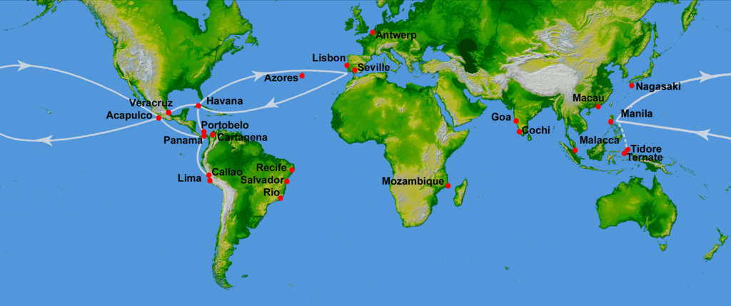
Map showing main Spanish oceanic trade routes in the 16th century, as a result of the exploration during the Age of Discovery.
|
| Datum | (UTC) |
| Quelle | |
| Urheber |
|
| Andere Versionen | File:16th century Portuguese Spanish trade routes.png |
| Dieses Bild wurde digital nachbearbeitet. Folgende Änderungen wurden vorgenommen: depiction of 16th century Portuguese and Spanish trade routes. Das Originalbild kann hier eingesehen werden: World Topography.jpg:
|
This image uses high-resolution digital topography data from NASA's Shuttle Radar Topography Mission (SRTM) at JPL-Caltech [1]. It is in the public domain in the United States.
|
 | |
Ursprüngliches Datei-Logbuch[Bearbeiten]
This image is a derivative work of the following images:
- File:World_Topography.jpg licensed with PD-USGov-NASA-SRTM
- 2009-03-17T12:12:25Z Sk 21600x9049 (17145460 Bytes) {{Information |Description=PIA03395: World in Mercator Projection, Shaded Relief and Colored Height |Source=http://photojournal.jpl.nasa.gov/catalog/PIA03395 |Date=February 2000 |Author=NASA/JPL/NIMA |Permission={{PD-USGov-
Hochgeladen mit derivativeFX
Dateiversionen
Klicke auf einen Zeitpunkt, um diese Version zu laden.
| Version vom | Vorschaubild | Maße | Benutzer | Kommentar | |
|---|---|---|---|---|---|
| aktuell | 18:13, 4. Jul. 2023 | | 2.835 × 1.188 (775 KB) | Koppchen (Diskussion | Beiträge) | {{Information |Description=Wird alles geändert |Source={{own}} |Date= |Author= Koppchen |Permission= |other_versions= }} |
Du kannst diese Datei nicht überschreiben.
Dateiverwendung
Die folgenden 2 Seiten verwenden diese Datei:
Globale Dateiverwendung
Die nachfolgenden anderen Wikis verwenden diese Datei:
- Verwendung auf de.wikipedia.org
Metadaten
Kategorien:
- Maps showing 16th-century history
- Maps of maritime history
- Maps of the Viceroyalty of New Spain
- Manila galleon
- Maps of the Captaincy General of the Philippines
- Age of Discovery
- Asia in the 16th century
- Cuba in the 16th century
- Europe in the 16th century
- Mexico in the 16th century
- South America in the 16th century
- Spain in the 16th century
- Maps of Spanish trade routes
- Maps of the world with Mercator projection