File:1730 Ottens Map of Persia (Iran, Iraq, Turkey) - Geographicus - RegnumPersicum-ottens-1730.jpg
Перейти к навигации
Перейти к поиску
Размер этого предпросмотра: 800 × 455 пкс. Другие разрешения: 320 × 182 пкс | 640 × 364 пкс | 1024 × 583 пкс | 1280 × 728 пкс | 2560 × 1457 пкс | 5000 × 2845 пкс.
Исходный файл (5000 × 2845 пкс, размер файла: 3,6 МБ, MIME-тип: image/jpeg)
Краткие подписи
Краткие подписи
Добавьте однострочное описание того, что собой представляет этот файл
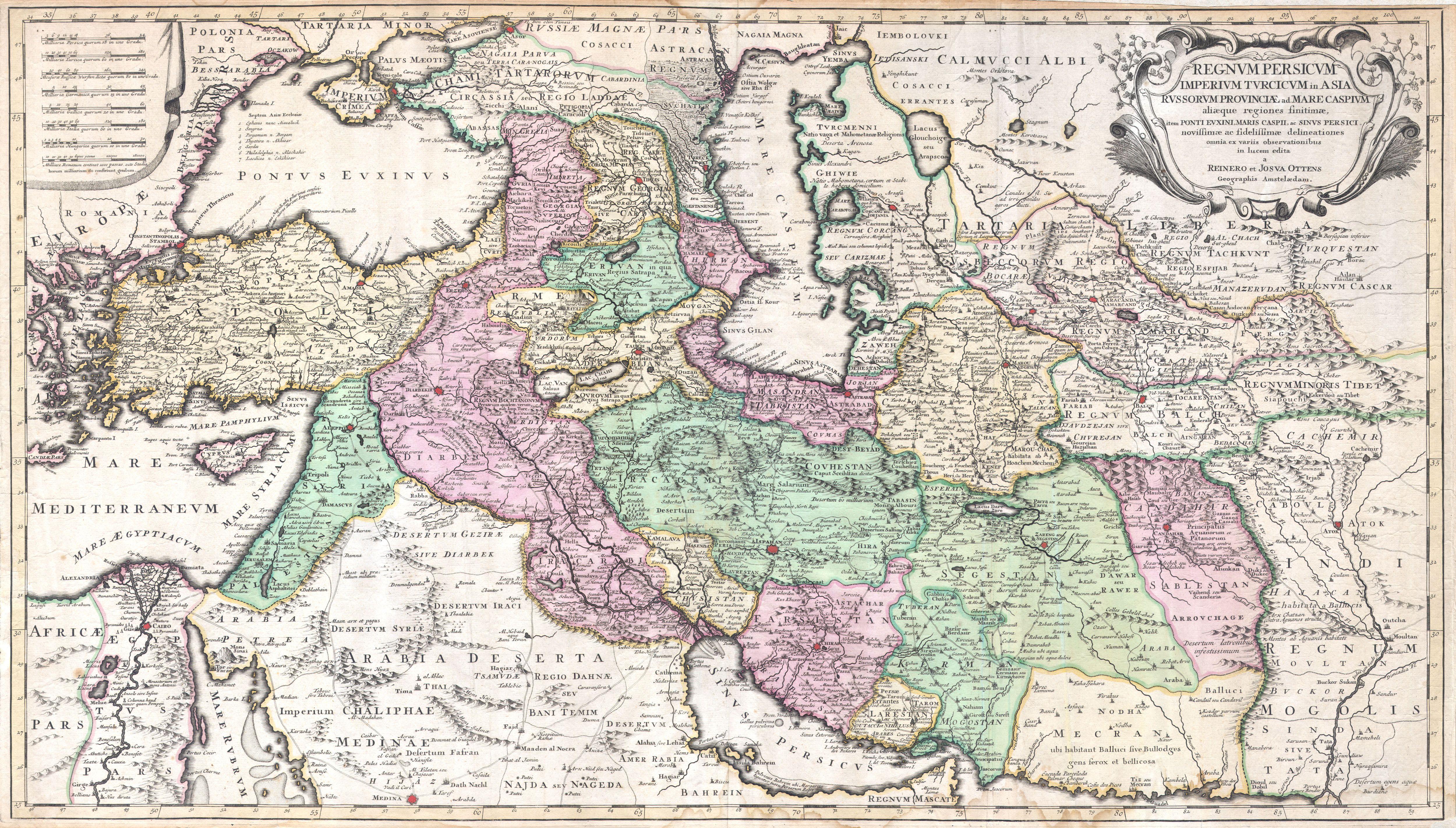
| Regnum Persicum Imperium Turcicum in Asia Russorum Provinciae and Mare Caspium. | ||||||
|---|---|---|---|---|---|---|
| Автор | ||||||
| Название |
Regnum Persicum Imperium Turcicum in Asia Russorum Provinciae and Mare Caspium. |
|||||
| Описание |
English: A scarce and altogether spectacular c. 1730 map of southwestern Asia, specifically focusing on Persia, by Reiner and Joshua Ottens. Covers from Egypt and Greece eastward to include Turkey, the northern part of the Arabian Peninsula, the Black and Caspian Seas, Persia, and Tartary, Afghanistan and Pakistan, including the Indus valley and the western extant of the Mogul Empire. Extends as far north as Asof (Asov) and “Tibet”, and as far south as Medina. Includes superb detail regarding the early 18th century Silk Route trading routes through Persia and Central Asia, noting the important centers of Samarkand, Bukhara and Tashkent. Generally accurate with only a few notable flaws. Most specifically the positioning of Lake Van and Lake Chahi in close proximity to one another. These lakes are in fact separated by over 160 kilometers. Identifies the Pyramids of Egypt, the ruins of Troy, Mt. Sinai, and Mt. Agerdaghi (Mt. Ararat, but labeled Mt. Noah). Upper right quadrant features an attractive title cartouche with baroque ornamentation. Upper left quadrant has eight distance scales on a curtain. |
|||||
| Дата | около 1730(undated) | |||||
| Размеры | высота: 20 дюймов (50,8 см); ширина: 35 дюймов (88,9 см) | |||||
| Инвентарный номер |
Geographicus link: RegnumPersicum-ottens-1730 |
|||||
| Источник/Фотограф |
Independent Issue.
|
|||||
| Права (Повторное использование этого файла) |
|
|||||
| Другие версии | ||||||
_-_Geographicus_-_RegnumPersicum-ottens-1730_(Mecran).jpg)
| Аннотации | Это изображение аннотировано: Просмотреть аннотации на Викискладе |
_-_Geographicus_-_RegnumPersicum-ottens-1730.jpg)
История файла
Нажмите на дату/время, чтобы увидеть версию файла от того времени.
| Дата/время | Миниатюра | Размеры | Участник | Примечание | |
|---|---|---|---|---|---|
| текущий | 16:00, 16 марта 2011 | | 5000 × 2845 (3,6 МБ) | BotMultichill (обсуждение | вклад) | {{subst:User:Multichill/Geographicus |link=http://www.geographicus.com/P/AntiqueMap/RegnumPersicum-ottens-1730 |product_name=1730 Ottens Map of Persia (Iran, Iraq, Turkey) |map_title=Regnum Persicum Imperium Turcicum in Asia Russorum Provinciae and Mare C |
Вы не можете перезаписать этот файл.
Использование файла
Следующие 3 страницы используют этот файл:
_-_Geographicus_-_RegnumPersicum-ottens-1730.jpg)
Глобальное использование файла
Данный файл используется в следующих вики:
- Использование в ar.wikipedia.org
- Использование в azb.wikipedia.org
- Использование в az.wikipedia.org
- Использование в bs.wikipedia.org
- Использование в ca.wikipedia.org
- Использование в da.wikipedia.org
- Использование в de.wikipedia.org
- Использование в el.wikipedia.org
- Использование в en.wikipedia.org
- Использование в es.wikipedia.org
- Использование в et.wikipedia.org
- Использование в fa.wikipedia.org
- Использование в hr.wikipedia.org
- Использование в hy.wikipedia.org
- Использование в it.wikipedia.org
- Использование в ka.wikipedia.org
- Использование в ko.wikipedia.org
- Использование в mk.wikipedia.org
- Использование в ms.wikipedia.org
- Использование в nl.wikipedia.org
- Использование в pnb.wikipedia.org
- Использование в pt.wikipedia.org
- Использование в ru.wikipedia.org
- Использование в sh.wikipedia.org
- Использование в sr.wikipedia.org
Просмотреть глобальное использование этого файла.
_-_Geographicus_-_RegnumPersicum-ottens-1730.jpg)
_-_Geographicus_-_RegnumPersicum-ottens-1730.jpg&oldid=747005497)