File:1747 La Feuille Map of England - Geographicus - England-ratelband-1747.jpg
Jump to navigation
Jump to search

Size of this preview: 800 × 550 pixels. Other resolutions: 320 × 220 pixels | 640 × 440 pixels | 1,024 × 704 pixels | 1,280 × 880 pixels | 2,560 × 1,759 pixels | 3,046 × 2,093 pixels.
Original file (3,046 × 2,093 pixels, file size: 2.31 MB, MIME type: image/jpeg)
Captions
Captions
Add a one-line explanation of what this file represents
| Title |
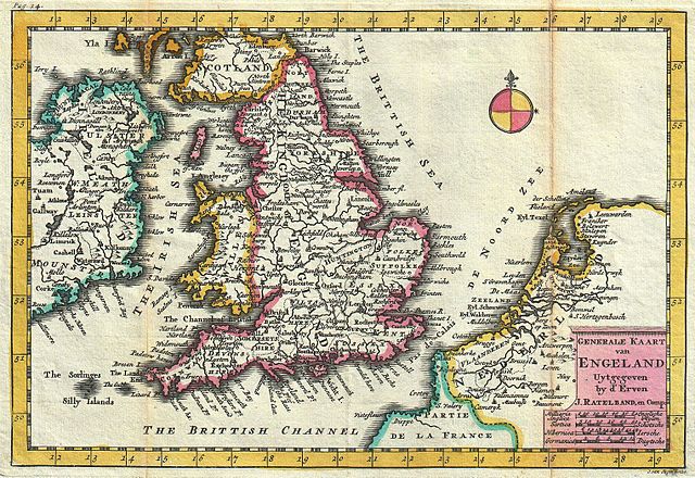
Nederlands: Generale Kaart van Engeland |
|||||||||||||||||||
| Description |
English: A stunning map of England first drawn by Daniel de la Feuille in 1706. Depicts the entirety of England with parts of Ireland, Scotland and the Netherlands. Dutch language title in lower right quadrant. This is Paul de la Feuille’s 1747 reissue of his father Daniel’s 1706 map. The De La Feuille name has been removed from the map and replaced with Ratelband’s. Note in the bottom right quadrant dates this engraving to 1734 and attributes it to J. van Jagen, a prominent Dutch engraver. It was most likely Jagen who re-engraved and updated De La Feuille’s map per Ratelband’s instruction. Prepared for issue as plate no. 16 in J. Ratelband’s 1747 Geographisch-Toneel . |
|||||||||||||||||||
| Date | (dated) | |||||||||||||||||||
| Source |
Geographisch-Toneel Of uitgezochte Kaarten, Tot gemak der Officieren, Reisigers en Liefhebbers; Behelsende alle de generale Kaarten ..., (1747 J. Ratelband issue.)
|
|||||||||||||||||||
| Creator |
|
|||||||||||||||||||
| Permission (Reusing this file) |
|
|||||||||||||||||||
| Georeferencing | If inappropriate please set warp_status = skip to hide. | |||||||||||||||||||
| Archival data | ||||||||||||||||||||
| Accession number |
Geographicus link: England-ratelband-1747 |
|||||||||||||||||||
| Dimensions | height: 7 in (17.7 cm); width: 10.2 in (26 cm) | |||||||||||||||||||
File history
Click on a date/time to view the file as it appeared at that time.
| Date/Time | Thumbnail | Dimensions | User | Comment | |
|---|---|---|---|---|---|
| current | 09:21, 18 March 2011 | | 3,046 × 2,093 (2.31 MB) | BotMultichill (talk | contribs) | {{subst:User:Multichill/Geographicus |link=http://www.geographicus.com/P/AntiqueMap/England-ratelband-1747 |product_name=1747 La Feuille Map of England |map_title=Generale Kaart van Engeland. |description=A stunning map of England first drawn by Daniel d |
You cannot overwrite this file.
File usage on Commons
There are no pages that use this file.
File usage on other wikis
The following other wikis use this file:
- Usage on en.wikipedia.org
- Usage on pl.wikipedia.org