File:1827 Finley Map of South Carolina - Geographicus - SouthCarolina-finley-1827.jpg
Jump to navigation
Jump to search

Size of this preview: 768 × 600 pixels. Other resolutions: 307 × 240 pixels | 615 × 480 pixels | 983 × 768 pixels | 1,280 × 1,000 pixels | 2,560 × 1,999 pixels | 3,000 × 2,343 pixels.
Original file (3,000 × 2,343 pixels, file size: 1.73 MB, MIME type: image/jpeg)
Captions
Captions
Add a one-line explanation of what this file represents
| Anthony Finley: South Carolina
( |
||||||||||||||
|---|---|---|---|---|---|---|---|---|---|---|---|---|---|---|
| Artist |
|
|||||||||||||
| Title |
South Carolina |
|||||||||||||
| Description |
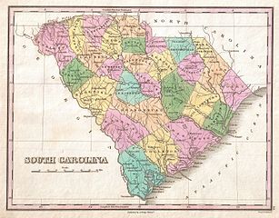
English: A beautiful example of Finley's important 1827 map of South Carolina. This rare map plate configuration depicts the state individually rather than bundled with North Carolina - as is more common. Depicts the state with moderate detail in Finley's classic minimalist style. Shows river ways, roads, canals, and some topographical features. Offers color coding at the county level. Title and scale in lower left quadrant. Engraved by Young and Delleker for the 1827 edition of Anthony Finley's General Atlas . |
|||||||||||||
| Date | 1827 (undated) | |||||||||||||
| Dimensions | height: 9 in (22.8 cm); width: 11.5 in (29.2 cm) | |||||||||||||
| Accession number |
Geographicus link: SouthCarolina-finley-1827 |
|||||||||||||
| Source/Photographer |
Finley, Anthony, A New General Altas, Comprising a Complete Set of Maps, representing the Grand Divisions of the Globe, Together with the several Empires, Kingdoms and States in the World; Compiled from the Best Authorities, and corrected by the Most Recent Discoveries, Philadelphia, 1827.
|
|||||||||||||
| Permission (Reusing this file) |
|
|||||||||||||
| Other versions | ||||||||||||||

File history
Click on a date/time to view the file as it appeared at that time.
| Date/Time | Thumbnail | Dimensions | User | Comment | |
|---|---|---|---|---|---|
| current | 08:37, 23 March 2011 | | 3,000 × 2,343 (1.73 MB) | BotMultichillT (talk | contribs) | {{subst:User:Multichill/Geographicus |link=http://www.geographicus.com/P/AntiqueMap/SouthCarolina-finley-1827 |product_name=1827 Finley Map of South Carolina |map_title=South Carolina |description=A beautiful example of Finley's important 1827 map of Sout |
You cannot overwrite this file.
File usage on Commons
The following 2 pages use this file: