File:1835 Malte-Brun Map of Turkey or the Ottoman Empire in Europe - Geographicus - TurkeyEurope-mb-1837.jpg

Original file (1,602 × 2,220 pixels, file size: 551 KB, MIME type: image/jpeg)
Captions
Captions
| Turquie Europe 1835. | ||||||
|---|---|---|---|---|---|---|
| Artist | ||||||
| Title |
Turquie Europe 1835. |
|||||
| Description |
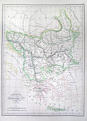
English: This is a beautiful 1835 hand colored map of Turkey or the Ottoman Empire as it extended into Europe during the early 19th century. Includes all of modern day Greece and the Balkans. All text is in French. |
|||||
| Date | 1835 | |||||
| Dimensions | height: 9 in (22.8 cm); width: 12 in (30.4 cm) | |||||
| Accession number |
Geographicus link: TurkeyEurope-mb-1837 |
|||||
| Source/Photographer |
|
|||||
| Permission (Reusing this file) |
|
|||||
File history
Click on a date/time to view the file as it appeared at that time.
| Date/Time | Thumbnail | Dimensions | User | Comment | |
|---|---|---|---|---|---|
| current | 11:21, 16 March 2011 | | 1,602 × 2,220 (551 KB) | BotMultichill (talk | contribs) | {{subst:User:Multichill/Geographicus |link=http://www.geographicus.com/P/AntiqueMap/TurkeyEurope-mb-1837 |product_name=1835 Malte-Brun Map of Turkey or the Ottoman Empire in Europe |map_title=Turquie Europe 1835. |description=This is a beautiful 1835 ha |
You cannot overwrite this file.
File usage on Commons
The following page uses this file:
File usage on other wikis
The following other wikis use this file:
- Usage on ru.wikipedia.org
- Usage on sh.wikipedia.org
- Usage on sr.wikipedia.org