File:1850 Mitchell - Mitchell Map of Turkey in Asia - Geographicus - TurkeyAsia-m-50.jpg
跳至導覽
跳至搜尋

預覽大小:732 × 600 像素。 其他解析度:293 × 240 像素 | 586 × 480 像素 | 937 × 768 像素 | 1,250 × 1,024 像素 | 2,499 × 2,048 像素 | 4,000 × 3,278 像素。
原始檔案 (4,000 × 3,278 像素,檔案大小:3.18 MB,MIME 類型:image/jpeg)
說明
說明
添加單行說明來描述出檔案所代表的內容
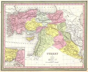
| 塞繆爾·奧古斯都·米切爾:Turkey in Asia.
( |
||||||
|---|---|---|---|---|---|---|
| 作家 | ||||||
| 標題 |
Turkey in Asia. |
|||||
| 描述 |
English: This beautiful hand colored map is a lithographic engraving of Turkey in Asia, dating to 1850. Beautiful map depicts most of modern day nations of Turkey, Iran, Iraq, Israel, Palestine, Jordan, Syria, Lebanon and Kuwait. There is a beautiful inset of the Environs of Constantinople or Istanbul. Produced by the legendary American map publisher S. A. Mitchell Sr. in conjunction with the Cowperthwait firm of Philadelphia, PA. Dated and copyrighted “1850 by Thomas Cowperthwait & Co in the Clerk’s Office of the District court of the Eastern District of Pennsylvania.”. |
|||||
| 日期 | 1850年 | |||||
| 尺寸 | 高度:12.5英寸(31.7釐米);寬度:15英寸(38.1釐米) | |||||
| 登錄號 |
Geographicus link: TurkeyAsia-m-50 |
|||||
| 來源/攝影者 |
|
|||||
| 授權許可 (重用此檔案) |
|
|||||
| 其他版本 | ||||||
.jpg)
檔案歷史
點選日期/時間以檢視該時間的檔案版本。
| 日期/時間 | 縮圖 | 尺寸 | 用戶 | 備註 | |
|---|---|---|---|---|---|
| 目前 | 2011年3月16日 (三) 07:46 | | 4,000 × 3,278(3.18 MB) | BotMultichill(對話 | 貢獻) | {{subst:User:Multichill/Geographicus |link=http://www.geographicus.com/P/AntiqueMap/TurkeyAsia-m-50 |product_name=1850 Mitchell - Mitchell Map of Turkey in Asia |map_title=Turkey in Asia. |description=This beautiful hand colored map is a lithographic en |
無法覆蓋此檔案。
檔案用途
下列2個頁面有用到此檔案:
全域檔案使用狀況
以下其他 wiki 使用了這個檔案:
- ar.wikipedia.org 的使用狀況
- pt.wikipedia.org 的使用狀況
- zh.wikipedia.org 的使用狀況