File:1852 Stansbury Map of Utah and the Great Salt Lake - Geographicus - GreatSaltLake2-stansbury-1852.jpg
Original file (4,233 × 6,000 pixels, file size: 5.7 MB, MIME type: image/jpeg)
Captions
Captions
| Map of the Great Salt Lake and Adjacent Country in the Territory of Utah. | ||||||
|---|---|---|---|---|---|---|
| Artist | ||||||
| Title |
Map of the Great Salt Lake and Adjacent Country in the Territory of Utah. |
|||||
| Description |
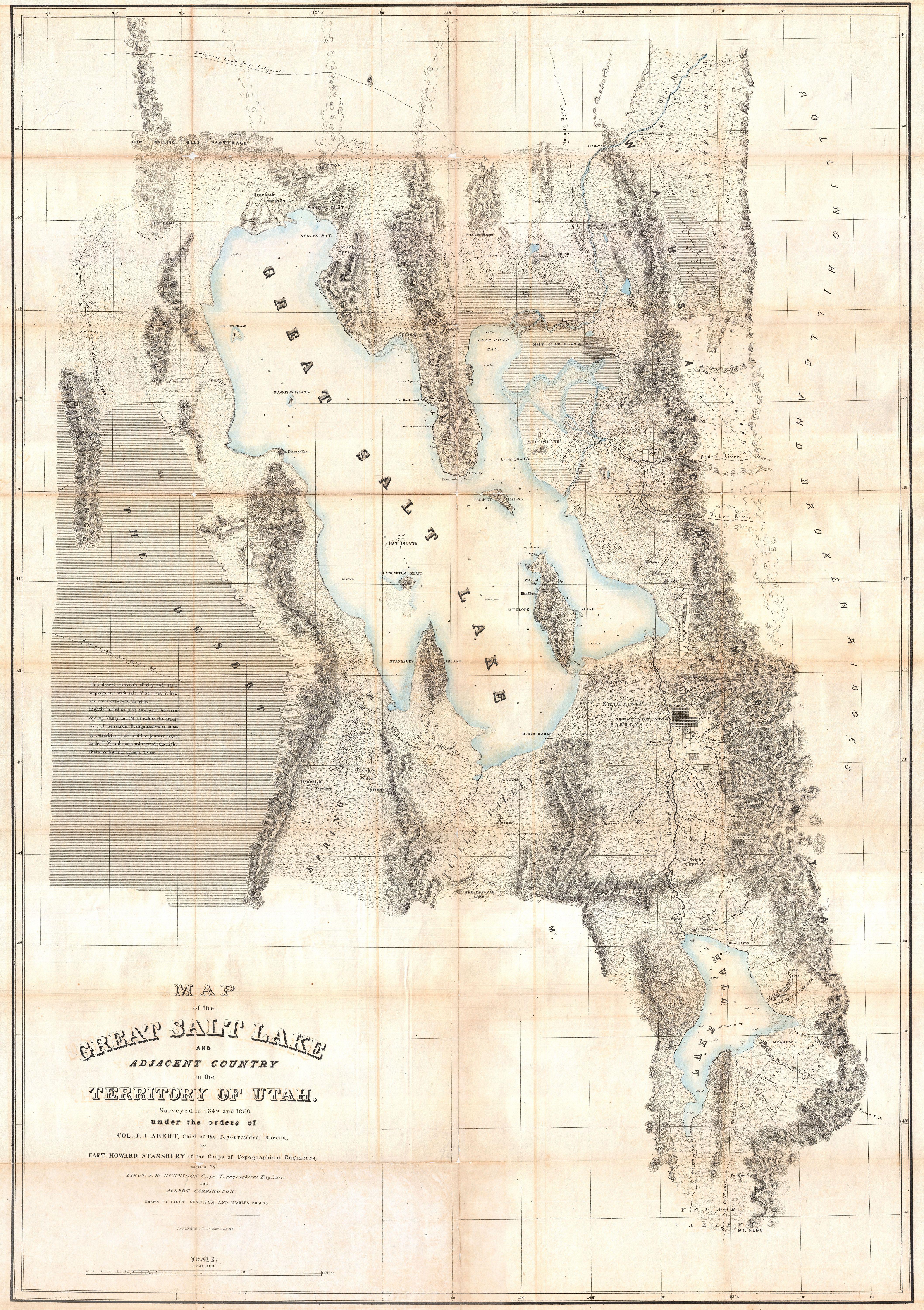
English: It had been a daring feat of exploration, succeeding where the mountain men had all failed, and by means of his map of the western portion of the lake, Stansbury had painted at least one more bold stroke into the unfinished portrait of the national landscape. - William Goetzmann This is Stansbury's seminal 1852 map of the Great Salt Lake region in Utah. It is considered to be the first accurate survey of the Great Basin as well as a cornerstone achievement in the mapping of the American West. The first westerner to visit the Great Basin was most likely Silvestre Vélez de Escalante in the 1776, however, Escalante, who visited Utah Lake to the south, never truly laid eyes on Great Salt Lake. That honor would fall to unnamed trappers and mountain men traveling the region in search of furs and other tradable commodities. Unfortunately, few of these men were literate and did not record their discoveries. The first scientific expedition to this area was headed up by Fremont in 1843. Daunted by the season and climate, Fremont never circumnavigated the lake. That task fell to Howard Stansbury who, in 1849, was assigned by Congress to survey the Great Salt Lake, the Utah Valley, and the emigrant roads passing through the region. Stansbury, working with Gunnison, Carrington, and others, took about two years to complete his survey before presenting it to Congress in 1852. This map was part of that presentation. Covering the region of the Great Basin from the Bear River in the north to Mount Nebo in the south, and from the Rocky Mountains in the west to the Great Plains in the east, Sansbury's map is the result of a monumental feat of exploration and scientific tenacity. The detail throughout is extraordinary, identifying springs, rivers, passes, important buildings, American Indian settlements, canals, etc. Stansbury's work and this map are responsible for creating much of the region's nomenclature, but where it is not, both Mormon and American Indian names are provided. This is also one of the earliest maps to delineate the street plan of Salt Lake City. Stansbury attempts to provide useful information for the traveler. Both the Emigrant Road from California (passing north of the lake) and the Road From California (Passing South of the Lake) are shown. He also provides useful notations for the traveler, such as this one in the lower left quadrant This desert consists of clay and sand impregnated with salt. When wet, it has the consistency of mortar. Lightly loaded wagons can pass between Spring Valley and Pilot Peak in the driest part of the season. Forage and water must be carried for cattle, and the journey begun in the P. M. and continued through the night. Distance between springs 70 ms. . As much as possible, Stansbury includes nautical details and depth sounding for both Great Salt Lake and Utah Lake. In the process of creating a marine survey of the Lake, the Stansbury team was also the first to identify and chart many of Great Salt Lake's Islands ,as might be deduced form their names: Stansbury Island, Carrington Island, Gunnison Island, and Fremont Island. Wheat, in his classic study of American exploration, Mapping the Transmississippi West , devotes considerable attention to this important map, Obviously a major production...an illuminating map of Great Salt Lake, Utah Lake, their respective valleys, and a portion of ‘Youab’ (Juab) Valley to the south.... This map permanently established the cartography and many place names of northwestern Utah.... One of its most attractive features is that it gives the Indian as well as the Mormon names of the various creeks draining from the mountains. For Great Salt Lake itself the map was definitive, of course, permanent names being given to all the islands and shoreline features.... |
|||||
| Date | 1852 (undated) | |||||
| Dimensions | height: 44 in (111.7 cm); width: 31 in (78.7 cm) | |||||
| Accession number |
Geographicus link: GreatSaltLake2-stansbury-1852 |
|||||
| Source/Photographer |
Stansbury, H. J., An Expedition to the Valley of the Great Salt Lake of Utah…, 1852.
|
|||||
| Permission (Reusing this file) |
|
|||||
| Other versions |
 |
|||||
]
File history
Click on a date/time to view the file as it appeared at that time.
| Date/Time | Thumbnail | Dimensions | User | Comment | |
|---|---|---|---|---|---|
| current | 18:37, 24 March 2011 | | 4,233 × 6,000 (5.7 MB) | BotMultichillT (talk | contribs) | {{subst:User:Multichill/Geographicus |link=http://www.geographicus.com/P/AntiqueMap/GreatSaltLake2-stansbury-1852 |product_name=1852 Stansbury Map of Utah and the Great Salt Lake |map_title=Map of the Great Salt Lake and Adjacent Country in the Territory |
You cannot overwrite this file.
File usage on Commons
The following 2 pages use this file:
File usage on other wikis
The following other wikis use this file:
- Usage on cs.wikipedia.org
- Usage on de.wikipedia.org
- Usage on en.wikipedia.org
- Antelope Island
- Bear River (Great Salt Lake)
- Bear River Bay
- Benson Grist Mill
- Black Rock (Tooele County, Utah)
- Blacksmith Fork
- Box Elder Creek (Utah)
- Carrington Island (Utah)
- Cedar Valley (Utah County, Utah)
- City Creek (Salt Lake County, Utah)
- Emmigration Creek (Utah)
- Ensign Peak
- Fort Utah
- Fremont Island
- Goshen Valley
- Gunnison Island
- Hat Island (Utah)
- High Creek (Utah)
- Hobble Creek (Utah County, Utah)
- Hogup Mountains
- Juab Valley
- Lakeside Mountains
- Logan River (Utah-Idaho)
- Lone Peak (Utah)
- Lone Rock (Great Salt Lake Desert)
- Malad River (Idaho-Utah)
- Maps of the Great Basin (United States)
- Mill Creek (Salt Lake County, Utah)
- Mount Nebo (Utah)
- Monument Peak (Box Elder County, Utah
- Newfoundland Mountains
- Ogden River
- Maps of Ogden, Utah
- Oquirrh Mountains
- Parleys Creek
- Peteetneet Creek
- Promontory Mountains
- Red Butte Creek (Salt Lake County, Utah)
- Red Dome (Utah)
- Rush Lake (Tooele County, Utah)
- Rush Valley
- Salt Lake Valley
- Skull Valley (Utah)
- Sixmile Creek (Tooele County, Utah)
- Spanish Fork (river)
- Spring Bay (Utah)
- Stansbury Island
- Stansbury Mountains
- Tooele Valley
- Buildings in Tooele, Utah
- Traverse Mountains
- Twin Peaks (Salt Lake County, Utah)
- Utah Valley
- Wasatch Range
- Weber River
- White Rock Bay (Utah)
- Willow Creek (Jordan River tributary)
- Islands of the Great Salt Lake
- 1852 maps of Utah
- Maps related to Mormonism
- Maps of the Great Salt Lake