File:1857 Colton Map of New York City, New York - Geographicus - NewYorkCity-colton-1857.jpg
Jump to navigation
Jump to search
No higher resolution available.
1857_Colton_Map_of_New_York_City,_New_York_-_Geographicus_-_NewYorkCity-colton-1857.jpg (600 × 376 pixels, file size: 96 KB, MIME type: image/jpeg)
Captions
Captions
Add a one-line explanation of what this file represents
| J. H. Colton: Map of New York and the Adjacent Cities.
( |
|||||||||||||||||||||
|---|---|---|---|---|---|---|---|---|---|---|---|---|---|---|---|---|---|---|---|---|---|
| Artist |
|
||||||||||||||||||||
| Title |
Map of New York and the Adjacent Cities. |
||||||||||||||||||||
| Description |
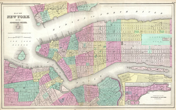
English: A rare and beautiful example of J. H. Colton map of New York City and vicinity, including Manhattan as well as parts of Brooklyn, Jersey City, Hoboken, and Queens. This is the third state of this map and one of the least common. In this variant Olmstead’s Central Park appears for the first time, but as the planning commission has yet to lay out the park, its interior is blank. This important map would become the template from which Johnson and late later S. A. Mitchell Jr. would build their own New York City maps. Beautiful hand color. Wonderful attention to detail includes individual streets and even important buildings and parks. Originally prepared as plates no 19 and 20 in J. H. Colton’s 1857 single volume issue of the Atlas of the World… . This is one of the few editions of Colton's Atlas to appear without the distinctive spiral-form Colton border design. Dated and copyrighted: “Entered according to the Act of Congress in the Year of 1855 by J. H. Colton & Co. in the Clerk’s Office of the District Court of the United States for the Southern District of New York.” Published from Colton’s 172 William Str. Office in New York. |
||||||||||||||||||||
| Date | 1857 (dated 1855) | ||||||||||||||||||||
| Dimensions | height: 16 in (40.6 cm); width: 25.5 in (64.7 cm) | ||||||||||||||||||||
| Accession number |
Geographicus link: NewYorkCity-colton-1857 |
||||||||||||||||||||
| Source/Photographer |
Colton, G.W. & C.B., Colton's General Atlas., (1857 editon).
|
||||||||||||||||||||
| Permission (Reusing this file) |
|
||||||||||||||||||||

File history
Click on a date/time to view the file as it appeared at that time.
| Date/Time | Thumbnail | Dimensions | User | Comment | |
|---|---|---|---|---|---|
| current | 13:33, 25 March 2011 | | 600 × 376 (96 KB) | Multichill (talk | contribs) | Low res is better than nothing at all. |
| 13:29, 25 March 2011 |  | 5,000 × 5,357 (410 KB) | BotMultichillT (talk | contribs) | {{subst:User:Multichill/Geographicus |link=http://www.geographicus.com/P/AntiqueMap/NewYorkCity-colton-1857 |product_name=1857 Colton Map of New York City, New York |map_title=Map of New York and the Adjacent Cities. |description=A rare and beautiful exam |
You cannot overwrite this file.
File usage on Commons
The following page uses this file:
File usage on other wikis
The following other wikis use this file:
- Usage on fr.wikipedia.org