File:1873 Beers Map of South Hempstead, Long Island, New York - Geographicus - HempsteadSouth-beers-1873.jpg
Перейти к навигации
Перейти к поиску
Размер этого предпросмотра: 800 × 371 пкс. Другие разрешения: 320 × 148 пкс | 640 × 297 пкс | 1024 × 475 пкс | 1280 × 593 пкс | 2560 × 1186 пкс | 5000 × 2317 пкс.
Исходный файл (5000 × 2317 пкс, размер файла: 3,17 МБ, MIME-тип: image/jpeg)
Краткие подписи
Краткие подписи
Добавьте однострочное описание того, что собой представляет этот файл
| South part of Hempstead, Queens Co. L.I. | ||||
|---|---|---|---|---|
| Автор | ||||
| Название |
South part of Hempstead, Queens Co. L.I. |
|||
| Описание |
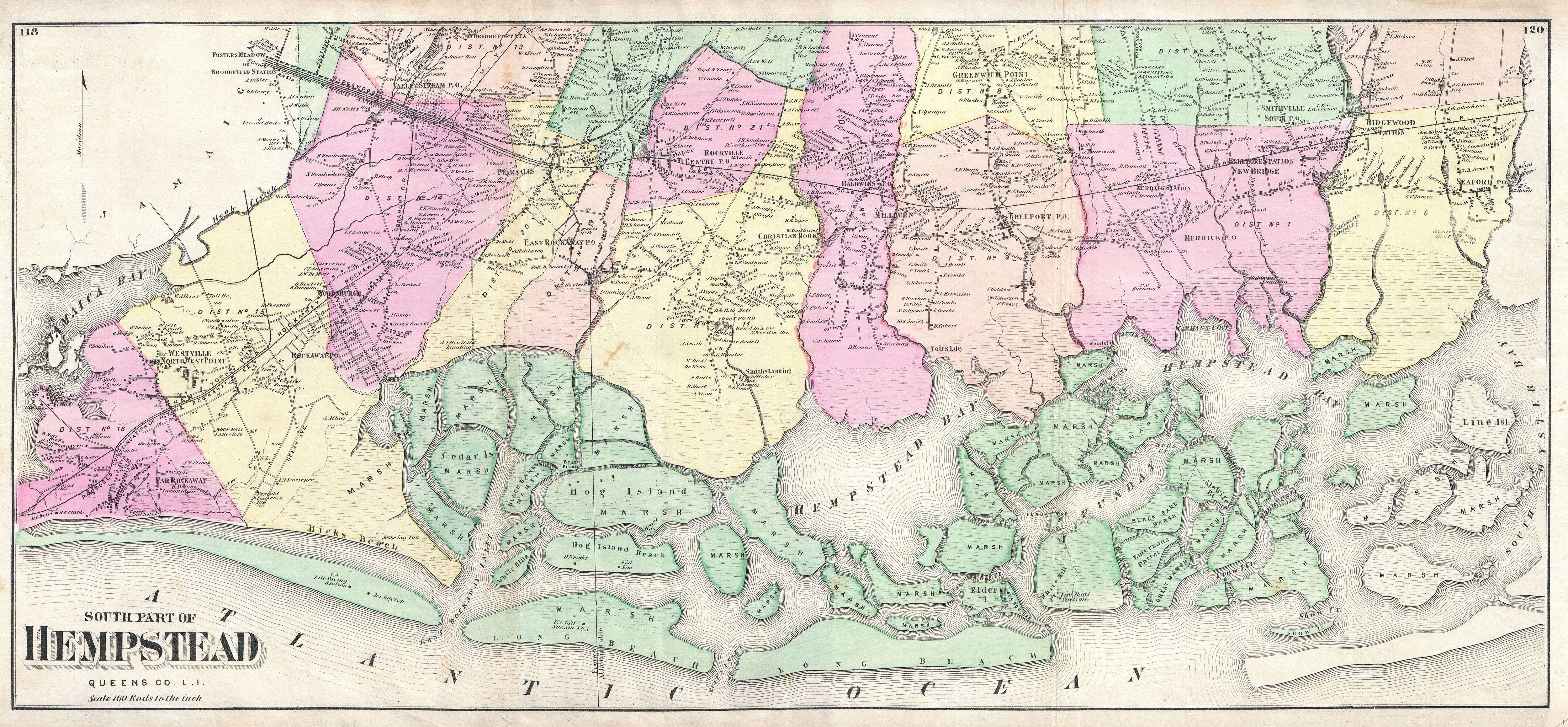
English: A scarce example of Fredrick W. Beers’ map of the southern part of Hempstead, Long Island, New York. Published in 1873, this magnificent map covers from Jamaica Bay and Far Rockaway eastward past Hicks Beach, Hog Island, Long Beach, Rockville, Freeport, Hempstead Bay to South Oyster Bay and Seaford. Wonderful detail regarding the marsh island around Long Beach and Hempstead Bay. Offers stupendous inland detail to the level of individual buildings and the names of land holders. Notes the route of the South Side Rail Road. This is probably the finest atlas map of Hempstead to appear in the 19th century. Prepared by Beers, Comstock & Cline out of their office at 36 Vesey Street, New York City, for inclusion in the first published atlas of Long Island, the 1873 issue of Atlas of Long Island, New York. |
|||
| Дата | 1873 (undated) | |||
| Размеры | высота: 14,5 дюймов (36,8 см); ширина: 31,5 дюймов (80 см) | |||
| Инвентарный номер |
Geographicus link: HempsteadSouth-beers-1873 |
|||
| Источник/Фотограф |
Atlas of Long Island, New York. From Recent Actual Surveys and Records Under the Superintendence of F. W. Beers. (1873 First Edition).
|
|||
| Права (Повторное использование этого файла) |
|
|||
| Другие версии | File:South part of Hempstead, Queens Co. L.I. NYPL1527312.tiff | |||

История файла
Нажмите на дату/время, чтобы увидеть версию файла от того времени.
| Дата/время | Миниатюра | Размеры | Участник | Примечание | |
|---|---|---|---|---|---|
| текущий | 16:53, 16 марта 2011 | | 5000 × 2317 (3,17 МБ) | BotMultichill (обсуждение | вклад) | {{subst:User:Multichill/Geographicus |link=http://www.geographicus.com/P/AntiqueMap/HempsteadSouth-beers-1873 |product_name=1873 Beers Map of South Hempstead, Long Island, New York |map_title=South part of Hempstead, Queens Co. L.I. |description=A scarce |
Вы не можете перезаписать этот файл.
Использование файла
Следующие 2 страницы используют этот файл: