File:1873 Beers Map of Woodhaven, Queens, New York City - Geographicus - Woodhaven-beers-1873.jpg

Original file (4,000 × 5,180 pixels, file size: 4.8 MB, MIME type: image/jpeg)
Captions
Captions
| Woodhaven, Town of Jamaica, Queens Co. - Freeport, Townof Hempstead, Queens Co. - Inglewood or Queens, Town of Hempstead, Queens Co. | ||||||
|---|---|---|---|---|---|---|
| Artist | ||||||
| Title |
Woodhaven, Town of Jamaica, Queens Co. - Freeport, Townof Hempstead, Queens Co. - Inglewood or Queens, Town of Hempstead, Queens Co. |
|||||
| Description |
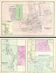
English: A scarce example of Fredrick W. Beers’ map of the town of Woodhaven, Queens, New York City. Published in 1873. Covers from Unionville past the Union Race Course along Atlantic Avenue to Grand Street. Extends as far south as Liberty Avenue and as far north as the Jamaica Plank Road. Lower left quadrant features an inset plan of South Woodhaven. Verso features city plans of Freeport, Greenwich Point, Springfield Store, Willow Tree Station and Inglewood. Detailed to the level of individual buildings and properties with land owners noted. This is probably the finest atlas map of the town of Woodhaven, Queens, to appear in the 19th century. Prepared by Beers, Comstock & Cline out of their office at 36 Vesey Street, New York City, for inclusion in the first published atlas of Long Island, the 1873 issue of Atlas of Long Island, New York. |
|||||
| Date | 1873 (undated) | |||||
| Dimensions | height: 15 in (38.1 cm); width: 21.5 in (54.6 cm) | |||||
| Accession number |
Geographicus link: Woodhaven-beers-1873 |
|||||
| Source/Photographer |
Atlas of Long Island, New York. From Recent Actual Surveys and Records Under the Superintendence of F. W. Beers. (1873 First Edition).
|
|||||
| Permission (Reusing this file) |
|
|||||
| Other versions |
File:Woodhaven, Town of Jamaica, Queens Co. - South Woodhaven, Town of Jamaica, Queens Co. NYPL1527301.tiff File:1873-Union Course.jpg File:Springfield Store. Tn. of Jamaica, Queens Co. - Willow Tree Station. Town of Jamaica, Queens Co. - Inglewood or Queens. Town of Hempstead, Queens Co. NYPL1527300.tiff File:Freeport, Town of Hempstead, Queens Co. - Greenwich Point, Town of Hempstead, Queens Co. NYPL1527302.tiff |
|||||
File history
Click on a date/time to view the file as it appeared at that time.
| Date/Time | Thumbnail | Dimensions | User | Comment | |
|---|---|---|---|---|---|
| current | 18:42, 16 March 2011 | | 4,000 × 5,180 (4.8 MB) | BotMultichill (talk | contribs) | {{subst:User:Multichill/Geographicus |link=http://www.geographicus.com/P/AntiqueMap/Woodhaven-beers-1873 |product_name=1873 Beers Map of Woodhaven, Queens, New York City |map_title=Woodhaven, Town of Jamaica, Queens Co. - Freeport, Townof Hempstead, Queen |
You cannot overwrite this file.
File usage on Commons
The following page uses this file:
File usage on other wikis
The following other wikis use this file:
- Usage on en.wikipedia.org